
Gehrenberg
| Gehrenberg | ||
|---|---|---|
 |
||
| height | 751.9 m above sea level NHN | |
| location | Baden-Wuerttemberg , Germany | |
| Dominance | 7.4 km → highest | |
| Notch height | 245 m | |
| Coordinates | 47 ° 44 '30 " N , 9 ° 25' 26" E | |
|
||
| rock | Molasses | |
| particularities | Gehrenberg Tower ( AT ) | |

The Gehrenberg is one of the highest mountains in Linzgau and the local mountain of the town of Markdorf , its highest point is on the Stadtbühl at 751.9 m above sea level. NHN .
geography
The Gehrenberg is located in the south of Baden-Württemberg , about ten kilometers north of Lake Constance . At the foot of the southern slope - where the Brunnisach rises - lies the town of Markdorf , other parts of the mountain belong to the communities of Bermatingen , Salem , Deggenhausertal and Oberteuringen . To get from there to the next higher mountain, you have to descend at least 245 meters from the summit ( Schartenhöhe ). The dominance , the distance from the summit to the next higher point in the area near Wahlweiler on the slope of the highest , is 7.4 kilometers.
Gehrenberg tower
The Gehrenberg tower is a 30 m high, steel frame construction designed observation tower at 704 m above sea level. NHN at 47 ° 44 '10 " N , 9 ° 24' 14" O . It is said to have a certain resemblance to the Eiffel Tower , as the struts between the tower feet are rounded at the top (but not as a round arch, as in the Eiffel Tower). From the viewing platform of the Gehrenberg tower, which was built in 1903, you have an all-round view of Markdorf, Lake Constance and the Alps , as well as the highest in good weather . The tower is only accessible until sunset and is then automatically closed. The Gehrenberg tower belongs to the town of Markdorf, although it is in the district of the municipality of Deggenhausertal. It carries antennas for various radio services and houses an amateur radio relay.
Hiking trails
Several regional and national hiking trails run over the Gehrenberg, including the Swabian-Alb-Oberschwaben-Weg (HW 7) and the Jubiläumsweg Bodenseekreis , a 111-kilometer hiking trail that was signposted in 1998 for the 25th anniversary of the Bodenseekreis. This leads over six stages through the hinterland of Lake Constance from Kressbronn via Neukirch , Meckenbeuren , Markdorf, Heiligenberg and Owingen to Überlingen . One of the hiking trails leads past the so-called summit hut . A detour to the summit is possible from here. This is completely in the forest and therefore does not allow any view.
The Bodensee LandGänge are three circular hiking trails that have been awarded the German hiking seal . The tours are "impossible to run" thanks to the high-quality and hiker-friendly signage and can be done in both directions. The yellow signposts and the Bodensee-LandGänge markers lead safely along the way. The three certified Bodensee LandGänge "Gehrenberg GuckinsLand", "Bermatinger Waldwiesen" and "Bergtour Höchst" are designed as self-contained circular hiking trails with a common starting point and destination. The spectrum ranges from the easy half-day tour to the sometimes difficult full-day tour. The varied routes lead mostly on forest and field paths as well as natural paths.
history
- 1903: The observation tower is inaugurated under the name Großherzog-Friedrich-Warte .
- around 1911: approx. 300 m west of the observation tower, a landslide occurs over a width of 100 m; this demolition point is still recognizable today as a “ slide ”. It is said to be related to a strong earthquake on November 16, 1911.
- 2004: Below the highest point of the mountain at 47 ° 44'35 "N 9 ° 25'24" E an approximately 70 m high radio tower is built.
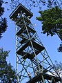
Gehrenberg tower

Gehrenberg tower, entrance

The so-called Gehrenberg slide

View from the foot of the Gehrenberg to Markdorf and Lake Constance

On the top


literature
- Markdorf. History and present. Kehrer Verlag, Freiburg im Breisgau 1989.
Web links
- Map of the Gehrenberg with hiking trails on: Geoportal Baden-Württemberg ( information )
- Information about the observation tower
- Controllable webcam from the Gehrenberg observation tower
- Height information board at the highest point on Gehrenberg