Lauter (Danube)
| Big louder | ||
|
meandering in the wide valley, slope with NSG-protected juniper heather in front of Buttenhausen |
||
| Data | ||
| Water code | EN : 1134 | |
| location |
Swabian Alb
|
|
| River system | Danube | |
| Drain over | Danube → Black Sea | |
| source | at Offenhausen 48 ° 23 '57 " N , 9 ° 22' 4" E |
|
| Source height | 665.1 m above sea level NHN | |
| Spring discharge |
MQ |
200 l / s |
| muzzle | a good kilometer south of Lauterach in the Danube Coordinates: 48 ° 14 ′ 40 " N , 9 ° 34 ′ 54" E 48 ° 14 ′ 40 " N , 9 ° 34 ′ 54" E |
|
| Mouth height | 507.5 m above sea level NHN | |
| Height difference | 157.6 m | |
| Bottom slope | 3.7 ‰ | |
| length | 42.3 km | |
| Catchment area | 326.721 km² | |
| Outflow at the Lauterach gauge |
MNQ MQ |
410 l / s 1.65 m³ / s |
| Communities | Gomadingen , Hayingen , Ehingen , Lauterach | |
The Lauter (also Great Lauter ) is a 42 km long left tributary of the Danube in the area of the Swabian Alb in southern Baden-Württemberg .
The romantic river valley of the Great Lauter is a very popular destination on its entire route because of numerous river history, historical and scenic attractions.
geography
The source of the Lauter is at the stud farm in the village of Offenhausen von Gomadingen in the Reutlingen district ; the basin of the now small river continues as a predominantly dry Kohlstetter valley approx. 8 km up and westwards to almost the Albtrauf above the village of Honau von Lichtenstein .
The Große Lauter flows about 44 km in its basin on the plateau of the Swabian Alb over a large area to the southeast. Shortly after Obermarchtal in the Alb-Donau district , the river flows into the Upper Danube from the left . The Große Lauter is now a small river with a predominantly narrow, often gorge-like, wide valley, but also with several wide, gentle valley sections where the river meanders slowly . Numerous castle ruins in narrow passages line the valley. With two exceptions, a driveway runs through the valley and connects its settlement areas.
On the upper reaches of the river there are three places in close proximity or directly on the river, which also belong to the regional economic center of Münsingen by their size : Groß- and Klein- Engstingen with around 5000 inhabitants, Gomadingen with around 2300 inhabitants and Buttenhausen with around 600 inhabitants . The numerous other settlements in the valley are usually smaller or at most as large as Buttenhausen.
geology
Great past of a primordial river
In southwest Germany there are many rivers that are called "Lauter". Of these, the Große Lauter and five smaller ones flow directly onto the Swabian Alb, or they draw their spring water in whole or in part from the Alb and arise near the Alb eaves. The Great Lauter and its forerunner, the Urlauter, are among those four other rivers that flow into the Danube on the Swabian Alb that still cross the entire Swabian Alb almost entirely above ground. These rivers were already channels in the Miocene, which dates back more than 10 million years . At that time, the Große Lauter also drained the plateau of the Swabian Alb, which reached many kilometers further north.
The broad Lautertal with its small river, barely 4 m wide, was sunk into the mass limestone of the Upper Jura by a huge river carrying water . The numerous tributaries of the Lauter also fed the river. Today the side valleys have almost all completely dried out due to a “mature” karstification of the entire Alb. The lower reaches of the Gächinger Lauter and the Dolderbach near Marbach periodically supply the river with a little more water.
The great age of the Great Lauter, which first drains to the Graupensandrinne , then to the Urdonau and then to the Upper Danube, is documented by geological publications in pictures and text. In several long periods of time, the Great Lauter - always following the deepening and changing course of the Danube - had to sink into the hard mass limestone. Since the late Pleistocene, the deepening was followed at times by meter-thick, finer sedimentations and flood sediments . In the last interglacial of the Würm Ice Age (late Pleistocene) and in the warm period of the Atlantic there were also heavy limestone tufa deposits . The result was a fertile, partly wide, flat valley meadow landscape.
Visible relics of geological earlier times

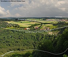
Old branches of the spring, which surely also reached into the foothills of the Alb and several side valleys flowing towards the Urlauter, determined the size of the upper reaches of the Große Lauter up to today's karst spring in Offenhausen . Since the Alb eaves was further north, the drainage area was also much larger. Climatic fluctuations, but generally falling average temperatures, the "aggressive" advancing "Rhenish" side valleys into the Alb plateau - including the Echaz - pushed back the night eaves and narrowed the catchment area of the Urlauter. The two photos illustrate an important intermediate phase. The wide, flat Plio-Pleistocene dry valley of the Große Lauter is easily recognizable on the Echaztobel (local Albtrauf) and 7 km further, around 1 km from today's karst spring.
The river dynamics formed meanders on the early surface of the Alb plateau. Great erosion forces and fluctuating amounts of water gradually deepened the river in the hard mass limestone and forced the meander loop - even if it varied its loop shape several times - to also deepen. Gradually sling and emerged Umlaufberg of Gundelfingen . A mighty, around 100 m high impact slope was created (see below).
Stations of the river to the mouth
The Rhenish Echaz has driven an eaves bay more than 100 m deep into the Albkörper and moved the Alb eaves far back to Lichtenstein train station. From here, the valley floor of the old Große Lauter continues as a slightly terraced dry valley to the current karst spring in Offenhausen.
source
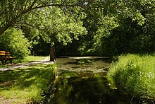
The karst spring, dammed up into a source pot and protected as a geotope , rises from the right wall of the dry valley of the Große Lauter coming from Kohlstetten from the lower mass limestone (level of the lower rock limestone formation / Kimmeridgium / ki2), in Offenhausen . The spring lake is idyllically located within a large area, which is surrounded on three sides by the still intact wall of a former women's convent. The monastery church (now a stud museum), which was previously a hay barn, the horse stables and agricultural buildings belong to the main and state stud Marbach .
Meandering valley
From Marbach to the entry into the hard mass limestone before Hundersingen and again after the Gundelfinger Umlaufberg to the small slope at the “Hohen Gießel” / karst spring “Blaubrunnen”, the Lauter has formed beautiful meanders. Meanders always form when the river water dynamics act long enough with a relatively low bed gradient, a relatively wide valley with wash-off masses of seasonal or otherwise climatically-related greater abundance of water and no massive obstacles . But even in the rocky sections, meanders near the surface originally deepened into the terrain , depending on the layer conditions of the relief . Today the topography of the Lauter is characterized by meandering mountains in these sections .
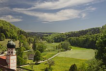
One of the typical views of a karstified Alb river is offered in Bichishausen. On the horizon, the Lauter turns right into the large loop that leads it around the not quite cut off Umlaufberg near the village of Gundelfingen. Under the surface of the fertile valley floor there are embankment sediments, among others. a. Lime pebbles, debris, coarse gravel, more or less organic matter, stony loam, peat. One phenomenon is the continuous tuff limestone bar of varying thicknesses that formed in the warm period of the last Ice Age. The geologically striking limestone tufa sediment continued to settle for a further 2 km beyond the horizon - over the entire Gundelfinger loop to the mouth of the Heiligental valley, south of the Wittsteig patch. The great width of the valley for today's small Große Lauter goes back to geological epochs in which the river was not only considerably larger during floods. In the foreground of the photo is the tower of the Catholic parish church built in 1735 in the Baroque style.
Umlaufberg
A meander loop from an early Great Lauter, which flows on a barely deepened Albo surface, gradually dug itself into the hard mass limestone of the Gundelfinger Lauter loop. This gradually modeled the Umlaufberg and the mighty impact slope. The right flank of the rebound slope, called a rump called juniper heather , was used for grazing by flocks of sheep. The Lauterbett, which has now shrunk to a small size, and the Gleithang , which has been piled up on both sides of the Umlaufberg , offered plenty of space for arable and pasture areas and for the small village of Gundelfingen . The north-south autostraße of the Lautertal overcomes the spur of the Umlaufberg, which is only a few meters above the river valley, by the shortest route.
Canyon-like valley
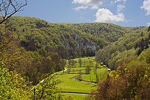
The two valley sections of Anhausen-Unterwilzingen-Laufenmühle (5.4 and 2.3 km), where the Lauter has to be eroded by mass limestone cliffs (with a 1.3 km interruption of a flat-wide valley section), can and may only be on foot or by Bike to be mastered. The Lauter has produced steep slopes here. Craggy rocks visible from the valley path make it clear that the river deepening in the rocky, hard terrain was difficult; they force the river to meander again and again. Most of the time, a vegetation with deciduous trees and bushes that reaches down to the valley floor and uses every humus-rich rocky outcrop hide the view of the rugged rock faces. A flat sedimented valley floor with the poor Lauter rivulet leaves just space for a meadow carpet and a gravel path.
Apart from the fact that the construction of a road here would have been a very expensive undertaking if the landscape is not to be destroyed by it, reason, perhaps also awe of the grandiosity of nature, has triumphed here. Where there is a car road elsewhere in the valley, warning signs warn motorcyclists in particular not to disturb the valley residents with engine noise. Especially on weekends, the text seems to be justified: "Drive slowly and quietly, otherwise there is a driving ban!"
Halfway in the first part of the gorge are the four-meter-high Geotope Hoher Gießel, which is stepped by a limestone terrace, and the karst spring Blaubrunnen, geologically connected to this slope, at the lower edge of the limestone terrace . Further geological publications on these phenomena are very rare.
The “Lautertal Fault” crosses three kilometers after Anhausen, a fault that is around 15 km long and divided into three levels of movement and age. The youngest, obermiozäne part of the fault, south of the Lauter at Oberwilzingen has a here deportation stage left from 100 to 115 meters. The fault of the southern floe can also be clearly seen with the naked eye. The fault did not affect the river or valley.
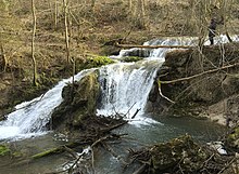
At the end of the second road-free section (up to Laufenmühle) the second, 1.7 km long tufa bar of the Untere Große Lauter ends. In the photo (waterfall at the Laufenmühle), a seven meter high, stepped karst waterfall, the thick tufa sediment can still be clearly seen. Here at the Laufenmühle, a 60 m thick layer of tufa limestone was mined in a quarry until around 1950.
Special features in places on the river
Offenhausen

Hydroelectric power plant
Immediately behind the dammed spring lake of the Lauter spring and the monastery wall, the water of the spring falls 3 m deeper with a discharge of approx. 200 to 1500 l / s. For half a millennium, water power was used to operate the mill, then a pump house was built on the same site. The operation of a water turbine in the small hydroelectric power station provided energy for electricity generation from 1955 to 1976. The machine house and technology were restored by the "Association for the Reactivation and Operation of the Offenhausen Power Plant (KWO) eV", also with funds from a PLENUM project. Electricity has been flowing again since 2006 (see the Offenhausen hydropower plant link below). Windows allow a view of the neat interior of the machine house; Boards on the outside with four information areas provide in-depth information on the subject of hydropower in the Lautertal at any time.
Former monastery
The walls of the former women's monastery "Maria Gnadenzell" of the Dominican order are still largely intact, while the operation as a monastery was given up as early as 1600 in favor of a stud . The Lauter origin lies within the monastery walls. For a long time the building of the Gothic monastery church was used as a barn and a few years ago it was converted into a stud museum. The museum, stables for horse breeding and other buildings are now an agricultural branch of the state stud in the Marbach settlement further down the river.
Marbach / Grafeneck
State Stud
The state stud of the state of Baden-Württemberg in Marbach an der Lauter with branches in Offenhausen and St. Johann has a centuries-old tradition and is the contact point for horse breeders and equestrians. In May, an annual performance demonstration, various competitions and parades take place in its own square. The farms also work on various agricultural areas and livestock.
Grafeneck killing center
2.6 kilometers by road from the river and the stud up a side valley lies the former Protestant "Samaritan monastery Grafeneck for disabled, crippled men". In October 1939 the NS regime officially confiscated the palace building through the Münsingen district administrator “for the purposes of the Reich” in order to use it as the NS regime’s first killing facility. At the beginning of 1940 the castle was used as a killing facility for people who were transferred from hospitals and homes for a year. By the time it was closed in December 1940, 10,654 people with disabilities had been killed in a gas chamber disguised as a shower room, which was located in a "garage".
Buttenhausen
Rossbach spring
The natural monument "Karstquelle-Roßbach-Ursprung" comes to light on the left edge of the valley from the White Jurassic layers (Kimmeridgium, ki1 and ki2) of the Galgenberg - below the Weidenbach castle of the local nobility (now the Bruderhausdiakonie), built in 1816. The source is protected by a vault with a metal grille. Until 1909 this spring was the main drinking water supply of the place. The stream, which flows into the Lauter after 300 m, was an ideal cattle trough.
Jewish life in Buttenhausen
The Jewish Museum has been housed in the building of the former “Bernheimer Realschule” in Buttenhausen since 2013. A Jewish protection letter from 1787 initially offered 25 Jewish families a settlement in Buttenhausen. A peaceful Christian-Jewish coexistence developed. From the middle of the 19th century, the Jewish community comprised half of the entire village population. The Nazi regime wiped out the Jewish community. (see the web link below: Jews in Buttenhausen)
The Icarus from Lautertal
Gustav Mesmer , born in Altshausen in 1903 , died in 1994 at the age of 91 in Buttenhausen, where he has worked and lived as a basket weaver since 1964. He had a difficult fate in the first 61 years of his life. After a “disruption” to a church service and “abnormal behavior”, he was admitted to the Bad Schussenried sanatorium in March 1929 on the basis of a general practitioner's report . After several, ultimately unsuccessful attempts to escape and a total of 35 years in residence, he was released in 1964 and has lived in the Buttenhausen Brother House Diakonie ever since. The dreamer, who was skilled in drawing and craftsmanship, became known as the “Ikarus vom Lautertal” because of his numerous fantastic drawings and his flying machines that use bicycles and wooden structures. His works are shown again and again - also currently - as works of art in exhibitions.
Lauteracher sights
Stone saw
At the beginning of the Wolfstal (a valley in front of Lauterach ) a historical quarry tool has been set up again: a restored stone saw from the tufa quarry near the Laufenmühle. The saw was used to cut stone blocks, which, because they were very suitable, were often used in the past for building local houses.
Wolfstal
The Wolfstal, a popular side valley for hikers to the left of the Lauter, is a narrow, deeply indented breakthrough valley to the Große Lauter. An extensive Märzenbecher carpet grows here, especially during the flowering period. But also at other times of the year it is a quiet hiking trail (except on weekends) with rocks and a “bear cave” in the limestone.
Lauter estuary
Since the very water-rich Aaredonau and then the smaller Danube had deepened by about 200 m to this day, the Great Lauter had to increase its gradient on the last 20% of its route on the lower reaches near Lauterach by 33% so that it could pass through a falling wooded gorge, the depth of the mouth of the Danube could reach!
Juniper heaths / grasslands

In the 18th and 19th centuries, sheep herding was an area-wide cultural activity, especially on the slopes of the entire Swabian Alb. The chalky, mostly nutrient-poor subsoil is well suited for extensive beech forests or for grazing . The browsing by sheep and goats kept all tasty plants short. Plants such as junipers or prickly thistles were avoided by the animals. This is how the typical juniper heather landscape of the Swabian Alb was formed. Today the sheep farms that have not yet been given up are subsidized so that they contribute to the care. Lean lawns or semi- arid lawns that only need a “mowing” once or twice a year, but not more than twice, are still numerous if there was no grazing in the past and today. But even areas and floodplains are often used as pastureland or for fodder. The populations of these open landscapes are endangered because they tend to be inadequate care.
On the slopes of the Upper and Middle Lauter Valley there are still these landscapes: On the dry upper course, in Gomadingen, Dapfen, Wasserstetten, Buttenhausen, Hundersingen, Bichishausen, Gundelfingen, Weiler.


Castles
15 castle ruins in ravine-like parts of the Middle and Lower Great Lauter Valley bear witness to the turbulent rulership of the Middle Ages. The average distance between the ruins is only 1.4 kilometers.
water sports
Canoeing with different levels of difficulty is possible on the Lauter in limited time zones . Above Buttenhausen the river is closed all year round, from Buttenhausen to Unterwilzingen from March 15 to June 30. Special permits for individual drivers can be issued by the Ulm nature conservation authority for the section from Anhausen to Unterwilzingen. Organized trips, commercial rentals and events require an official permit all year round.
In order to avoid overexploitation of the body of water, the Lauter between Buttenhausen and Anhausen is not permitted on weekends and public holidays in the period from July 1st to September 30th. Furthermore, there are minimum and maximum values for the water level: The minimum level in Indelhausen at the grain mill is 30 cm, a minimum level of 45 cm is recommended. For the section between Unterwilzingen and its confluence with the Danube, it is not permitted to drive at a level of 75 cm or more at the Lauterach gauge.
Web links
Commons artwork
literature
- H. Prinz: The geology of the Lower Great Lautertal and the adjacent Danube region. Work d. Geological-Paleontological Institute, TH Stuttgart, 1959.
- City of Münsingen (Ed.): Münsingen. History, landscape, culture. Commemorative publication for the 500th anniversary of the Münsingen Treaty of 1482. Sigmaringen 1982.
- OF Geyer, MP Gwinner: Geology of Baden-Württemberg. 3. Edition. Stuttgart 1986
- EW Bauer, P. Enz-Meyer: Behind the blue wall, pictures from the Swabian Alb. Stuttgart 1993.
- H. Dongus: The surface forms of southwest Germany. Stuttgart 2000.
- M. Strasser, A. Sontheimer: The Laierhöhle and the Ur-Lone - A landscape-historical overview. In: Bulletin of the Kahlensteiner Höhlenverein. 38, Bad Überkingen 2005, p. 85 ff.
- T. Huth, B. Junker: Geotourist map of Baden-Württemberg 1: 200000 - southeast, explanations. State Office for Geology, Raw Materials and Mining, Freiburg 2005.
- H. Speck: Canoe guide Württemberg: river maps and descriptions. (= DKV regional guide ). ed. from Canoe Association Württemberg. 3. Edition. Wirtschafts- und Verlags-Gesellschaft, Duisburg 2005, ISBN 3-924580-99-5 .
- R. Deigendesch: Knights and farmers in the Lautertal: 900 years of Bichishausen, Gundelfingen, Hundersingen. published by the festival committee 900 years Bichishausen. Gundelfingen / Hundersingen 2005.
- J. Eberle, B. Eitel, D. Blümel, P. Wittmann: Germany's South from the Middle Ages to the present. Heidelberg 2007.
- W. Rosendahl, B. Junker, A. Megerle, J. Vogt (Hrsg.): Walks in the earth history. Volume 18: Swabian Alb. 2nd Edition. Munich 2008.
- M. Geyer, E. Nitsch, T. Simon (Eds.): Geology of Baden-Württemberg. 5th, completely revised edition. Stuttgart 2011.
- R. Enkelmann, D. Ruoff, W. Wohnhas: In the heart of the Alb, nature and culture in the biosphere area. Zübingen 2015.
Individual evidence
- ^ Hans Graul : Geographical land survey: The natural space units on sheet 179 Ulm. Federal Institute for Regional Studies, Bad Godesberg 1952. → Online map (PDF; 4.8 MB)
- ↑ a b c d State Institute for the Environment Baden-Württemberg (LUBW) ( information )
- ↑ Flood forecast center Baden-Württemberg
- ^ Bära, Schmiecha / Schmeie, Lauchert , Ur-Brenz . The Faulenbach is only a meager remnant of the great Danubian Eschach that has disappeared
- ↑ The volcanic vent in Scharnhausen , active in the Miocene , occupies a 20 km further north Albtrauf near Stuttgart or even further north, because the White Jura was found in its vent .
- ↑ Dongus 2000.
- ↑ Geotourist Map 2006, p. 329.
- ↑ H. Prinz, 1959.
- ↑ Information from the Wikipedia article " Grafeneck Killing Institution "
- ^ City of Münsingen 1982, p. 549.

