
Main-Danube-Bodensee-Weg
.PNG)
The main-Danube-Bodensee-Weg long-distance hiking trail is the main hiking trail 4 (HW 4) of the Swabian Alb Association . With a total length of 420 kilometers, it leads from Würzburg am Main via Ulm on the Danube to Friedrichshafen on Lake Constance . It crosses the Taubergrund , the Hohenlohe Plain , the Swabian Alb and Upper Swabia .
Route


The Main-Danube-Bodensee-Weg begins in Würzburg at the Old Main Bridge and initially follows the orographically right bank of the river to Ochsenfurt . Here the Main is crossed; the path leads through the Ochsenfurter Gau to Aub and reaches the Tauber near Creglingen . Past the Herrgottskirche the hiking trail leads to the heights above the Taubertal and to Rothenburg ob der Tauber .
South of Rothenburg, main hiking trail 4 leads through the Hohenlohe plain to Wallhausen , into the Jagsttal and to Crailsheim . Here the path bends west to the Burgberg , where a lookout tower ( Burgberg Tower ) of the Swabian Alb Association is located. Further to the southeast, the Main-Danube-Bodensee-Weg crosses the Ellwang Mountains and climbs the Hohenberg .
From Rothenburg to here, the Main-Danube-Bodensee-Weg ran alongside the Franconian-Swabian Way of St. James , now the paths separate. The HW 4 approaches the Jagst again, grazes the outskirts of Ellwangen and strives towards the eaves of the Swabian Alb, which is reached not far from Aalen . To the east of Aalen, HW 4 touches the Braunenberg and runs a little way together with HW 1, the Swabian Alb North Edge Path . When undercooking , the ways separate again.
The main hiking trail 4 crosses the Albuch from north to south via Königsbronn and Heidenheim . Langenau is reached via the Eselsburger valley and the Lone valley with its Vogelherd cave , which presents finds from the Stone Age . There the HW 4 meets the HW 2, the Schwäbische Alb-Südrand-Weg . United it goes via Oberelchingen to the southern Albrand and to Ulm. There the two main hiking trails separate again. In Ulm, the Danube is crossed and thus the state of Baden-Württemberg is left again.
The further path of HW 4 to the south runs first in the valley of the Iller , then to the west parallel to the Illertal. In Erolzheim the path bends west and reaches Ochsenhausen with its monastery complex. Bad Waldsee is touched to the east. There the HW 4 intersects the HW 5, the Black Forest-Swabian-Alb-Allgäu-Weg . Then it goes on via Wolfegg , Waldburg and Bodnegg . The Main-Bodensee-Weg reaches the Lake Constance basin and via Tettnang you come to the southern end point of Friedrichshafen. The path ends at the ferry port to Romanshorn .
mark
The path is marked with a red crossbar on a white background according to the main hiking trails of the Swabian Alb Association. Usually, but not always, the designation "HW 4" can be found in black below or above the bar. The old signs will be successively replaced: HW 4 in black, underneath a red bar and underneath the red bar the words Schwäbischer Albverein.
Sights along the way
nature
The nature on the "Ochsenfurter Gäuhöhe" is diverse and has one or two surprises in store. The Montagu's Harrier, which is threatened with extinction, breeds here. From mid-April to mid-September (overwintering in Africa) the Montagu's Harriers raise their young in the grain fields. The handover of the prey in the air by the male to the female is breathtaking. Along the Mühlbach and the Gollach near Aub, kingfisher, dipper, oriole, nightingale, reversible neck, collar snapper, black woodpecker, great egret, etc. v. a.
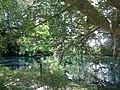
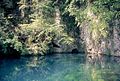
The route over the Alps cites several resurgences and springs over, the particularly strong pour in spring: Kocherursprung , pepper origin and Brenz origin .

The black cooker at Oberkochen
The red cooker , also at Oberkochen

The origin of the white cooker at Unterkochen
The stew pot west of Königsbronn
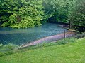
The pepper spring east of Königsbronn


Culture
In the first part, the path connects some churches with carvings by Tilman Riemenschneider : Würzburg, Ochsenfurt, Aub, Creglingen, Detwang , Rothenburg ob der Tauber.
The route through Upper Swabia also reaches some stations on the Upper Swabian Baroque Road : Oberelchingen, Wiblingen (requires a short detour), Ochsenhausen, Bad Waldsee (the core city requires a short detour), Wolfegg and Tettnang.
Image gallery of baroque art along the way

Wiblingen Monastery Church

Baroque library of the Benedictine Abbey of Wiblingen

Large baroque organ in the church of St. Georg von Ochsenhausen

Knight's Hall in Wolfegg Castle


Others
The Heidenheim – Langenau stage is 31 kilometers long. The only place to stop for refreshments en route is the “Lonetal” motorway service station on the A 7 . The way passes the supplier approach to this rest stop, through which one reaches the guest rooms.
literature
- Willi Beck: HW 4 Main - Danube - Lake Constance. , Konrad-Theiss-Verlag, Stuttgart 1983, ISBN 3-8062-0330-X . Available from the Swabian Alb Association .
Web links
- Main hiking trail 4 at the Swabian Alb Association
HW 1: Swabian Alb North Edge Path | HW 2: Swabian Alb South Rim Trail | HW 3: Main-Neckar-Rhein-Weg | HW 4: Main-Danube-Bodensee-Weg | HW 5: Black Forest-Swabian-Alb-Allgäu-Weg | HW 6: Limes hiking trail | HW 7: Swabian-Alb-Upper Swabian Way | HW 8: Frankenweg | HW 9: Heuberg-Allgäu-Weg | HW 10: Stromberg-Swabian Forest Path | Georg-Fahrbach-Weg (GFW) | Württemberg Wine Trail (WWW) | Neckarweg | Lake Constance circular route | Main-Danube-Way | Upper Swabian Way of St. James | Franconian-Swabian Way of St. James