
Black cooker
| Black cooker | ||
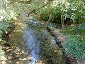
 The black cooker shortly after its origin |
||
| Data | ||
| Water code | EN : 2386 | |
| location |
Swabian Alb
|
|
| River system | Rhine | |
| Drain over | Kocher → Neckar → Rhine → North Sea | |
| source | with Oberkochen in the cooker origin 48 ° 46 ′ 20 ″ N , 10 ° 5 ′ 43 ″ E |
|
| Source height | 499.2 m above sea level NN | |
| Spring discharge |
MNQ MQ MHQ |
50 l / s 680 l / s 4 m³ / s |
| confluence | when undercooking with the white cooker to the cooker coordinates: 48 ° 49 ′ 13 ″ N , 10 ° 7 ′ 9 ″ E 48 ° 49 ′ 13 ″ N , 10 ° 7 ′ 9 ″ E |
|
| Mouth height | approx. 450 m above sea level NN | |
| Height difference | approx. 49.2 m | |
| Bottom slope | approx. 6.4 ‰ | |
| length | 7.7 km | |
| Catchment area | 37.961 km² | |
| Discharge at the water junction level “above Weißer Kocher” A Eo : 37.86 km² |
MNQ MQ Mq MHQ |
287 l / s 1.062 m³ / s 28.1 l / (s km²) 6.99 m³ / s |
| Small towns | Oberkochen | |
The black cooker is the left, longer source flow of the cooker . It rises south of Oberkochen from the origin of the Kocher . When undercooking , it combines with the white cooker to form the cooker .
Surname
Since the source river flows quietly away from its source, the viewer has the impression that it is black. This led to the name Schwarzer Kocher. Another explanation is that slag residues from the former slag laundry near the origin of the cooker gave the black cooker its name.
Historical maps, namely the Walch map from 1804 and the Majersche map from 1705, show, however, that the names of the source rivers of the Kocher were exchanged over time. There the Oberkochen tributary, today's black cooker, is referred to as the “red boiler” and the Unterkochen tributary, today's white boiler , is called the “black cooker”.
geography
course
The origin of the Black Kocher south of Oberkochen is the start and end point of the Oberkochen route of the Karstquellenweg .
The Schwarze Kocher flows through the town of Oberkochen, where the third and smallest source brook of the Kocher, the Rote Kocher , flows from the oil pond. It is also fed by the Katzenbach . This rises in the meadow from a typical layer boundary spring . The Katzenbach flows, partly piped, after a short run as Zollbach at the station bridge into a Mühlkanal next to the Schwarzer Kocher. About half a kilometer down, the Gutenbach , also known as Langertbach , also flows into the same canal in the settlement area of the city, a few steps before its return .
In the Aalen district of Unterkochen, the black and the white cooker unite . The confluence was renatured in 2015 and relocated about 100 m to the northeast. Where the Black Kocher flows to the east today, the White Kocher ran west until the redesign.

Tributaries
- Red cooker ( left )
- Katzenbach ( left )
- Gutenbach , also called Zollbach in the lower part ( left )
- Edlenbach ( right )
See also
Picture gallery

The black cooker shortly after its origin

The black cooker in front of Oberkochen
Earlier confluence of the Black Kocher (left) and the White Kocher (right) in Unterkochen before renaturation

Place of the earlier confluence today


literature
- Bernhard H. Lott: The cooker from the source to the mouth. Künzelsau 2002. ISBN 3-934350-80-1 .
Web links
- www.aalen.de - Tourist information
- www.brenzbahn.de - Kocher Geology
- www.kochertal.net - the lifeline of the Ostalbkreis
Individual evidence
- ↑ Hansjörg Dongus : Geographical land survey: The natural spatial units on sheet 171 Göppingen. Federal Institute for Regional Studies, Bad Godesberg 1961. → Online map (PDF; 4.3 MB)
- ↑ State Institute for the Environment Baden-Württemberg (LUBW) ( information )
- ↑ Abfluss-BW - a data and map service of the State Office for the Environment Baden-Württemberg ( information ). Acquired on April 8, 2016
- ↑ Dietrich Bantel: Schwarzer Kocher was Roter Kocher . In: Citizens and Community. Official journal of the city of Oberkochen . 57th year, No. 2, January 15, 2010, p. 29.