
Karst Quellenweg
| Karst Quellenweg | |
|---|---|

|
|
| overall length | 28.6 km |
| location |
|
| Starting point | a) Königsbronn am Brenztopf b) Oberkochen at the origin of the stove |
| Target point | The respective starting point |
| Places along the way | Königsbronn , Oberkochen |
| Flooring | paved roads |
| Height difference | 495 - 590 m above sea level NHN |
| difficulty | light |
| Traffic volume | mostly very low |
| Website URL | a) Karstquellenweg on koenigsbronn.de b) Karstquellenweg on oberkochen.de |
The Karstquellenweg near Oberkochen and Königsbronn is an almost thirty-kilometer-long nature trail in Baden-Württemberg that leads through the adjoining source areas of Kocher and Brenz .
History of origin

The path was created on the initiative of the city of Oberkochen and the municipality of Königsbronn in order to set up an educational trail for the production and supply of drinking water in the Eastern Alb and to open up the various springs in their districts for tourism. The road planning was carried out by the Oberkochen State Forestry Office and the Swabian Alb Association . On April 27, 1989, the nature trail, which was mainly built with funding from the state of Baden-Württemberg , was opened to the public. It is under the care of the Swabian Alb Association.
The two signposted routes connect the most important water breaks at fifteen stations in the upper Kocher and Brenz valleys. They lead across the European main watershed , which runs between the Brenztopf in Königsbronn and the origin of the Kocher in Oberkochen. The stations are described with information boards. These boards and the small signposts can be recognized by the coat of arms of Oberkochen and the coat of arms of Königsbronn . The numbers given below refer to the map shown.
Karst springs
Karst landscapes have a water-permeable surface through which the water from rainfall and snowmelt seeps into underground caves and passages. From there it flows on and finally emerges at karst springs .
It is the same on the karstified Alb plateaus of Albuch and Härtsfeld , which rise to the west and east of Oberkochen and Königsbronn. Up there there are almost no streams or rivers because most of the rainwater seeps away and reappears in numerous karst springs down in the valley in the area of the Kocher and Brenz origins.
Königsbronn route
The Königsbronn route is 11.7 kilometers long. Your stations are in the headwaters of the Brenz , whose water flows south to the Danube and then into the Black Sea .
Stew pot (1)
The route begins at the Brenztopf at 500 m above sea level. NHN at the town hall of Königsbronn, where there are parking spaces.
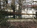
Itzelberger See (2)
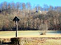
Via Herwartstraße and Itzelberger Straße it goes to Itzelberg to Itzelberger See at 496 m above sea level. NHN. It was originally created as a fish pond by the Cistercian monks from the former Königsbronn monastery . Today the approximately 6.5 hectare reservoir is a local recreation area. The bird protection island is an important habitat for flora and fauna .
Itzelberg waterworks (3)
The main pumping station of the administration union Härtsfeld-Albuch water supply to 595 m above sea level. NHN was built in 1892 and pumps its water from three deep wells in the Brenzaue between Königsbronn and Itzelberg. The karst water is pumped with the help of a turbine fed by water power from the lake onto the plateaus of Härtsfeld and Albuch and supplies over 25,000 residents with up to 5000 m³ of drinking water per day. An iron forge stood here in 1479 and a tinsmith's shop from 1591 to 1869. The cast iron fountain, restored in 1991, is a reminder of the communities that founded the association in 1890.
Source of Pepper (4)
The source of the pepper is in Frauentalstrasse behind the foundry at 505 m above sea level. NHN.
Empty source (5)
The Leerausquelle further north in Frauentalstrasse is 515 m above sea level. NHN and only carries water after snowmelt and heavy rainfall. Otherwise it “comes out empty”.
European watershed (6)
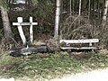
The main European watershed separates the catchment areas from the Rhine which flows into the North Sea and the Danube which flows into the Black Sea . It runs 350 meters north of the Seegartenhof at 507 m above sea level. NHN across the breakthrough valley of the Urbrenz . A sign on federal road 19 in the direction of Königsbronn informs about the “European watershed”, but is set up almost 700 meters too far south.
Ziegelbach Spring (15)
At the Ziegelhütte rises at 506 m above sea level. NHN the Ziegelbach .
Stew pot (1)
Back at the starting point.

Stew pot

Itzelberger See

Itzelberg waterworks
Source of pepper

Empty source
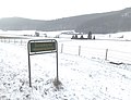
Sign pointing to the European main watershed on Bundesstrasse 19
Ziegelbachquelle


Oberkochen route
The Oberkochen route is 16.9 kilometers long. With the exception of the Ziegelbach spring, your stations are in the source area of the Kocher , whose water flows north to the Neckar and then into the Rhine and North Sea .
Cooker Origin (13)
The route begins at 499 m above sea level. NHN at the origin of the Black Cooker south of Oberkochen, where there is a parking lot for hikers. After the Thirty Years' War there was a slag washing plant here .
Langert Fountain (7)
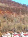
Along trout farms, the neo-Romanesque church of St. Peter and Paul, Scheerermühle, the Reconciliation Church and the town hall, you go into Wolfertstal. There rises at 529 m above sea level. NHN the Langertbach, which flows into the Gutenbach after a few meters . There is a water playground with a water treading facility that was built on a private initiative in the 1980s. The Langertbrunnen is also called the battle source.
The rock above the Langertbrunnen is the Langertstein (→ Lage) . It can be reached via a narrow and sometimes very steep hiking trail that leads past the field cross and offers at 610 m above sea level. NHN a view of the Wolferts and Kocher valleys. In the west wall of the rock is the entrance to the Langertstein cave, the passage of which leads about ten meters into the rock. From Langertstein you can return to the valley on comfortable gravel paths past the Obere Schlachtquelle.
Upper Battle Spring (7a)
Five hundred meters up the valley lies at 590 m above sea level. NHN the Upper Battle Spring . It irrigates the slaughterhouse all year round . The water flowing out of the shell seeps away just below it.
Hunger Well (8)
The hunger well in Wolfertstal is 525 m above sea level. NHN the origin of the Gutenbach . After the snowmelt and heavy rain, the water gushes from numerous springs in the middle of the meadow. Eichertbrünnele is located 1.3 kilometers up the valley in the direction of Essingen , from whose area the hunger well receives additional surface water after rain and snowmelt.
New Well (9)
The formerly open fountain at 520 m above sea level. NHN, whose water flows laterally into the Gutenbach, is not signposted and there is nothing special to see there.
Luggenloh Fountain (10)
The version of the Luggenloh fountain at 508 m above sea level. With up to 450,000 m³ per year, NHN supplies half of Oberkochen's drinking water requirements. The catchment area is completely forested and always provides perfect water, which, however, has a high water hardness due to the limestone .
Katzenbach spring (11)
The source of the Katzenbach at 518 m above sea level. NHN rises southwest of the municipal cemetery.
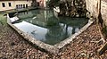
Oil Pond (12)
The oil pond is the source of the red cooker and lies at 500 m above sea level. NHN in a not freely accessible park on the premises of the company Leitz GmbH & Co. KG . It is fed from several sources and is the origin of the red cooker, which is piped from the pond and then flows into the black cooker after 150 meters.
European watershed (6)
Before crossing Bundesstraße 19 , you cross the European main watershed . It runs 350 meters north of the Seegartenhof at 507 m above sea level. NHN across the Urbrenz breakthrough valley and separates the catchment areas of the Rhine that flows into the North Sea and the Danube that flows into the Black Sea .
Ziegelbach Spring (15)
At the Ziegelhütte rises at 506 m above sea level. NHN the Ziegelbach , which flows into the Brenz.
Tiefental (14)
The five kilometer long Tiefental, also known as the Tiefes Tal , is a dry valley. 2.5 kilometers up the valley rises at 570 m above sea level. NHN the never-ending Hubertus spring . This feeds a small pond. The water flowing off there seeps away after a few hundred meters. According to the information board , this water should escape from the Flein spring at the lower end of the valley when the water level is high . However, there is no evidence of such a source at the lower end of the valley. The deep valley drains superficially into the Kocher, but deep down into the Brenz.
Cooker Origin (13)
Back at the starting point.

Cooker origin

Langert fountain with water playground
Langertstein

Upper battle source

In the hunger well, the water gushes out of the meadow in various places

At the new well

Luggenloh fountain

Katzenbach spring
Oil pond
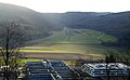
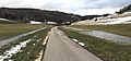
Tiefental, in the foreground the industrial area Oberkochen Süd I


More karst springs

The following karst springs are not on the Karstquellenweg:
Hubertus spring
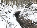
In the Tiefental, whose confluence with the Urbrenztal lies on the Karstquellenweg, the never-ending Hubertus spring rises 2.5 kilometers up the valley . Their water feeds a 15-meter-wide spring pond a few meters from the source. The water that runs off in a narrow stream seeps away after a few hundred meters in the karst gravel bed of the Tiefental.
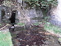
Well source
The spring of the fountain rises in the slope of the fountain dump above the Zeppelinweg (→ location) in the middle of the forest and is difficult to access. The water from this spring, which is not very productive even after the snow has melted, initially flows steeply downhill in a gentle serpentine line to a hiking trail. From there it flows with a slight gradient in a channel next to the hiking trail in a northerly direction to the hiking car park and there disappears into the sewer system.
Forty meters above the fountain source is the fountain cave (→ location) . Your entrance is at the foot of the Brunnenstein, an inconspicuous rock above a steep lumber path. With a length of 145 meters, it is the longest cave in the Ostalb district . In 1977 and 1978 a small cave stream and two cave lakes with very rich stalactite deposits were discovered. The cave passages were created millions of years ago by a larger cave stream, which widened the fissures in the White Jurassic limestone banks. The well cave is a protected natural monument.
Eichertbrünnele
This wooden fountain is located 1.3 kilometers up the valley from the Hungerbrunnen on the way to Essingen (→ Lage) in Wolfertstal . After heavy rainfall and after the snow has melted, considerable amounts of surface water flow from the area of this well in two streams to the left and right of the path to the hunger well.
Edlenbach spring
The Edlenbach rises east of Oberkochen on the grounds of the nursery in the long pond . After 700 meters, it flows into the Schwarzer Kocher near the building at Kreuzmühle 18. It is its last tributary in the Oberkochen district and the only one that flows into it from the right Härtsfeld side.

Hubertus spring
Brunnenstein above the Zeppelinweg. The spring of the fountain is forty meters below the rock.

Well stone with entrance to the well cave directly behind the front piece of rock

Entrance to the well cave
Well source

The stream of the fountain source above the hiking trail
Eichertbrünnele
After the snowmelt, two streams flow from the Eichertbrünnele to the Hungerbrunnen

Edlenbach spring


See also
- List of the tributaries of the stove
- List of tributaries of the Brenz
- List of karst springs in Baden-Württemberg
Web links
- Karstquellenweg on oberkochen.de
- Karstquellenweg on koenigsbronn.de
Individual evidence
- ↑ 1980 - The Volkmarsbergturm a "fifty"! on albverein-oberkochen.de.
- ↑ Hans-Joachim Bayer: Karstquellenweg Oberkochen – Königsbronn , in sheets of the Swabian Alb Association No. 4, 1990, p. 102ff.
- ↑ Geotope profile (PDF, 359 KByte) on: Map server of the State Office for Geology, Raw Materials and Mining (LGRB) ( information )
- ↑ Hans-Joachim Bayer: The well cave. From the burrow to the longest cave in the Ostalb district. in: Ostalb-Einhorn, issue 26, June 1980.
- ↑ Geotope profile (PDF, 359 KByte) on: Map server of the State Office for Geology, Raw Materials and Mining (LGRB) ( information )