
Edlenbach
| Edlenbach | ||
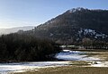
 Source of the Edlenbach |
||
| Data | ||
| location |
Albuch and Härtsfeld
|
|
| River system | Rhine | |
| Drain over | Schwarzer Kocher → Kocher → Neckar → Rhine → North Sea | |
| source | in Oberkochen Won "Long Pond" 48 ° 47 '7 " N , 10 ° 7' 46" O |
|
| Source height | approx. 510 m above sea level NHN | |
| muzzle | from the right in the Schwarzen Kocher coordinates: 48 ° 47 '25 " N , 10 ° 7' 29" E 48 ° 47 '25 " N , 10 ° 7' 29" E
|
|
| length | approx. 700 m | |
The Edlenbach is a right tributary of the Schwarzen Kocher in Oberkochen in the Ostalb district .
course
![]() Map with all coordinates of the item: OSM | WikiMap
Map with all coordinates of the item: OSM | WikiMap
The Edlenbach rises in a karst spring in the Oberkochen Gewann "Langenteich" on the site of the local "Härtnerei im Langen Teich". It crosses under the narrow street that runs along the nursery and then flows in a north-westerly direction to the federal highway 19 and the district road K3292, which lead from Oberkochen to Unterkochen .
Before it reaches the main road, the Edlenbach flows through a dense undergrowth, if it has not already drained away on the way there. There the Erlenbach rises in a Hülbe ( Erlenbach source ) and flows into the Edlenbach ( mouth Erlenbach ) after about twenty-five meters from the right . Since this short branch is the more productive of the two streams at certain times, the Edlenbach - at least in the lower reaches - is sometimes equated with the Erlenbach and referred to as the Erlenbach.
After a piped section to cross under the two streets and the railway line running parallel to them, the Edlenbach, which is united with the Erlenbach, covers the remaining meters above ground. After a total of about 700 meters, it flows into the Schwarzer Kocher near the building at Kreuzmühle 18.
The Edlenbach is the last tributary of the Schwarzen Kocher in the Oberkochen district and the only one that flows into it from the right Härtsfeld side.
history
In Roman times , the Edlenbach spring was probably a reason to build a rest stop with a small bath there. It was located on the Roman road that led from the south through the Brenz-Kochertal to the Reiterkastell Aalen , which served to protect the nearby Limes . 1971 there (dug Römerkeller ) students of the local high school under expert guidance the foundations of a Roman cellar from the 2nd or 3rd century AD, the one originally part of a villa rustica held.

Source of the Erlenbach

The Erlenbach flows from above into the Edlenbach, which flows from right to left below

Mouth of the Edlenbach coming from above in the picture into the Black Kocher coming from the right
In this water protection area, the Erlenbach flows into the undergrowth in the foreground into the Edlenbach coming from the left, which then flows under the B 19 and further to the right into the Kocher

Excavated cellar of a Roman rest stop
_Quelle.jpg)
_M%C3%BCndung.jpg)


See also
Individual evidence
- ↑ Contour map of the SAV "Aalen Härtsfeld Heidenheimer Alb"
- ↑ Appreciated on Google Maps
- ^ Dietrich Bantel: News from the Romans in Oberkochen. Römerkeller is not »Villa Rustica« but a street station. Kocher origin = Roman spring sanctuary? on heimatverein-oberkochen.de. Retrieved January 21, 2019.