Undercooking
|
Undercooking
City of Aalen
|
|
|---|---|
| Coordinates: 48 ° 49 ′ 0 ″ N , 10 ° 7 ′ 35 ″ E | |
| Height : | 460 m |
| Area : | 21.45 km² |
| Residents : | 5104 (Jul. 1, 2019) |
| Population density : | 238 inhabitants / km² |
| Incorporation : | 1st January 1973 |
| Postal code : | 73432 |
| Area code : | 07361 |
|
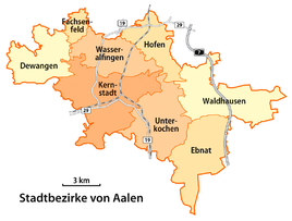
Map of the Aalen districts (Unterkochen in the south)
|
|
|
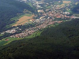
Undercooking from the air
|
|
Unterkochen is an industrial district of the large district town of Aalen in the Ostalb district in Baden-Württemberg ( Germany ).
geography
Unterkochen is located in the Kocher Valley on the edge of the Swabian Alb . The place is surrounded to the west by the slopes of the Albuch and east by the Härtsfeld .
The district of Aalen-Unterkochen has an area of 2145 ha, of which only about 6% are built on. The rest is divided into forest areas (approx. 74%), agricultural areas (approx. 14%) and other areas (approx. 6%).
Neighboring communities
Neighboring communities are south along the B 19 Oberkochen , north Aalen . In addition, the Aalen district of Ebnat lies in the east on the Härtsfeld plateau . The district of Unterkochens borders on two other city districts, Waldhausen in the northeast and Hofen in the north .
Urban district structure
The city district includes the districts of Unterkochen, Birkhöfe, Glashütte, Neukochen, Neuziegelhütte, Pulvermühle and Stefansweiler Mühle.
Spatial planning
As a city district, Unterkochen is embedded in the middle center of Aalen within the East Württemberg region .
history
Unterkochen was first mentioned around 1136 as "Cochon". The settlement was built around a castle ("Kocherburg"), which was mentioned as early as 1300, but was rebuilt in 1627 and destroyed in 1645 by the Swedes. Today only remnants of the wall remain. The owners were originally the Lords of Cooking Castle, followed by those of Ahelfingen and, in 1317, those of Öttingen before the town came to Ellwangen . The Kocherburg then became the seat of the Obervogts of the Ellwang Oberamt Kocherburg. After the castle was destroyed, they resided in a newly built office building. The Malse family had further property in the village until 1465, whose property also fell to Ellwangen. Ore mining was carried out in the village from 1518 as well as in neighboring Oberkochen. The ore was smelted by Württemberg from 1557 . In 1614, however, Württemberg had to sell his works to Ellwangen. After the transition to Württemberg in 1802, the plant was closed and relocated to Wasseralfingen . Until 1877 the Württemberg camera office was housed in the former administrative building. At the time of the Kingdom of Württemberg Unterkochen belonged to the upper office Aalen , which in 1934 renamed the county Aalen and in the extended 1938 County Aalen was transferred. On January 1, 1973, Unterkochen was incorporated into the city of Aalen.
Religions
The Catholic pilgrimage church of St. Maria Unterkochen was first mentioned in 1248 and the parish was also responsible for the Catholics in Aalen for a long time. Even today, the majority of the people of Unterkochen belong to the Roman Catholic Church (approx. 56%), a further 21% are Protestant. The remaining 23% are mainly members of Islam and people who do not provide any information.
Population development
|
|
politics
Local council
The local council of the district of Unterkochen currently has 14 members whose term of office is five years. The last election took place in the Baden-Württemberg municipal elections on May 26, 2019. This resulted in the following composition (the changes in parliamentary groups refer to the penultimate election in 2014):
| fraction | Number of seats | change |
|---|---|---|
| SPD | 4 seats | −1 |
| CDU | 4 seats | −1 |
| FW undercooking | 3 seats | −1 |
| GREEN | 3 seats | +3 |
Head of town
Heidemarie Matzik of the SPD has been the head of the district of Unterkochen since 2014.
coat of arms
The coat of arms of Unterkochen shows three white, five-spoke wheels in a red shield. The colors of the borough, red and white, can also be derived from this. It goes back to the Lords of Boiling, who were first mentioned in 1136 and carried this coat of arms until 1475, when they became extinct. However, the coat of arms has been retained until today.
Economy and Infrastructure
traffic
- train
- The district of Unterkochen is located on the Brenzbahn Ulm – Aalen. There is one train every hour to Ulm via Oberkochen, Heidenheim / Brenz and Giengen / Brenz as well as to Aalen. Sidings have the state in 2014, the company Palm paper mill and Munksjö Paper.
There is a north-south connection via federal highway 19 .
- air traffic
- Stuttgart international airport in Leinfelden-Echterdingen can be reached in 90 minutes by car or by train (direct S-Bahn connection from Stuttgart main station ). The city of Aalen has the small Aalen-Heidenheim airfield near Elchingen .
- bus
- The city district is served by two OVA city bus lines and several lines from various bus companies
Established businesses
Paper processing dominates in Unterkochen ( Palm paper factory ). In addition to this, the metal processing and textile industries are important carriers of the economic structure.
media
Unterkochen is in the circulation area of the daily newspapers Schwäbische Post , a local edition of the Südwestpresse and the Aalener Nachrichten , a local edition of the Schwäbische Zeitung . In addition, there is a weekly edition of the Kocherburgbote , the newsletter of the Aalen-Unterkochen district.
Public facilities
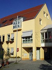
Unterkochen is the seat of a district office that is the point of contact for all aspects of municipal services in the district.
education
schools
- Peace school
- Kocherburg School
Kindergartens
- Catholic Kindergarten St. Josef
- Catholic Kindergarten Maria-Fatima
- Evangelical kindergarten treasure chest
Personalities
Honorary citizen
- Georg Kollmann (1820–1903), Dean
- Hans Meinzinger (1895–1970), director
- Adolf Palm (1846–1925), paper manufacturer
- Otto Palm (1882–1961), paper manufacturer
- Bruno Arthur Tugendhat (1870–1957), General Manager
- Philipp Wöhr (1877–1961), manufacturer
Sons and Daughters of the Borough
- Karl Joseph von Hefele (1809–1893), Roman Catholic church historian, third bishop of the Rottenburg-Stuttgart diocese
- August Harlacher (1842–1907), German tenor and opera director
- Albert von Berrer (1857–1917), Lieutenant General
- Adolf Kling (1893–1938), politician (NSDAP)
- Hermann Weber (1902–1976), pastor and local history researcher
- Hans Seibold (1904–1974), politician (NSDAP)
- Georg Sternbacher (1933–1995), painter
- Michael Russ (* 1945), concert organizer
- Patrick Funk (* 1990), soccer player
- Marius Funk (* 1996), soccer player
Culture and sights
Buildings
Pilgrimage Church of St. Mary
From all directions the view is captured by the dominant location of the Kirchberg and its harmoniously integrated building ensemble, which is crowned by the pilgrimage church. The first documentary mention was in 1465. In terms of style, the church dates from different epochs, the tower is from the Romanesque, the choir from the Gothic and the nave by Johann Michael Keller from the Baroque period. In the high altar is a life-size statue of the Virgin Mary, a masterpiece of the Ulm School, created around 1496, the image of miraculous grace in Unterochen, to which pilgrimages have led for centuries.
The statue of the third bishop of Rottenburg Karl Joseph von Hefele , in the front left of the nave, was erected on May 30, 1897. Hefele was born on March 15, 1809 in the Hochmühle near Unterkochen, was Professor of Church History (Councils) at the University of Tübingen and from 1869 to 1893 Bishop of Rottenburg.
Cooker origin
Unterkochen springs from the White kettle . In the center he joins the from Oberkochen coming Black kettle for making facilities .
Kocherburg ruins
The Kocherburg on a spur of the plateau above the outskirts is an important archaeological cultural monument with its fortifications. Excavations revealed evidence of an already prehistoric settlement. In 1645, the "Cooking Castle" was shot down by the Swedes and then not rebuilt; the rubble remained or the stones were used to build buildings in the village. An archaeological tour leads through and around the ruin.
Hollow stone
A slope rises steeply from the Glashütte district. At its height there is a rock that arches into a cave. The Hohle Stein is the best-known and most legendary cave in Unterkochen next to the palace construction site on which the Kocherburg once stood. The Hohle Stein is a spacious rock cave that is complemented by two cave chimneys and a long, very shallow cave passage.
viaduct
The historic building from 1901 was built for the newly built route of the Härtsfeldbahn , the so-called Schättere. The viaduct is over 70 meters long and 25 meters high. In 1972 the railway operation was stopped after more than 70 years. Today a well-developed hiking trail leads over the viaduct, which was completely renovated in 2003 and 2004.
Sports and clubs
In the Häselbachstadion with a grass pitch and an artificial turf pitch, the FV 08 Unterkochen (season 2019/2020 district league East Württemberg) plays its home games. The sports field at the origin of the Kocher is used as a training ground with the neighboring tennis facility (SV Unterkochen). There is also a multi-purpose sports hall for events and sports of all kinds, the adjoining new festival hall, a gymnastics hall and a pétanque facility.
There are seven sports clubs and a further 13 clubs in the fields of culture, business, church and social affairs.
literature
- Karlheinz Bauer: Unterkochen - The home book of the district of Unterkochen, Aalen 1989.
Regular events
Every year in June, the "Unterkochen Bear Days", known beyond the city limits, take place on Rathausplatz, which in 2012 replaced the "Unterkochen Summer Days" at the origin of the Kocher.
Individual evidence
- ^ Federal Statistical Office (ed.): Historical municipality directory for the Federal Republic of Germany. Name, border and key number changes in municipalities, counties and administrative districts from May 27, 1970 to December 31, 1982 . W. Kohlhammer, Stuttgart / Mainz 1983, ISBN 3-17-003263-1 , p. 445 .
- ↑ election result AA_OR Unterkochen 2014 , aalen.de, accessed on July 11, 2014.
- ↑ Train drivers leave Mugele containers behind , Gmünder Tagespost, article from November 7, 2014


