
Itzelberger See
| Itzelberger See | ||
|---|---|---|

|
||
| View of the north bank of the Itzelberger See | ||
| Geographical location |
Baden-Württemberg
|
|
| Tributaries | Brenz | |
| Drain | Brenz → Danube → Black Sea | |
| Places on the shore | Itzelberg | |
| Location close to the shore | Königsbronn , Heidenheim | |
| Data | ||
| Coordinates | 48 ° 43 '57 " N , 10 ° 8' 1" E | |
|
||
| Altitude above sea level | 495.6 m above sea level NHN | |
| surface | 0.084 | |
| Maximum depth | 3 m | |

The Itzelberger See in a lake near Itzelberg , a district of the municipality of Königsbronn in the district of Heidenheim at the eastern end of the Swabian Alb in the east of Baden-Württemberg .
geography
The lake is created by the damming of the Brenz . This river has its source 1.2 kilometers above in the Brenztopf . At the inlet of the Brenz there is a wet biotope with a bird protection island. A circular hiking trail leads around the lake. The Itzelberger See is station no. 2 on the Königsbronn route of the Karstquellenweg .
history
The Itzelberger See was probably dammed in the 14th century by the Cistercian monks from the former Königsbronn monastery in order to make better use of the water power and to be able to farm fish. Between 1471 and 1479 they set up an iron forge here.
After its destruction in the Thirty Years War , reconstruction began in 1696. The operation consisted of a hammer forge with two ringing fires, a large hammer and a stretching and zain hammer, two coal scrubbers and a sawmill. The drained lake was refilled.
On a map in the lake atlas by JA Riediger 1737/38 you can see not only the hammer forge at the outflow of the lake, but also a "shooting gallery" which was used to hunt birds.
Itzelberg was closely interlinked with the ironworks in Königsbronn until the 19th century , until gradually all production facilities were relocated to the new parent plant (today SHW Casting Technologies ).
The main pumping station of the administration union Härtsfeld-Albuch water supply to 595 m above sea level. NHN was built in 1892 and pumps its water from three deep wells in the Brenzaue between Königsbronn and Itzelberg. The karst water is pumped with the help of a turbine fed by water power from the lake onto the plateaus of Härtsfeld and Albuch and supplies over 25,000 residents with up to 5000 m³ of drinking water per day. The cast iron fountain, restored in 1991, is a reminder of the communities that founded the association in 1890. The waterworks is station no. 3 on the Königsbronn route of the Karstquellenweg .
To the north of the lake there is a quarry where the White Jura was previously mined. There the resistance fighter Georg Elser stole the dynamite for his failed bomb attack on Adolf Hitler in 1939 .
Landscape protection area
In 1957 the lake was de-silted because a two-meter-thick layer of mud had collected and the water level was sometimes only thirty centimeters deep. At that time, more than 170,000 cubic meters of sludge were removed from the lake basin and a large part of the marsh meadows were filled with the dredged sludge. Only two hectares of the former moor remained , from which the bird protection island was formed as a breeding and retreat area for birds and amphibians. To the north of the bird protection island there are two so-called moss ponds .
Itzelberger See has been a protected landscape area since 1978 . One finds there kingfishers , mallards , tufted ducks , moorhens , mute swans , coots , Canada geese , and herons . In the winter months raced among other Pochard , Pochards and gulls on the lake, and then travel further in the spring in their breeding grounds.
All important Central European fish species such as eel , grayling , brown trout , brook trout , bream , chub , pike , carp , rainbow trout and rudd can be found in the lake, which is considered to be rich in fish .
Since a boat and raft rental company went into operation in 2012 , a floating barrier has separated the tourist part of the lake from the bird island.
Recreation area
The Itzelberger See is not used as a bathing lake. Boat and raft rental, mini golf course and pit-pat facility on the south bank are limited to the season from March to October. A restaurant and a children's playground on the south bank are open all year round.
The lake is managed by the State Fisheries Association of Baden-Württemberg eV as fishing waters .

Itzelberger See in the lake atlas by JA Riediger 1737/38

Western tip of the bird protection island at the Brenz inlet

Water birds on the north bank

Waterworks of the Härtsfeld-Albuch water supply on the east bank
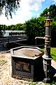
Cast iron fountain at the waterworks
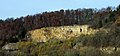
Former quarry north of the lake


See also
Web links
Individual evidence
- ↑ Karstquellenweg on koenigsbronn.de.
- ↑ a b c Itzelberger See on koenigsbronn.de.
- ↑ a b c Itzelberger See on monsterfisch.de.
- ↑ Manfred Thier: History of the Swabian Hüttenwerke. A contribution to the economic history of Württemberg. 1365-1802. Aalen / Stuttgart 1965, p. 8.
- ↑ Thier p. 175.
- ^ A b Gerhard Stock: Plans for “large-scale catering” on Lake Itzelberger See . In: Heidenheimer Zeitung from October 13, 2018.