Rettenbach (Sankt Englmar)
|
Rettenbach
Sankt Englmar parish
Coordinates: 48 ° 58 ′ 24 ″ N , 12 ° 51 ′ 5 ″ E
|
|
|---|---|
| Height : | 718 m |
| Residents : | 89 (May 25 1987) |
| Postal code : | 94379 |
| Area code : | 09965 |
|
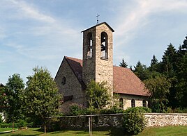
The branch church of St. Wolfgang
|
|
The church village of Rettenbach is a district and a district of the municipality of Sankt Englmar in the Lower Bavarian district of Straubing-Bogen .
location
The touristic place is located at the foot of the Hirschenstein at an altitude of 725 meters about five kilometers south-east of Sankt Englmar. Rettenbach is important as a starting point for hikes to the Hirschenstein.
history
Mentioned in 1305 as the property of Windberg Monastery , Gut Schmelmerhof has been family- owned since 1630. The Romantik Hotel Gut Schmelmerhof was opened in 1967 and has 52 rooms and suites as well as a vaulted restaurant from 1864. Other tourist offers include the Fuchshof , which has been in the family since 1665, and the Landgasthof Hotel Zum Hirschenstein . The St. Wolfgang branch church was built in 1953 by Hans Beckers . Next to it is the cemetery laid out by Adolf Neuhofer.
In the vicinity of Rettenbach, BMW planned to set up a 5.22 hectare driver training area for off-road vehicles, which was to be spun off from the Bavarian Forest Nature Park . The project was approved by the district council in 2005. Although the necessary aisles had already been made, BMW abandoned the project in 2007 following criticism from environmental and nature conservationists.
Web links
- Rettenbach in the local database of the Bayerische Landesbibliothek Online . Bavarian State Library
Individual evidence
- ↑ Bavarian State Office for Statistics and Data Processing (Ed.): Official local directory for Bavaria, territorial status: May 25, 1987 . Issue 450 of the articles on Bavaria's statistics. Munich November 1991, DNB 94240937X , p. 240 ( digitized version - "Rettenbach, Kd .; population at the place of the Hauptw.:89; building with living space: 29; apartments: 34;" (in table form)).
