Rattiszell
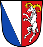
| coat of arms | Germany map | |
|---|---|---|

|
Coordinates: 49 ° 1 ′ N , 12 ° 40 ′ E |
|
| Basic data | ||
| State : | Bavaria | |
| Administrative region : | Lower Bavaria | |
| County : | Straubing arch | |
| Management Community : | Stallwang | |
| Height : | 363 m above sea level NHN | |
| Area : | 22.19 km 2 | |
| Residents: | 1492 (Dec. 31, 2019) | |
| Population density : | 67 inhabitants per km 2 | |
| Postal code : | 94372 | |
| Area code : | 09964 | |
| License plate : | SR , BOG, MAL | |
| Community key : | 09 2 78 179 | |
| LOCODE : | DE RT3 | |
| Community structure: | 37 districts | |
| Association administration address: | Straubinger Str. 18 94375 Stallwang |
|
| Website : | ||
| Mayor : | Manfred Reiner ( Free Voters ) | |
| Location of the municipality of Rattiszell in the Straubing-Bogen district | ||
Rattiszell is a municipality in the Lower Bavarian district of Straubing-Bogen and a member of the Stallwang administrative community .
geography
Rattiszell is located in the Danube Forest region in the Bavarian Forest . The main town of Rattiszell is located in the Kinsach valley between Pilgramsberg ( 619 m ) and Gallnerberg ( 709 m ).
Community structure
Rattiszell has 37 districts:
There are the districts Eggerszell, Haunkenzell, Herrnfehlburg, Pilgramsberg and Rattiszell.
history
Until the church is planted
Rattiszell belonged to the Lords of Buchätt. The place was part of the Electorate of Bavaria and formed a closed Hofmark , whose seat was Rattiszell. In the course of the administrative reforms in Bavaria , the municipality of Rattiszell was created with the municipal edict of 1818 .
Incorporations
Herrfehlburg was incorporated as early as 1927. In 1946 parts of Eggerszell followed.
Until the municipal reform, Rattiszell was part of the Bogen district, which was dissolved in 1972 . On May 1, 1978 Haunkenzell was incorporated, which had incorporated Maiszell in 1876 and parts of Pilgramsberg and Eggerszell in 1946. The hamlet of Straßhäuser only became an independent district after 1987.
Population development
In the period from 1988 to 2018, the municipality grew from 1289 to 1489 inhabitants or by 15.5%.
- 1961: 1176 inhabitants
- 1970: 1268 inhabitants
- 1987: 1314 inhabitants
- 1991: 1324 inhabitants
- 1995: 1374 inhabitants
- 2000: 1394 inhabitants
- 2005: 1462 inhabitants
- 2010: 1446 inhabitants
- 2015: 1530 inhabitants
politics
The first mayor since June 19, 2007 is Manfred Reiner, who was elected in a runoff election on June 17, 2007. His predecessor was Josef Schneider (CSU) since 1987. He died on March 3, 2007. Reiner was re-elected in the 2020 election with 85.56%.
Culture and sights
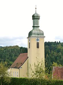
The parish church of St. Benedict was built in 1697 on the site of an older church using a late medieval tower with a baroque tower. It contains a carved statue of the Virgin Mary from 1500 and a statue of Sebastian from around 1720.
Economy and Infrastructure
Economy including agriculture and forestry
In 1998, according to official statistics, there were three in the field of agriculture and forestry, 351 in the manufacturing sector and 27 in the trade and transport sector at the place of work. In other economic areas, 68 people were employed at the place of work subject to social security contributions. There were 453 employees at the place of residence subject to social security contributions. There were none in the manufacturing sector and four in the construction sector. In addition, in 1999 there were 89 farms with an agriculturally used area of 1157 hectares, of which 573 hectares were arable land and 581 hectares were permanent green areas.
traffic
The most important road connection in the municipality is the federal road 20 , which runs west of the town of Rattiszell in a north-south direction . It leads to the federal motorway 3 (AS 106 Straubing ), which runs just under 10 km to the south . The district road SR 86 also runs in a north-south direction through the main town on the former route of the B 20. In the west, the state road St 2147 crosses the municipality.
education
In 2016 there were the following institutions:
- Primary schools: one with two teachers and 48 students
Individual evidence
- ↑ "Data 2" sheet, Statistical Report A1200C 202041 Population of the municipalities, districts and administrative districts 1st quarter 2020 (population based on the 2011 census) ( help ).
- ↑ a b Local elections in the district of Straubing-Bogen. District Sraubing-Bogen, accessed on May 30, 2020 .
- ^ Community Rattiszell in the local database of the Bavarian State Library Online . Bavarian State Library, accessed on July 14, 2017.
- ↑ District. Municipalities and districts. Bavarian Surveying Administration, archived from the original on April 11, 2013 ; accessed on March 31, 2015 .
- ↑ a b Wilhelm Volkert (Ed.): Handbook of the Bavarian offices, communities and courts 1799–1980 . CH Beck, Munich 1983, ISBN 3-406-09669-7 , p. 437 .
- ^ Federal Statistical Office (ed.): Historical municipality directory for the Federal Republic of Germany. Name, border and key number changes in municipalities, counties and administrative districts from May 27, 1970 to December 31, 1982 . W. Kohlhammer, Stuttgart / Mainz 1983, ISBN 3-17-003263-1 , p. 632 .
- ^ Rattiszell elementary school in the school database of the Bavarian State Ministry for Education and Culture , accessed on August 6, 2017
Web links
- Entry on the coat of arms of Rattiszell in the database of the House of Bavarian History


