Feldkirchen (Lower Bavaria)
| coat of arms | Germany map | |
|---|---|---|

|
Coordinates: 48 ° 50 ' N , 12 ° 32' E |
|
| Basic data | ||
| State : | Bavaria | |
| Administrative region : | Lower Bavaria | |
| County : | Straubing arch | |
| Height : | 348 m above sea level NHN | |
| Area : | 22.66 km 2 | |
| Residents: | 1989 (Dec. 31, 2019) | |
| Population density : | 88 inhabitants per km 2 | |
| Postal code : | 94351 | |
| Area code : | 09420 | |
| License plate : | SR , BOG, MAL | |
| Community key : | 09 2 78 121 | |
| Community structure: | 15 districts | |
| Address of the municipal administration: |
Main street 29 94351 Feldkirchen |
|
| Website : | ||
| Mayoress : | Barbara Unger (CSU) | |
| Location of the community Feldkirchen in the district of Straubing-Bogen | ||
Feldkirchen is a municipality in the Straubing-Bogen district in Lower Bavaria .
geography
The municipality is located in the Danube Forest region.
Community structure
There are 15 parish parts:
|
There are the districts of Feldkirchen and Mitterharthausen.
history
Until the church is planted
Feldkirchen belonged to the Landshut Rent Office and the Dingolfing Regional Court of the Electorate of Bavaria . In the course of the administrative reforms in Bavaria , today's municipality was created with the municipal edict of 1818 .
20th century
In preparation for the planned war the built Wehrmacht after 1936 the airbase Straubing-Mitterhart Hausen . For this purpose, the property of the Jewish cattle dealer and wholesaler Otto Selz was expropriated. Before 1933, Selz had successfully brought a trial against the anti-Semite Julius Streicher and his propaganda paper Der Stürmer . SA men kidnapped him in a forest in March 1933 and murdered him. Even after 1945 the case never came to court.
Numerous prisoners from the Flossenbürg and Dachau concentration camps, who were interned in several labor camps, were used to build the runways and to clear the rubble . At the end of the war, one of the death marches , during which many prisoners were killed or died of exhaustion, also touched Feldkirchen. A memorial stone at a crossroad where a sign points to the barracks commemorates nine victims of this forced labor .
In the years 1986 to 1997 a village renewal was carried out.
Incorporations
On May 1, 1978, the previously independent community of Mitterharthausen was incorporated. In 1982 Saulbach was reclassified from the Leiblfing community to the Feldkirchen community.
Population development
- 1961: 1,093 inhabitants
- 1970: 1,833 inhabitants
- 1987: 1,632 inhabitants
- 1991: 1,702 inhabitants
- 1995: 1,884 inhabitants
- 2000: 1,906 inhabitants
- 2005: 1,936 inhabitants
- 2010: 1,989 inhabitants
- 2015: 1,981 inhabitants
politics
Barbara Unger (CSU) is the honorary first mayor. She has been in office since May 1, 2008. In the mayoral election in 2020 it was confirmed with 70.8%.
coat of arms
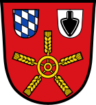
| Blazon : "In red a wheel with five golden ears of corn, above it on the right a label with the Bavarian diamonds, on the left a silver label with a black ploughshare inside." | |
Economy and Infrastructure
Economy including agriculture and forestry
The Gäuboden barracks of the Bundeswehr is economically important (users: medical training regiment , medical center Feldkirchen and the center for emergency training and exercises for the medical services of the Bundeswehr ) in Mitterharthausen.
According to official statistics, in 1998 there were eight in the field of agriculture and forestry, 53 in the manufacturing sector and 16 in the trade and transport sector at the place of work. In other economic sectors, 276 people were employed at the place of work subject to social security contributions. There were a total of 538 employees at the place of residence subject to social security contributions. There were none in the manufacturing sector and three in the construction sector. In addition, there were 59 agricultural holdings in 1999 with an agricultural area of 2010 ha, of which 1962 ha were arable land.
education
There are the following facilities:
- Kindergartens: 75 kindergarten places with 66 children (as of 1999)
- Elementary school Feldkirchen with five full-time teachers and 76 students (as of 2018/2019)
Architectural monuments
Web links
Individual evidence
- ↑ "Data 2" sheet, Statistical Report A1200C 202041 Population of the municipalities, districts and administrative districts 1st quarter 2020 (population based on the 2011 census) ( help ).
- ↑ a b Mayor / Lord Mayor in municipalities belonging to the district (as of May 1st, 2020). (xlsx) Bavarian State Office for Statistics, accessed on June 20, 2020 .
- ^ CSU Feldkirchen
- ↑ Feldkirchen community in the local database of the Bavarian State Library Online . Bavarian State Library
- ↑ District. Municipalities and districts. Bavarian Surveying Administration, archived from the original on April 11, 2013 ; accessed on March 31, 2015 .
- ↑ District in PDF. (PDF; 1.9 MB) Bavarian Surveying Administration, archived from the original on April 2, 2015 ; accessed on March 31, 2015 .
- ↑ Memorial sites for the victims of National Socialism. A documentation, Volume 1. Federal Agency for Civic Education, Bonn 1995, ISBN 3-89331-208-0 , p. 131
- ^ Federal Statistical Office (ed.): Historical municipality directory for the Federal Republic of Germany. Name, border and key number changes in municipalities, counties and administrative districts from May 27, 1970 to December 31, 1982 . W. Kohlhammer GmbH, Stuttgart / Mainz 1983, ISBN 3-17-003263-1 , p. 632 .
- ↑ Bavarian State Office for Statistics and Data Processing (Hrsg.): The municipalities of Bavaria according to the territorial status May 25, 1987. The population of the municipalities of Bavaria and the changes in the acquisitions and territory from 1840 to 1987 (= contributions to Statistics Bavaria . Issue 451). Munich 1991, p. 70 , urn : nbn: de: bvb: 12-bsb00070717-7 ( digitized version - footnotes 7 and 16).
- ↑ Entry on the coat of arms of Feldkirchen (Lower Bavaria) in the database of the House of Bavarian History
- ↑ Feldkirchen elementary school in the school database of the Bavarian State Ministry for Education and Culture , accessed on August 27, 2019.


