Geltolfing
|
Geltolfing
community Aiterhofen
Coordinates: 48 ° 50 ′ 18 ″ N , 12 ° 36 ′ 31 ″ E
|
|
|---|---|
| Height : | 339 m |
| Area : | 5.86 km² |
| Residents : | 339 (May 25 1987) |
| Population density : | 58 inhabitants / km² |
| Incorporation : | May 1, 1978 |
| Postal code : | 94330 |
| Area code : | 09421 |
|
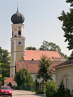
The parish church of St. Peter and Paul
|
|
Geltolfing is a district of the municipality of Aiterhofen in the Lower Bavarian district of Straubing-Bogen . The church village is located in the Gäuboden on the Aiterach about one kilometer southwest of Aiterhofen. In addition, only the desert Espermühle on the Aiterach 200 meters south of the village belonged to the former community .
history
The village was first documented in 1031 in the St. Emmeramer Rotulus . In 1126 Poppo von Geltolfing built a chapel, which was inaugurated by the Regensburg Bishop Chuno.
Geltolfing was Hofmark and had a palace complex. From 1534 to 1583 the Berlichingen (Perlaching) were owned by Geltolfing. In 1583 the Berlichingen brothers sold Castle Geltolfing together with the court brands Roßhaupten and Konzell to Hans Erberhard von Closen zu Arnstorf .
With the completion of the regional reform in Bavaria , the municipality of Geltolfing was incorporated into the municipality of Aiterhofen on May 1, 1978. The FC Geltolfing went on in 1976 in the FC Aiterhofen - Geltolfing. Other associations are the EHC “Sit in” Geltolfing, the Rifle Club Geltolfing and the Warrior, Soldier and Comradeship Association Geltolfing eV In 1985 the two previously independent parishes of Aiterhofen and Geltolfing were merged to form the Aiterhofen – Geltolfing pastoral care unit.
Population development
The population development of the former municipality of Geltolfing and its continuation is shown in the following table:
| 1840 | 1871 | 1900 | 1925 | 1939 | 1950 | 1961 | 1970 | 1975 | 1987 |
|---|---|---|---|---|---|---|---|---|---|
| 254 | 249 | 277 | 284 | 309 | 444 | 333 | 340 | 377 | 339 |

Buildings
In 1715 the foundation stone for the current church of St. Peter and Paul was laid on the banks of the Aitrach. The builder and probably also the plan designer was the Straubing city wall master Jakob Ruesch. The dome of the church tower is the work of the Straubing city carpenter Johann Attenberger. In 1718 the church was completed.
In the 19th century, the baroque furnishings were removed from the church and replaced by a neo-Gothic furnishings, which were replaced by modern furnishings in the 20th century. The Way of the Cross, created by Christian Wink in 1772, has been preserved .
The castle is a four-wing, two-story pond complex with a spacious inner courtyard. It was rebuilt between 1595 and 1598 and redesigned in Baroque style in 1776 and 1780. The entrance gate is on the west corner, and an arched bridge leads across the moat. The castle is not open to the public.
Web links
- Geltolfing in the location database of the Bavarian State Library Online . Bavarian State Library
Individual evidence
- ↑ a b Update based on the sum of the population of the places of the former municipality. Source of the individual values: Bavarian State Office for Statistics and Data Processing (publisher): Official city directory for Bavaria, territorial status: May 25, 1987 . Issue 450 of the articles on Bavaria's statistics. Munich November 1991, DNB 94240937X , p. 233 ( digitized version ).
- ^ Federal Statistical Office (ed.): Historical municipality directory for the Federal Republic of Germany. Name, border and key number changes in municipalities, counties and administrative districts from May 27, 1970 to December 31, 1982 . W. Kohlhammer GmbH, Stuttgart and Mainz 1983, ISBN 3-17-003263-1 , p. 632 .
- ^ Bavarian State Statistical Office: The municipalities of Bavaria. Changes in the inventory and area from 1840 to 1975. Issue 350 of the articles on Statistics Bavaria, page 62

