
Villenbach
| coat of arms | Germany map | |
|---|---|---|

|
Coordinates: 48 ° 31 ' N , 10 ° 37' E |
|
| Basic data | ||
| State : | Bavaria | |
| Administrative region : | Swabia | |
| County : | Dillingen on the Danube | |
| Management Community : | Wertingen | |
| Height : | 437 m above sea level NHN | |
| Area : | 17.81 km 2 | |
| Residents: | 1294 (Dec. 31, 2019) | |
| Population density : | 73 inhabitants per km 2 | |
| Postal code : | 86637 | |
| Area code : | 08296 | |
| License plate : | DLG, WHO | |
| Community key : | 09 7 73 179 | |
| Community structure: | 11 parts of the community | |
| Address of the municipal administration: |
Hauptstrasse 17 86637 Villenbach |
|
| Website : | ||
| Mayor : | Werner Filbrich ( Free Electoral Communities ) | |
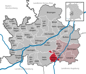
| Location of the community of Villenbach in the district of Dillingen on the Danube | ||
  |
||

Villenbach is a municipality in the Swabian district of Dillingen on the Danube and a member of the Wertingen administrative community .
geography
Villenbach is located in the Augsburg region. Villenbach and Hausen are located at the joint .
The municipality has 11 officially named municipal parts (the type of settlement is given in brackets ):
|
|
The districts of Riedsend, Villenbach and Wengen exist in the municipality .
history
Until the church is planted
Villenbach belonged to the cathedral monastery of Augsburg and was administered by the Obervogtamt Zusamaltheim . Since the secularization of 1802/03 the place belongs to Bavaria.
Incorporations
On May 1, 1978, the previously independent municipalities of Riedsend and Wengen and the district of Rischgau were incorporated into the dissolved municipality of Hegnenbach.
Population development
- 1961: 1126 inhabitants
- 1970: 1098 inhabitants
- 1987: 1062 inhabitants
- 1991: 1109 inhabitants
- 1995: 1145 inhabitants
- 2000: 1201 inhabitants
- 2005: 1265 inhabitants
- 2010: 1249 inhabitants
- 2015: 1269 inhabitants
Between 1988 and 2018, the community grew from 1,066 to 1,271 by 205 inhabitants or 19.2%.
politics
mayor
The 1st mayor has been Werner Filbrich (* 1959, Free Voting Association) since May 2014. In the election on March 15, 2020, he was confirmed in office with 91.5% for a further six years.
Municipal council
In the twelve-member municipal council, the Free Voting Association Villenbach-Rischgau-Hausen (FWG VRH) has 8 and the Free Voting Community Wengen-Riedsend (FWG WR) 4 seats (as of: local elections 2020 ).
Michael Stegmiller, Josef Dippel, 2nd Mayor Dieter Meißle, Franziska Eisenhofer, Patrick Hecken, Dr. med Achim Neumayr, Artur Bihler, Johannes Stegmiller (all Villenbach-Rischgau-Hausen) and 3rd Mayor Lydia Edin, Armin Langenmair, Uta Hill, Robert Jungblut (all Wengen-Riedsend)
tax income
The municipal tax revenue in 2018 was € 240,000.
coat of arms
The description of the coat of arms reads: A silver ox head looking in red.
Attractions
Economy and Infrastructure
Economy including agriculture and forestry
In 2013 there were a total of 65 employees subject to social security contributions at the place of work. There were a total of 509 employees at the place of residence subject to social security contributions (commuter balance: 444). In 2010 there were a total of 26 farms. The agriculturally used area was 1055 hectares, of which 814 hectares were arable land.
education
There are the following institutions (as of 2020):
- Day care facility: 40 kindergarten places and 12 day nursery places with 50 children
Web links
- Homepage for Villenbach
- Entry for the coat of arms of Villenbach in the database of the House of Bavarian History
Individual evidence
- ↑ "Data 2" sheet, Statistical Report A1200C 202041 Population of the municipalities, districts and administrative districts 1st quarter 2020 (population based on the 2011 census) ( help ).
- ^ Community of Villenbach in the local database of the Bavarian State Library Online . Bayerische Staatsbibliothek, accessed on August 30, 2019.
- ↑ a b c Federal Statistical Office (ed.): Historical municipality directory for the Federal Republic of Germany. Name, border and key number changes in municipalities, counties and administrative districts from May 27, 1970 to December 31, 1982 . W. Kohlhammer, Stuttgart / Mainz 1983, ISBN 3-17-003263-1 , p. 768 and 770 .

Aislingen | Bachhagel | Bächingen an der Brenz | Binswangen | Bissingen | Blind home | Buttenwiesen | Dillingen on the Danube | Finningen | Glött | Gundelfingen an der Donau | Haunsheim | Höchstädt on the Danube | Holzheim | Laugna | Lauingen | Lutzingen | Medlingen | Mödingen | Schwenningen | Syrgenstein | Villenbach | Wertingen | Wittislingen | Ziertheim | Zöschingen | Zusamaltheim