
Administrative community Wertingen
| coat of arms | Germany map | |
|---|---|---|
 Help on coat of arms |
Coordinates: 48 ° 33 ' N , 10 ° 41' E |
|
| Basic data | ||
| State : | Bavaria | |
| Administrative region : | Swabia | |
| County : | Dillingen on the Danube | |
| Area : | 127.12 km 2 | |
| Residents: | 14,778 (Dec. 31, 2019) | |
| Population density : | 116 inhabitants per km 2 | |
| License plate : | DLG, WHO | |
| Association key : | 09 7 73 5718 | |
| Association structure: | 5 municipalities | |
| Association administration address : |
Schulstr. 12 86637 Wertingen, Germany |
|
| Website : | ||
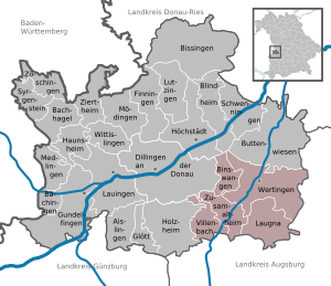
| Location of the Wertingen administrative community in the Dillingen district on the Danube | ||
  |
||

The Wertingen administrative community is located in the Swabian district of Dillingen on the Danube and is formed by the following communities:
- Binswangen , 1325 inhabitants, 11.91 km²
- Laugna , 1601 inhabitants, 27.61 km²
- Villenbach , 1294 inhabitants, 17.81 km²
- Wertingen , city , population 9346, 51.87 km²
- Zusamaltheim , 1212 inhabitants, 17.92 km²
The administrative association is based in Wertingen.
Individual evidence
- ↑ "Data 2" sheet, Statistical Report A1200C 202041 Population of the municipalities, districts and administrative districts 1st quarter 2020 (population based on the 2011 census) ( help ).
Administrative communities in the district of Dillingen adDonau