
Wittislingen administrative community
| coat of arms | Germany map | |
|---|---|---|
 Help on coat of arms |
Coordinates: 48 ° 37 ' N , 10 ° 25' E |
|
| Basic data | ||
| State : | Bavaria | |
| Administrative region : | Swabia | |
| County : | Dillingen on the Danube | |
| Area : | 61.26 km 2 | |
| Residents: | 4760 (Dec. 31, 2019) | |
| Population density : | 78 inhabitants per km 2 | |
| License plate : | DLG, WHO | |
| Association key : | 09 7 73 5715 | |
| Association structure: | 3 municipalities | |
| Association administration address : |
Marienplatz 6 89426 Wittislingen |
|
| Website : | ||
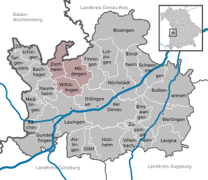
| Location of the administrative community Wittislingen in the district of Dillingen on the Danube | ||
  |
||

The Wittislingen administrative community is located in the Swabian district of Dillingen on the Danube and is formed by the following communities:
- Mödingen , population 1354, 23.02 km²
- Wittislingen , market , 2387 inhabitants, 17.42 km²
- Ziertheim , 1019 inhabitants, 20.82 km²
The administrative community is based in Wittislingen.
Individual evidence
- ↑ "Data 2" sheet, Statistical Report A1200C 202041 Population of the municipalities, districts and administrative districts 1st quarter 2020 (population based on the 2011 census) ( help ).
Administrative communities in the district of Dillingen adDonau