Wittislingen
| coat of arms | Germany map | |
|---|---|---|

|
Coordinates: 48 ° 37 ' N , 10 ° 25' E |
|
| Basic data | ||
| State : | Bavaria | |
| Administrative region : | Swabia | |
| County : | Dillingen on the Danube | |
| Management Community : | Wittislingen | |
| Height : | 450 m above sea level NHN | |
| Area : | 17.42 km 2 | |
| Residents: | 2387 (Dec. 31, 2019) | |
| Population density : | 137 inhabitants per km 2 | |
| Postal code : | 89426 | |
| Area code : | 09076 | |
| License plate : | DLG, WHO | |
| Community key : | 09 7 73 183 | |
| LOCODE : | DE TIS | |
| Market structure: | 4 parts of the community | |
Market administration address : |
Marienplatz 6 89426 Wittislingen |
|
| Website : | ||
| Mayor : | Thomas Reicherzer ( SPD ) | |
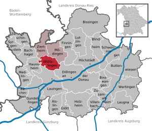
| Location of the Wittislingen market in the Dillingen district on the Danube | ||
Wittislingen is a market in the Swabian district of Dillingen on the Danube and the seat of the Wittislingen administrative community .
geography
The market is in the Egautal .
The municipality has four officially named municipal parts (the type of settlement is given in brackets ):
- Beutenstetterhof ( wasteland )
- Schabringen ( parish village )
- Wittislingen (main town)
- Zöschlingsweiler ( village )
history
Archaeological finds
Wittislingen is located on the southern edge of the Swabian Alb on both sides of the Egau , which, coming from a trough-like valley from the north, cuts through a narrow valley before it emerges onto the high terrace level of the Jura. Up to five meters thick, layers of freshwater limestone (lime, tuff, dauch, sand) are attached to the Jura valley. The place and the district are ancient, rich settlement soil. The archaeological finds range from the Middle Paleolithic through all prehistoric and early cultural stages to the High Middle Ages. There is a Silex raw material deposit near Wittislingen . Graves from the time of the Merovingians show that the area was settled early on.
Wittislingen is internationally known for its archaeological finds, on the one hand by the "Wittislinger Fund of 1881", on the other hand in the most recent time from 1951 by the profiles of the freshwater or spring limestone ( tufa ), from which both the previously unclear age of the Neolithic ( was assumed to be 2500 BC) based on the radiocarbon method (C14) to around 4100 BC. BC could be determined. Wittislingen is an Alemannic foundation. Among the finds stands out the grave of an Alemannic high nobility from the 7th century, whose magnificent gifts are now kept as a Wittislinger find in the prehistoric state collection in Munich.
middle Ages
The grave of Saint Ulrich (890–973, Bishop of Augsburg), which is in the St. Ulrich and Afra basilica , suggests that Wittislingen was the seat of a noble family at the latest at this time, from which Saint Ulrich was descended. Significant for this assumption is the biography of Saint Ulrich in Gerhard's Vita, that shortly before his death in 973, Bishop Ulrich spent a few days in the oppidum “quod nominatur Uuittegislingua” with his two nephews, Counts Richwin and Hubald, in order to build an extension to order the local church. The graves of his parents Hubald and Burga, which were located near this church, were no longer to be exposed to the weather, but were to be integrated into the interior of the church.
The sovereignty over Wittislingen had been with the Duchy of Bavaria since 1261 and with Pfalz-Neuburg from 1505 , the lower jurisdiction with its own lower court with the Hochstift Augsburg . Especially in the period between 1455 and 1560, the place grew through subdivisions.
Modern times and the present
It was not until 1783 that the Augsburg bishopric also acquired the high jurisdiction through an exchange . At that time Wittislingen was also the seat of a bailiff of the Augsburg bishopric. Since the Reichsdeputationshauptschluss of 1803 the place belongs to the Kingdom of Bavaria . In 1818, Wittislingen became an independent political municipality as part of the administrative reforms in the Kingdom of Bavaria.
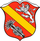
The town has had the coat of arms shown here since 1952. It points to the important early days as well as the great past of the place, ancestral seat and property of the Counts of Dillingen and property of the bishopric of Augsburg. 1955 Wittislingen was raised to the market .
Incorporations
On May 1, 1978, the previously independent community of Schabringen was incorporated.
Population development
Between 1988 and 2018 the market grew from 2,321 to 2,415 by 94 inhabitants or 4.1%.
politics
City council and mayor
The municipal council has 14 members. Since the local elections on March 16, 2014 , the seats have been divided into the following lists:
- CSU : 6 seats
- Free Independent Electoral Association (FUW): 4 seats
- SPD / Independent Citizens: 2 seats
- Free voters : 2 seats
In the local elections on March 15, 2020, Thomas Reicherzer (SPD) was elected the new mayor with 50.5% of the votes; the CSU applicant lost 49.5%. Ulrich Müller (non-partisan) has been the first mayor since October 1, 2012, and Paul Seitz (CSU) has been the second mayor since 2014.
coat of arms
The description of the coat of arms reads: In red a golden sloping bar, accompanied above by a striding silver lion, below by the large iron gable of Whiting.
Architectural monuments
- Parish church of St. Ulrich and Martin . It stands on the site of an old Romanesque-style church that was demolished in 1750. The St. Martin's patronage was replaced in 1805 by an St. Ulrich's patronage.
Personalities
- Joseph von Weber (1753-1831); Catholic clergyman and scientist , worked here as local pastor from 1811 to 1821.
societies
- Wittislingen Music Association
- TSV Wittislingen
- Beekeeping Association Wittislingen
- Stork friends Wittislingen
- Schabringen cultural event association
Web links
- Entry on the coat of arms of Wittislingen in the database of the House of Bavarian History
Individual evidence
- ↑ "Data 2" sheet, Statistical Report A1200C 202041 Population of the municipalities, districts and administrative districts 1st quarter 2020 (population based on the 2011 census) ( help ).
- ^ Community Wittislingen in the local database of the Bayerische Landesbibliothek Online . Bayerische Staatsbibliothek, accessed on August 30, 2019 .. There five officially named parts of the municipality, since Zöschlingsweiler is incorrectly listed twice.
- ^ Federal Statistical Office (ed.): Historical municipality directory for the Federal Republic of Germany. Name, border and key number changes in municipalities, counties and administrative districts from May 27, 1970 to December 31, 1982 . W. Kohlhammer, Stuttgart / Mainz 1983, ISBN 3-17-003263-1 , p. 770 .


