
Schwenningen (Danube)
| coat of arms | Germany map | |
|---|---|---|

|
Coordinates: 48 ° 39 ' N , 10 ° 39' E |
|
| Basic data | ||
| State : | Bavaria | |
| Administrative region : | Swabia | |
| County : | Dillingen on the Danube | |
| Management Community : | Höchstädt on the Danube | |
| Height : | 416 m above sea level NHN | |
| Area : | 25.05 km 2 | |
| Residents: | 1419 (Dec. 31, 2019) | |
| Population density : | 57 inhabitants per km 2 | |
| Postal code : | 89443 | |
| Area code : | 09070 | |
| License plate : | DLG, WHO | |
| Community key : | 09 7 73 164 | |
| Community structure: | 10 parish parts | |
| Address of the municipal administration: |
Schulstr. 3a 89443 Schwenningen, Germany |
|
| Website : | ||
| Mayor : | Johannes Ebermayer ( Young Citizens' Block ) | |
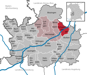
| Location of the community Schwenningen in the district of Dillingen on the Danube | ||
  |
||


Schwenningen is a municipality in the Swabian district of Dillingen an der Donau and a member of the administrative community Höchstädt an der Donau .
geography
Schwenningen is located in the Augsburg region in the Donauried. The community of Schwenningen should not be confused with the Schwenningen district of the district town of Villingen-Schwenningen .
The municipality has 10 officially named parts of the municipality (the type of settlement is given in brackets ):
|
|
There are the districts of Gremheim and Schwenningen.
history
Until the church is planted
Until the 13th century, the Counts of Dillingen were landlords and court lords. Schwenningen later belonged to the von Jubert family. The place was part of the Electorate of Bavaria and formed a closed Hofmark , whose seat was Schwenningen. In 1818 the community edict created today's political community.
Incorporations
On May 1, 1978, the previously independent community of Gremheim was incorporated.
Population development
- 1961: 1450 inhabitants
- 1970: 1397 inhabitants
- 1987: 1343 inhabitants
- 1991: 1428 inhabitants
- 1995: 1461 inhabitants
- 2000: 1465 inhabitants
- 2005: 1475 inhabitants
- 2010: 1405 inhabitants
- 2015: 1448 inhabitants
Between 1988 and 2018 the municipality grew from 1,337 to 1,406 by 69 inhabitants or 5.2%.
politics
Municipal council
The municipal council has twelve members. Since the 2014 local elections, the seats have been divided into the following lists:
- Non-party lists: 9 seats (74.2%)
- CSU: 3 seats (25.8%)
mayor
Mayor has been Johannes Ebermayer (Bürgerblock - Junge Bürger Schwenningen) since May 2020; he was elected from among three applicants in the first ballot on March 15, 2020 with 59.1% of the vote. His predecessor was Reinhold Schilling (Bürgerblock - Junge Bürger / CSU) from May 1996 to April 2020.
tax income
In 2013, the municipal tax revenue was € 958,000, of which the trade tax revenue (net) was € 156,000.
coat of arms
The description of the coat of arms reads: diagonally divided by a golden bar; above in blue a striding, gold-armored silver lion, below in red a silver deer pole.
Culture and sights
Attractions
- Catholic parish church of St. Ulrich and Johann Baptist
- Kalteneck Castle
Architectural monuments
Economy and Infrastructure
Economy including agriculture and forestry
According to official statistics, there were 98 employees subject to social insurance at the place of work in 2013. Residential workers were paid 608, bringing the commuter balance to 510 employees.
In 2010 there were 45 farms. The agriculturally used area was 2188 ha, of which 1880 ha were arable land and 308 ha were permanent green space.
traffic
Schwenningen (Danube) has the Schwenningen (Bay) stop , which was newly built in 2006 and provides hourly connections to Ulm as well as Donauwörth , Ingolstadt and Regensburg via the Ingolstadt – Neuoffingen railway line . Schwenningen has a connection to federal highway 16 .
education
There are the following institutions (status: 2014):
- Kindergarten: 50 kindergarten places with 30 children, 3 of them under 3 years of age
- Primary school: with 5 classes and 99 students
Web links
- Entry on the coat of arms of Schwenningen (Danube) in the database of the House of Bavarian History
Individual evidence
- ↑ "Data 2" sheet, Statistical Report A1200C 202041 Population of the municipalities, districts and administrative districts 1st quarter 2020 (population based on the 2011 census) ( help ).
- ^ Community Schwenningen in the local database of the Bavarian State Library Online . Bayerische Staatsbibliothek, accessed on August 30, 2019.
- ↑ a b c Federal Statistical Office (ed.): Historical municipality directory for the Federal Republic of Germany. Name, border and key number changes in municipalities, counties and administrative districts from May 27, 1970 to December 31, 1982 . W. Kohlhammer, Stuttgart / Mainz 1983, ISBN 3-17-003263-1 , p. 770 .

Aislingen | Bachhagel | Bächingen an der Brenz | Binswangen | Bissingen | Blind home | Buttenwiesen | Dillingen on the Danube | Finningen | Glött | Gundelfingen an der Donau | Haunsheim | Höchstädt on the Danube | Holzheim | Laugna | Lauingen | Lutzingen | Medlingen | Mödingen | Schwenningen | Syrgenstein | Villenbach | Wertingen | Wittislingen | Ziertheim | Zöschingen | Zusamaltheim