
Laugna
| coat of arms | Germany map | |
|---|---|---|

|
Coordinates: 48 ° 32 ' N , 10 ° 42' E |
|
| Basic data | ||
| State : | Bavaria | |
| Administrative region : | Swabia | |
| County : | Dillingen on the Danube | |
| Management Community : | Wertingen | |
| Height : | 442 m above sea level NHN | |
| Area : | 27.61 km 2 | |
| Residents: | 1601 (Dec. 31, 2019) | |
| Population density : | 58 inhabitants per km 2 | |
| Postal code : | 86502 | |
| Area code : | 08272 | |
| License plate : | DLG, WHO | |
| Community key : | 09 7 73 143 | |
| Community structure: | 7 parts of the community | |
| Association administration address: | Schulstr. 12 86637 Wertingen, Germany |
|
| Website : | ||
| Mayor : | Johann Gebele (FWO) | |
| Location of the municipality of Laugna in the district of Dillingen on the Danube | ||
  |
||

Laugna is a municipality in the Swabian district of Dillingen on the Danube and a member of the Wertingen administrative community .
geography
The community is located between Dillingen (15 km) and Augsburg (22 km), about 3.5 km southeast of Wertingen and is part of the Augsburg planning region . The Holzwinkel , part of the Augsburg - Western Forests nature park, begins south of the municipality . The Laugna runs in the east of the municipality and takes in the Asbacher Bach .
The municipality has seven officially named municipality parts (the type of settlement and the number of inhabitants as of May 2019 are given in brackets ):
- Asbach ( Dorf , 188 E.)
- Bocksberg ( Kirchdorf , 304 E.)
- Hinterbuch (Dorf, 56 E.)
- Kaag ( hamlet , 15 E.)
- Laugna ( parish village , 648 E.)
- Modelshausen (Pfarrdorf, 46 E.)
- Easter book (Pfarrdorf, 249 E.)
history
The earliest known settlement is from a Celtic conquest around 100 BC. Started out. The pre-German name "Longenaha" or colloquially "Longna" suggests this. Around 15 BC The Romans occupied the area. Around 410 AD they were expelled by the Alemannic tribe of the Suebi ; Laugna became a Germanic Urmark .
Laugna was owned by the Fugger Family Foundation , which had acquired the Bocksberg rule in 1613 . With the Rhine Confederation Act 1806, the place came to the Kingdom of Bavaria . In the course of the administrative reforms in Bavaria, the municipality was created with the municipal edict of 1818 .
Incorporations
All parts of the municipality of today's municipality belonged to the Wertingen district, which was dissolved in 1972 . On May 1, 1978, as part of the municipal reform, the municipalities of Bocksberg with its districts Hinterbuch, Kaag and Modelshausen and Osterbuch with its municipality of Asbach were incorporated.
The last mayor of the old municipality of Laugna was Johann Öttle, who was also re-elected as mayor of the new municipality.
Population development
Between 1988 and 2018 the municipality grew from 1,330 to 1,577 by 247 inhabitants or by 18.6%.
Today's municipality:
| year | 1961 | 1970 | 1987 | 1991 | 1995 | 2000 | 2005 | 2010 | 2015 |
|---|---|---|---|---|---|---|---|---|---|
| Residents | 1314 | 1304 | 1313 | 1422 | 1479 | 1533 | 1553 | 1543 | 1577 |
| source |
Place Laugna:
| year | 1871 | 1950 | 1987 | 2019 |
|---|---|---|---|---|
| Residents | 508 | 766 | 654 | 648 |
| source |
politics
mayor
The first mayor is Johann Gebele (Free Voters Group Osterbuch), the second mayor is Helmut Bartsch (Non-Party Voters Group Laugna). Johann Gebele was elected mayor for the first time in March 2014 in the first ballot and was confirmed in office on March 15, 2020 with 96.6% of the votes without any competitors.
Former mayor
- 1978–1980: Johann Öttle from Laugna (previously mayor of the old municipality of Laugna)
- 1980–1996: Günter Meitinger from Bocksberg
- 1996–2014: Georg Keis sen. from Asbach
- Since 2014: Johann Gebele from Osterbuch
Municipal council
The municipal council has twelve members:
- Non-party voter group Laugna (PWL): 5 seats (2008: 5 seats)
- Free Voting Group Osterbuch (FWO) 4 seats (2008: 3 seats)
- Free voter community Bocksberg (FWB): 3 seats (2008: 4 seats)
coat of arms
The description of the coat of arms reads: Above a golden shield base, in it three green bars placed at an angle to the left and cut at an angle, split by blue and gold; in front a golden lily cross, behind a striding black goat on a single green four-mountain.
Architectural monuments
- Fugger Castle in Laugna
- Catholic parish church St. Elisabeth in Laugna
- Catholic branch church of the Holy Trinity and St. Leonhard in Bocksberg
- Catholic parish church St. Peter in Modelshausen
- Catholic parish church St. Michael in Osterbuch
- Catholic Ottilien Chapel in Asbach
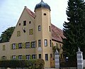
Laugna Fugger Castle

St. Elisabeth in Laugna

Holy Trinity and St. Leonhard in Bocksberg

Church of St. Michael in Osterbuch


Economy and Infrastructure
Economy including agriculture and forestry
In 1998, according to official statistics, there were 20 employees in the field of agriculture and forestry, 70 in the manufacturing industry and four in the field of trade and transport at the place of work. In other economic areas, 26 people were employed at the place of work subject to social security contributions. There were 557 employees at the place of residence subject to social insurance contributions. There were four in manufacturing and three in construction. In addition, in 1999 there were 49 farms with an agricultural area of 1377 ha, 988 ha of which were arable land.
The municipal tax revenue amounted to the equivalent of € 540,000 in 1999, of which € 40,000 was trade tax revenue (net).
traffic
The state road 2036 crosses the municipality and the village of Laugna from north to south . From there, the DLG 33 district road runs east.
education
In 1999 the following institutions existed:
- Kindergarten: 50 kindergarten places with 61 children
All schools for the community are located in Wertingen.
Others
The sports club for the entire community is FC Osterbuch, founded in 1967.
The community owns a schnapps distillery that was founded in 1923 and produces the so-called Laugna water. The schnapps is made mainly from apples, pears and plums, the fruit comes exclusively from the area.
Personalities
- Bartholomäus Holzhauser (1613–1658), son of a shoemaker from Laugna, Catholic priest and founder of the order
Web links
- Community website
- Entry on the coat of arms of Laugna in the database of the House of Bavarian History
Individual evidence
- ↑ "Data 2" sheet, Statistical Report A1200C 202041 Population of the municipalities, districts and administrative districts 1st quarter 2020 (population based on the 2011 census) ( help ).
- ^ Community Laugna in the local database of the Bavarian State Library Online . Bayerische Staatsbibliothek, accessed on August 31, 2019.
- ↑ a b Congregation Website: Our Congregation - Numbers and Dates
- ^ Community website: Laugna town - history
- ↑ a b c Federal Statistical Office (ed.): Historical municipality directory for the Federal Republic of Germany. Name, border and key number changes in municipalities, counties and administrative districts from May 27, 1970 to December 31, 1982 . W. Kohlhammer, Stuttgart / Mainz 1983, ISBN 3-17-003263-1 , p. 770 .
- ↑ Kgl. Statistical Bureau (ed.): Complete list of localities of the Kingdom of Bavaria. According to districts, administrative districts, court districts and municipalities, including parish, school and post office affiliation ... with an alphabetical general register containing the population according to the results of the census of December 1, 1875 . Adolf Ackermann, Munich 1877, 2nd section (population figures from 1871, cattle figures from 1873), Sp. 1527 , urn : nbn: de: bvb: 12-bsb00052489-4 ( digitized version ).
- ↑ Bavarian State Statistical Office (ed.): Official place directory for Bavaria - edited on the basis of the census of September 13, 1950 . Issue 169 of the articles on Bavaria's statistics. Munich 1952, DNB 453660975 , Section II, Sp. 1397 ( digitized version ).
- ↑ Bavarian State Office for Statistics and Data Processing (Ed.): Official local directory for Bavaria, territorial status: May 25, 1987 . Issue 450 of the articles on Bavaria's statistics. Munich November 1991, DNB 94240937X , p. 395 ( digitized version ).
- ↑ Results of the 2014 local elections from the Bavarian State Office for Statistics
Asbach | Bocksberg | Back book | Kaag | Laugna | Modelshausen | Easter book

Aislingen | Bachhagel | Bächingen an der Brenz | Binswangen | Bissingen | Blind home | Buttenwiesen | Dillingen on the Danube | Finningen | Glött | Gundelfingen an der Donau | Haunsheim | Höchstädt on the Danube | Holzheim | Laugna | Lauingen | Lutzingen | Medlingen | Mödingen | Schwenningen | Syrgenstein | Villenbach | Wertingen | Wittislingen | Ziertheim | Zöschingen | Zusamaltheim