
Mertingen
| coat of arms | Germany map | |
|---|---|---|

|
Coordinates: 48 ° 39 ' N , 10 ° 48' E |
|
| Basic data | ||
| State : | Bavaria | |
| Administrative region : | Swabia | |
| County : | Danube Ries | |
| Height : | 411 m above sea level NHN | |
| Area : | 38.42 km 2 | |
| Residents: | 4045 (Dec. 31, 2019) | |
| Population density : | 105 inhabitants per km 2 | |
| Postal code : | 86690 | |
| Area code : | 09078 | |
| License plate : | DON, Lower Austria | |
| Community key : | 09 7 79 181 | |
| Community structure: | 7 parts of the community | |
| Address of the municipal administration: |
Fuggerstrasse 5 86690 Mertingen |
|
| Website : | ||
| Mayor : | Veit Meggle ( PWG / FW ) | |
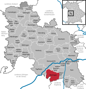
| Location of the municipality of Mertingen in the Donau-Ries district | ||
  |
||

Mertingen is a municipality in the Bavarian Swabia , district of Donau-Ries . It is located near the city of Donauwörth and about 35 km north of Augsburg .
geography
location
Mertingen lies on the Schmutter just before it flows into the Danube .
Community structure
The municipality consists of two districts and has seven officially named municipality parts :
- Main town, district and parish village of Mertingen (3234 inhabitants) with the parish village of Heißesheim (185 inhabitants), Mertingen train station, the hamlet of Überfeldsiedlung, the Burghöfe estate and the wasteland of Hagenmühle
- District and church village Druisheim (453 inhabitants)
Planning region
Mertingen is part of the Augsburg planning region .
history

Until the 19th century
The earliest traces of human settlement date from the Paleolithic Age . This is proven by the rare single find of a hand ax on the ridge southeast of Mertingen. In the year 15 BC At the time of Emperor Augustus , the Romans conquered the Alpine region and advanced as far as the Danube. They occupied this newly acquired area, which was initially called Vindelicien and was later organized as the Roman province of Raetia with the capital and legion camp Augsburg (Augusta Vindelicorum). The Romans secured both the Danube border in the Mertingen area and the strategically important fork in the road at the castle courtyards in the period from 41 to 54 and 259/260 by building two forts one after the other . The Roman highway Via Claudia Augusta, built around 44 AD, coming from Italy via Augsburg, ended here at the Submuntorium fort . Not far from the castle courtyards (then Latin: Submuntorium ) it flowed into the Roman military road that accompanied the Danube near the south bank, which historians called Donausüdstrasse . The Danube formed in the section of Mertingen between 15 BC. Until about 95 AD the northern border of the Roman Empire to the previously unoccupied Germania . After that, the border across the Danube was moved to the north (see Raetischer Limes ). Around the year 260 AD, the imperial border in this area was at least de facto withdrawn and fortified to the south bank of the Danube as a result of pressure from the Germanic tribes ( Limesfall ) ( Danube-Iller-Rhein-Limes ). The Romans were the 5th century center of the invading from the north from Germania Alemanni ousted. In 1969, 32 row graves from the Merovingian era were discovered in the “Wörthfeld” corridor, along with rich grave goods (weapons and jewelry). This and other findings can be assumed that the villages that today the church Mertingen form after the withdrawal of Celtic-Roman population during the conquest by the Alemanni were after many years of oblivion Verlassen- and re-established.
Halfway between Mertingen and Druisheim one was from the 7th century to today's Good Burghöfe manor with farmyard (the later Burghöfe) which fixes the 9th century and the castle Turenberc was expanded, congestion fisches TafelGUT was, but in the 15th Century was abandoned again.
The place "Mardinga" is mentioned for the first time in 969 in a deed of foundation of Bishop Ulrich . In 1634, during the Thirty Years' War, heavy devastation was wrought by 15,000-strong Swedish troops under King Gustav II Adolf .
In 1796 and 1800, French troops invaded Mertingen. When Napoleon crossed the Danube in 1805, 200,000 men marched through Mertingen for three days. During his Russian campaign in 1812, 30,000 Bavarian soldiers - including six Mertingers - died .
In 1870, many Mennonites from Baden settled in Heißesheim .
Incorporations
The district of Druisheim was incorporated on May 1, 1978 as part of the regional reform .
Population development
Between 1988 and 2018 the community grew from 2,841 to 4,020 by 1,179 inhabitants or 41.5% - the highest percentage increase in the district in the period mentioned.
The population development of Mertingen (including the districts) in numbers.
| year | 1961 | 1970 | 1975 | 1980 | 1985 | 1990 | 1995 | 2000 | 2005 | 2010 | 2015 |
|---|---|---|---|---|---|---|---|---|---|---|---|
| Residents | 2515 | 2652 | 2350 | 2806 | 2861 | 2903 | 3322 | 3675 | 3866 | 3808 | 3979 |
politics
mayor
Veit Meggle (nominated by PWG / FW and Free Citizens / SPD) has been the first mayor since May 1, 2020.
Mertingen has had a full-time mayor since July 1, 1972. Meggle's predecessors were:
- Hans Leinauer (CSU) from July 1, 1972 to April 30, 1996
- Albert Lohner (CSU) from May 1, 1996 to April 30, 2020.
Municipal council
The distribution of seats in the municipal council for the 2020–2026 term of office is as follows:
The distribution of seats in the municipal council for the 2014–2020 term of office is as follows:
- CSU: 7
- SPD : 4
- PWG: 5
In the 2008–2014 term of office , the SPD had one more seat and the PWG one less seat.
1. Mayor Albert Lohner is also a member of the municipal council; he has been in office since May 1, 1996 and was re-elected in 2002, 2008 and 2014.
coat of arms
Description: Split over a shield base split by silver and red; in front a silver cross with two cross arms in red, behind in three rows of iron hats made of blue and silver.
Meaning: The colors silver and red in the base of the shield indicate the bishopric of Augsburg, which owned Mertingen as early as the 11th century. The silver cross represents the cross particle of the monastery Heilig Kreuz von Donauwörth and stands as a speaking symbol for its rule in the municipality. The iron hats are reminiscent of the marshals of Pappenheim, who were feudal lords in Mertingen around 1280 and who had these symbols in their coat of arms.
Community partnerships
Culture and sights
music
Thanks to the concerts of the Kulturkreis , Mertingen has become known far beyond the region as a platform for young, highly talented musicians at the beginning of their careers. An event with the violinist Veronika Eberle or a reading with Peter Härtling , accompanied by the pianist Hartmut Höll and the bassist Peter Lika , who was born in Mertingen, and a recital with Francisco Araiza (tenor) are successes of this committed work.
museum
The Museumfreunde Mertingen have worked over many years to restore, expand and set up three old, typical buildings - a rural property, a barn and an old schoolhouse. They keep important testimonies of the past and give a clear picture of the way of life in a north Swabian village in the 19th and early 20th centuries.
Architectural monuments
Economy and Infrastructure
traffic
Road traffic
The four-lane federal highway 2 runs on the outskirts of Mertingen , which leads north via Donauwörth to Nuremberg and south to Augsburg to the federal motorway 8 Stuttgart - Munich .
Local public transport (ÖPNV)
Mertingen station is on the Augsburg – Nördlingen railway line . Local trains run by Deutsche Bahn in the Augsburg Transport Association (AVV) run every 30 minutes between Donauwörth and Augsburg and stop in Mertingen. This means that there are very good connections to Munich and Nuremberg.
Until 1997 Mertingen was the starting point of the Mertingen – Wertingen railway line . Passenger traffic was stopped in 1981. On July 9, 2020, the line was named as a test case of a railway line to be reactivated in the position paper of the VDV . It is number 5311.


Bike paths
Mertingen is on the long-distance cycle path , which runs as the Via Claudia Augusta along an ancient Roman road of the same name .
economy
For the approximately 3800 inhabitants there are 2550 jobs directly on site.
The following well-known companies are based in Mertingen:
- Zott (dairy products)
- Sigel (office products)
- Fendt Caravan (caravans and mobile homes)
- Karger - Mertingen galvanizing plant (deepest horizontal boiler in Europe)
education
- Elementary school Mertingen (188 students in the school year 2010/2011)
- Mertingen day care center with 197 places in crèche , kindergarten and day-care center (as of 2011, occupied by 198 children)
freetime and sports
- The FC Mertingen was founded in 1929 and has, among other departments for football , table tennis , gymnastics and archery .
Personalities
- Anton von Steichele (1816–1889), Archbishop of Munich and Freising, born in Mertingen
- Leonhard Kleiber (1863–1942), military bandmaster and composer, born in Mertingen
Web links
- Entry on the coat of arms of Mertingen in the database of the House of Bavarian History
Individual evidence
- ↑ "Data 2" sheet, Statistical Report A1200C 202041 Population of the municipalities, districts and administrative districts 1st quarter 2020 (population based on the 2011 census) ( help ).
- ^ Mertingen community in the local database of the Bavarian State Library Online . Bayerische Staatsbibliothek, accessed on September 2, 2019.
- ^ Federal Statistical Office (ed.): Historical municipality directory for the Federal Republic of Germany. Name, border and key number changes in municipalities, counties and administrative districts from May 27, 1970 to December 31, 1982 . W. Kohlhammer, Stuttgart / Mainz 1983, ISBN 3-17-003263-1 , p. 794 .
- ^ VDV: reactivation of railway lines. Retrieved August 5, 2020 .
Druisheim | Mertingen with Burghöfe, Hagenmühle, Heißesheim , Mertingen train station and Überfeldsiedlung

Alerheim | Amerdingen | Asbach-Bäumenheim | Auhausen | Buchdorf | Daiting | Deiningen | Donauwörth | Ederheim | Ehingen am Ries | Forheim | Fremdingen | Fünfstetten | Genderkingen | Hainsfarth | Harburg (Swabia) | Hohenaltheim | Holzheim | Huisheim | Kaisheim | Maihingen | Marktoffingen | Marxheim | Megesheim | Mertingen | Mönchsdeggingen | Monheim | Möttingen | Munningen | Munster | Niederschönenfeld | Nordlingen | Oberndorf am Lech | Oettingen in Bavaria | Otting | Rain | Reimlingen | Rögling | Tagmersheim | Tapfheim | Wallerstein | Wechingen | Wemding | Wolferstadt
Unregulated areas: Dornstadt-Linkersbaindt | Ester wood