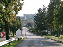
Druisheim
|
Druisheim
community Mertingen
|
|
|---|---|
| Coordinates: 48 ° 38 ′ 1 ″ N , 10 ° 48 ′ 55 ″ E | |
| Height : | 425 m |
| Residents : | 501 (2016) |
| Incorporation : | May 1, 1978 |
| Postal code : | 86690 |
| Area code : | 09078 |
Druisheim is a district of the municipality of Mertingen in the Donau-Ries district in the Bavarian administrative district of Swabia .
geography
The church village is located at the southern end of the Donau-Ries district at an altitude of 432 m above sea level. NN and has 501 inhabitants (as of 2016). On the outskirts, the Schmutter flows through the place just before it joins the Danube .
history
The Germanic immigration began around the year 500 AD , which ended Roman rule. In the vicinity of the Roman fort Burghöfe at the Burghöfe, which was already destroyed at that time, the Mardo clan settled down and founded the settlement of Mardingen (later Märdingen, now Mertingen). A certain Trouwin left this Urmark Mertingen around 600 AD for half an hour south and founded Trouwinsheim (later Truwinsheim, today Druisheim) on a mountain. Halfway between the two places, from the 7th century onwards, a manor with a farmyard was built around today's castle courtyards (the later castle courtyards), which was fortified from the 9th century and expanded into Turenberc Castle .
Over the centuries the former head of the clan became a local nobility who built a castle in today's parish garden and called themselves "von Druisheim". This local nobility first appeared in a document in 1156 as a certain Bernold von Trusheim in the retinue of Emperor Friedrich Barbarossa zu Donauwörth . The local nobility ruled Druisheim until the middle of the 14th century. At this time the flourishing trade brought the impoverishment of the lower nobility, who were thus forced to sell parts of the place.
Since then, the rulership structure in Druisheim has changed constantly. From 1360 to 1501 the Pappenheimer family , named after their ancestral castle Pappenheim near Treuchtlingen , ruled Druisheim. They sold the place in 1501 to the Stettner with Anton Stettner von Haldarmarstetten as head. This led the local rule but only for a short time and in 1552 sold the entire place back to Count Anton Fugger , Herr zu Kirchberg and Weißenhorn. With the sale, Druisheim passed into the hands of the famous Augsburg merchant family. The Fuggers were now so rich and powerful that the Kaiser could no longer wage wars without their financial help. Anton Fugger enlarged the Druisheimer corridor and had the “Treusham” castle rebuilt. With the invasion of Sweden during the Thirty Years' War , however, Druisheim lost its value for the Fuggers, "as most of it lies in the ashes, the lock and accessories, some collapsed, some otherwise badly disintegrated and messed up."
Thus in 1652 it was not difficult for the abbess of the Benedictine monastery of Holzen to buy Druisheim from the Fuggers. From then on, Druisheim was under the rule of the noble Benedictine monastery Sanct Johann Baptist zum Holz, or Kloster Holzen for short, for 150 years .
During this time, in 1731/1732, the parish church of St. Veit was built, a late baroque building of unity. Matthäus Günther , the last grand master of the Swabian Rococo , painted the ceiling frescoes, well-known artists such as Johann Georg Bschorer and Johann Michael Fischer contributed to the decor.
After a vow that is said to have freed Druisheim from a serious epidemic , the chapel dedicated to the painful Mother of God was built on the road to Nordendorf in 1749 , which was also painted by Matthäus Günther .
In 1802 the monastery was dissolved as part of the secularization . Holzen fell with all rulership rights, including Druisheim, to the Prince of Hohenzollern-Sigmaringen and later to Count Fischler-Treuberg, who held the rule until 1848.
In 1848 Druisheim became independent and the municipality was subordinated to the Bavarian state. For 130 years, Druisheim was an independent political municipality. In the course of the regional reform , the community of Druisheim merged on May 1, 1978 with the community of Mertingen.
Attractions
The new building of the parish church of St. Vitus has a rococo interior (including frescoes and an altarpiece by Matthäus Günther ) from 1731/32.
The Chapel of Our Lady of Sorrows , built in 1749 in a uniform rococo style, is located on the Jakobus pilgrimage route .
Economy and Transport
The majority of the population is employed in nearby industrial areas.
Druisheim is served by the following public transport lines:
| Association / operator | line | Walkway | Frequency of use |
|---|---|---|---|
| City bus Donauwörth | 3 | Allmannshofen - Druisheim - Mertingen - Auchsesheim - Donauwörth - Zirgesheim | Monday to Friday three times a day, Saturday once a day |
| VDR | 110 | Baumheim - Mertingen - Druisheim - Heissesheim | four times a day on school days |
The place is three kilometers from the motorway-like highway 2 and the Mertingen train station.
Web links
- www.druisheim.de
- Druisheim in the location database of the Bavarian State Library Online . Bavarian State Library
Individual evidence
- ^ Federal Statistical Office (ed.): Historical municipality directory for the Federal Republic of Germany. Name, border and key number changes in municipalities, counties and administrative districts from May 27, 1970 to December 31, 1982 . W. Kohlhammer GmbH, Stuttgart / Mainz 1983, ISBN 3-17-003263-1 , p. 794 .


