
Allmannshofen
| coat of arms | Germany map | |
|---|---|---|

|
Coordinates: 48 ° 37 ' N , 10 ° 49' E |
|
| Basic data | ||
| State : | Bavaria | |
| Administrative region : | Swabia | |
| County : | augsburg | |
| Management Community : | Nordendorf | |
| Height : | 440 m above sea level NHN | |
| Area : | 10.32 km 2 | |
| Residents: | 936 (Dec. 31, 2019) | |
| Population density : | 91 inhabitants per km 2 | |
| Postal code : | 86695 | |
| Area code : | 08273 | |
| License plate : | A , SMÜ, WHO | |
| Community key : | 09 7 72 114 | |
| LOCODE : | DE 4AA | |
| Community structure: | 5 parts of the community | |
| Address of the municipal administration: |
Kirchstrasse 20 86695 Allmannshofen |
|
| Website : | ||
| First Mayor : | Markus Stettberger + ( Voter Association ) | |
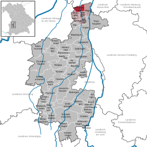
| Location of the municipality of Allmannshofen in the Augsburg district | ||
  |
||


Allmannshofen is a municipality and a town in the Swabian district of Augsburg and a member of the Nordendorf administrative community .
geography
location
Allmannshofen is located in the Augsburg region.
Landscapes and parts of the municipality
There is only the Allmannshofen district . There are 5 officially named parts of the municipality (the type of settlement is given in brackets ):
- Allmannshofen ( parish village )
- Hahnenweiler ( hamlet )
- Holzen (parish village)
- Klause ( wasteland )
- Schwaighof (hamlet)
The Brunnenmahdsiedlung is not an officially named part of the municipality.
history
Until the church is planted
Allmannshofen belonged to the Reichsmarschallen von Pappenheim before it passed to the Holzen Monastery in 1688 , which was under the sovereignty of the Augsburg bishopric . Since the Reichsdeputationshauptschluss of 1803 the place belongs to Bavaria. In the course of the administrative reforms in the Kingdom of Bavaria , today's municipality was created with the municipal edict of 1818 .
Population development
- 1910: 608 inhabitants
- 1961: 806 inhabitants
- 1970: 807 inhabitants
- 1987: 715 inhabitants
- 1991: 760 inhabitants
- 1995: 794 inhabitants
- 2000: 829 inhabitants
- 2005: 835 inhabitants
- 2010: 817 inhabitants
- 2015: 854 inhabitants
Between 1988 and 2018, the community grew from 731 to 902 by 171 inhabitants or 23.4%.
politics
mayor
Markus Stettberger (Allmannshofen Electoral Association) has been mayor since May 1, 2020; he was elected with 92.5% of the vote. His predecessors from 2002 to 2020 were Manfred Brummer (Allmannshofen Electoral Association) and Georg Kratzer (Active Citizens) until 2002.
Municipal council
As in 2014, in the local elections on March 15, 2020, only the Allmannshofen electoral association submitted an applicant list, which again received all eight seats in the municipal council. The turnout was 59.7%.
Another member and chairman of the municipal council is the mayor.
coat of arms
The description of the coat of arms awarded in 1964 reads: "Split, in front in silver blue monkshood in three rows, behind in monkshood cut split of gold and red."
Culture and sights
Architectural monuments
Johannimarkt
Every year at Midsummer a traditional fair takes place in the Holzen Monastery: the Johannimarkt .
Economy and Infrastructure
Economy including agriculture and forestry
In 2010 there were 170 people in employment at the place of work subject to social security contributions. There were 256 employees at the place of residence subject to social insurance contributions. In the same year there were 14 farms with an agricultural area of 455 hectares (376 hectares of which were arable land).
traffic
Allmannshofen is served by the following lines in local public transport:
| Association / operator | line | Walkway | Frequency of use |
|---|---|---|---|
| City bus Donauwörth | 3 | Allmannshofen - Mertingen - Auchsesheim - Donauwörth - Zirgesheim | Monday to Friday three times a day, Saturday once a day |
| AVV | 404 | Nordendorf - (Allmannshofen) - Ehingen - Buttenwiesen - Wertingen | Monday to Friday three times a day |
| AVV | 412 | Nordendorf - Blankenburg - Ortlfingen - Ehingen - Allmannshofen | Monday to Friday three times a day |
Web links
- Homepage
- Entry on the coat of arms of Allmannshofen in the database of the House of Bavarian History
- Allmannshofen: Official statistics of the LfStat (PDF; 1.23 MB)
Individual evidence
- ↑ "Data 2" sheet, Statistical Report A1200C 202041 Population of the municipalities, districts and administrative districts 1st quarter 2020 (population based on the 2011 census) ( help ).
- ^ Municipality of Allmannshofen: Mayor & Municipal Council. Retrieved May 10, 2020 .
- ^ Community Allmannshofen in the local database of the Bavarian State Library Online . Bavarian State Library, accessed on August 20, 2019.
- ↑ Augsburger Allgemeine: Johannimarkt attracts with a large selection
Allmannshofen with Hahnenweiler | Wood | Hermitage | Schwaighof

Adelsried | Allmannshofen | Altenmünster | Aystetten | Biberbach | Bobingen | Bonstetten | Diedorf | Spelled shards | Ehingen | Ellgau | Emersacker | Fischach | Gablingen | Gersthofen | Gessertshausen | Dig | Großaitingen | Heretsried | Hiltenfingen | Horgau | Kleinaitingen | Klosterlechfeld | Koenigsbrunn | Kühlenthal | Kutzenhausen | Langenneufnach | Langerringen | Langweid am Lech | Meitingen | Mickhausen | Mittelneufnach | Neusäß | Nordendorf | Oberottmarshausen | Scherstetten | Schwabmünchen | Stadtbergen | Heads of animals | Untermeitingen | Ustersbach | Walkertshofen | Wehringen | Welden | Westendorf | Zusmarshausen
Unregulated areas: Schmellerforst