
Koenigsbrunn
| coat of arms | Germany map | |
|---|---|---|

|
Coordinates: 48 ° 16 ' N , 10 ° 53' E |
|
| Basic data | ||
| State : | Bavaria | |
| Administrative region : | Swabia | |
| County : | augsburg | |
| Height : | 516 m above sea level NHN | |
| Area : | 18.4 km 2 | |
| Residents: | 28,059 (Dec. 31, 2019) | |
| Population density : | 1525 inhabitants per km 2 | |
| Postal code : | 86343 | |
| Area code : | 08231 | |
| License plate : | A , SMÜ, WHO | |
| Community key : | 09 7 72 163 | |
| LOCODE : | DE KGN | |
City administration address : |
Marktplatz 7 86343 Königsbrunn |
|
| Website : | ||
| Mayor : | Franz Feigl ( CSU ) | |
| Location of the city of Königsbrunn in the Augsburg district | ||
  |
||

Königsbrunn is the largest city in the Swabian district of Augsburg .
geography
location
Königsbrunn is located in the east of the Bavarian administrative district of Swabia and borders Upper Bavaria in the southeast . The urban area is located on the Lechfeld , a gravel plain south of Augsburg between the Alpine rivers Lech and Wertach . Königsbrunn borders the former town of Haunstetten in the north , which has been part of Augsburg since 1972.
Community structure
The city of Königsbrunn is not divided into officially named municipal parts.
On the official map you can find the unofficial part of the village Fohlenhof on the eastern border of the municipality. The Lechaumühle already belongs to the neighboring community of Schmiechen in the Aichach-Friedberg district to the east .
history
Königsbrunn is one of the youngest settlements in Bavaria. In 1833 fountains were built on the so-called Hochstiftstraße, in 1836 the first settlers built their houses at this Königsbrunnen in the Bobingen corridor . At the request of the settlers, Königsbrunn was elevated to a municipality on January 7, 1842 and a city in 1967 . However, the corridor of today's Königsbrunn was already populated by Celts and Romans in the Stone Age and Bronze Age.
Prehistory and early history

Numerous archaeological excavations indicate a settlement of the Königsbrunn soil as early as the Neolithic Age (approx. 3000 BC) and the bell-cup culture (approx. 2300 BC). In 1917 a spectacular find from the Early Bronze Age (2200 to 1700 BC) was uncovered in a field in Königsbrunn : a completely preserved stone box made of tufa limestone.
In the late Hallstatt period (500–400 BC), Celts settled in the corridor. So far, around 50 houses in her village have been uncovered. The Celts who lived in this part of Raetia belonged to the tribal group that the Romans called Vindeliker .
With the year 15 BC The rule of the Celts in Raetia ended; their territory went to the Roman Empire . In the same year a legionary camp was founded north of today's Königsbrunn, from which the Roman city of Augusta Vindelicum , today's Augsburg , emerged. Evidence of settlement in Königsbrunn from Roman times is a mithraium and several Roman manors ( villae rusticae ). The Via Claudia Augusta , the most important Roman road north of the Alps , which was expanded in 46 , led directly through Königsbrunn to Augsburg and can still be seen today in individual places. Today Königsbrunn is located on the Via Claudia Augusta long-distance cycle route , which runs along the ancient Roman road of the same name.
middle Ages
As far as is known, settlement in Königsbrunn ended at the end of the Roman era. The Roman manors, the Mithraeum, etc., fell into disrepair and were completely forgotten during the Middle Ages. It is believed that the battle on the Lechfeld (955), in which King Otto and Ulrich von Augsburg defeated the Hungarians, took place at least in part on Königsbrunn territory. This event had significance for the whole of the West. Archaeological finds that would allow a closer localization of the Lechfeld Battle are missing so far.
The Roman road Via Claudia Augusta also fell into disrepair, but its route was still used as an important connecting road. From the 17th century onwards, it was increasingly used between Augsburg and the much-visited pilgrimage site of Klosterlechfeld in the south of Augsburg.
Resettlement

In 1688 a customs house, the "Neuhaus", was built in the south of today's Königsbrunn. At this house a new street branched off at an acute angle from the Via Claudia route that Sigismund von Habsburg had built. From here this road led as a dead straight through Klosterlechfeld to Landsberg. However, since a toll had to be paid for it , it was hardly used and the main traffic continued to prefer the old Roman road.
In the customs house there was also a tensioning station and the “Zum Lechfeldwirt” inn, whose landlord held the cheese, bakery, butchery and brewery rights. Since this was the only inn on the 18-kilometer route between Haunstetten and Klosterlechfeld, business flourished and the landlord was able to build the Nepomuk Chapel on the opposite side of the street in 1734. The Neuhaus is still used today as an inn with a beer garden (Turkish family business "Topkapi").
In 1833, King Ludwig I of Bavaria had three wells dug between Augsburg and Klosterlechfeld to supply the carters and pilgrims. These fountains were soon given the name “King's Fountain” by travelers and residents of the surrounding area. They were a prerequisite for the subsequent settlement and justify the origin of the place name. The coat of arms of the city of Königsbrunn shows a golden royal crown on a red background, which hovers over a silver draw well.
The settlement soon grew into the longest street village in Bavaria (approx. 7 km), as the development took place almost exclusively along the town's main street for a long time. At that time the population of Königsbrunn consisted primarily of farmers who cultivated the barren, stony soil. These were largely second and third sons of farmers from Württemberg and Hesse, the Ries and the Donaumoos, who were able to acquire inexpensive land here.
This is how the Königsbrunn colony came into being on the edge of the Bobinger Flur. In 1842 it was raised to a separate municipality. At that time, 431 people lived in it, including 237 children. Due to the origins of the settlers in the young community, unlike in the predominantly Catholic surrounding area, the two denominations were almost in balance. In Königsbrunn, for example, various facilities were created twice from the start. The first Catholic and the first Protestant school were established in 1846. In 1848 a Protestant cemetery was laid out, in 1850 a Catholic one. The first Catholic church, St. Ulrich, was built in 1855-1858. It was followed by the Evangelical Lutheran Church of St. John in 1859–1861. Both houses of worship have the same architect and are very similar on the outside. They are both right on the old main road, but on different sides of the road and one kilometer apart. In the following decades, the street village of Königsbrunn gradually grew in width.
Growth to the city
The population of Königsbrunn in 1939 was around 3,000. After the Second World War , the number of inhabitants rose sharply due to the allocation of displaced persons . In 1948, the then 24-year-old Fritz Wohlfarth († December 6, 2010) was elected 1st Mayor of Königsbrunn. The youngest mayor of Bavaria at the time had a major influence on the development of the place in the following decades.
Wohlfarth recognized the opportunities in the housing shortage caused by the displaced and promoted housing construction, the building of schools and the settlement of businesses. The König Ludwig School was inaugurated in 1954 and the König Otto School in 1960. The Staatliche Mittelschule (today Via Claudia Realschule) began teaching in 1964 on the premises of the König Ludwig School and moved into its own building on Schwabenstrasse with a swimming pool and gym for the school year 1965/66. The mathematical and natural science high school began its lessons in 1966 and in 1971 moved into its own building with a double gym and swimming pool. When the town was surveyed in 1967, the community had already grown to around 11,000 citizens.
Development as a city

The school for the learning disabled started operations in 1967. This was followed by the construction of a large school center for the disabled with a sports stadium, sports facility and triple gym. With the construction of the “Königstherme” leisure pool (which has since been demolished) and the neighboring ice rink, it was possible in 1985 to create a further attraction in Königsbrunn; In 2001 a multiplex cinema followed with the name "Hollyworld-Movieplex" (today part of the Cineplex network).
The old main street of the former street village was expanded to four lanes in the 20th century and, as part of the federal highway 17 between Augsburg and Landsberg am Lech, cut through the town for decades like an urban motorway . Around 1980 a new motorway-like route of the B 17 was put into operation on the edge of the elevated terrace west of Königsbrunn, which relieved the Königsbrunner Hauptstrasse, henceforth called the “old B 17” to distinguish it. To further calm traffic in the center of Königsbrunn, bypasses were built to the west and east of the city and traffic lights were converted into roundabouts . The middle section of the main street was renamed Bgm.-Wohlfarth-Straße and in 2003 it was reduced from four to two lanes between the two churches of St. Ulrich and St. Johannes. Another sports facility was built in the area west of the Königstherme and the “Ulrichshöhe” viewing and tobogganing hill was created.
Population development
Between 1988 and 2018 the city grew from 20,183 to 28,076 by 7,893 inhabitants or 39.1%.
The population figures from 1842 to 1987 refer to the municipality area from 1987.
| Population development | |||||||||||||
|---|---|---|---|---|---|---|---|---|---|---|---|---|---|
| year | 1842 | 1900 | 1939 | 1950 | 1961 | 1970 | 1987 | 1991 | 1995 | 2000 | 2005 | 2010 | 2015 |
| Residents | 431 | 1,954 | 3,026 | 4,564 | 7,215 | 12,796 | 19,231 | 22.607 | 25,038 | 26,539 | 27,551 | 27.406 | 27,772 |
politics

City council
Allocation of seats in the 30-member city council (as of local elections 2020):
- CSU : 12 seats
- GREEN : 5 seats
- Free voter group: 5 seats
- SPD : 3 seats
- FDP / Citizens' Forum: 2 seats
- AfD: 2 seats
- Citizens' Movement Königsbrunn eV: 1 seats
mayor
The following list contains the (1st) mayors of Königsbrunn since the municipality was founded:
- 1842: Michael Vogel
- 1842–1844: Philipp Bork
- 1844: Isidor Kögel
- 1844–1847: Anton Hadereker
- 1847–1850: Anton Waldmeyer
- 1850–1851: Ignaz Regnier
- 1851–1854: Sebastian Benz
- 1854–1857: Jakob Wahl
- 1857-1866: Lucian Luger
- 1866–1874: Johann Rager
- 1874: Kaspar Schabert
- 1874–1900: Matthias Wahl (son of Jakob Wahl)
- 1900–1911: Johannes Wahl (son of Matthias Wahl)
- 1912–1924: Jakob Pfitzenmaier
- 1935–1945: Jakob Schreijak
- 1945: Hermann Herget
- 1945–1948: Xaver Salvamoser
- 1948–1984: Fritz Wohlfarth (FWG, from 1956 CSU)
- 1984–1996: Adam Metzner (CSU)
- 1996-2014: Ludwig Fröhlich (CSU, from 2013 FWG)
- since 2014: Franz Feigl (CSU)
Twin cities
![]() Croatia : Königsbrunn has been the twin town of Rab on the island of Rab since 1996 .
Croatia : Königsbrunn has been the twin town of Rab on the island of Rab since 1996 .
Culture and sights


Attractions
- Königsbrunn Archaeological Museum
- Mithraeum (in the city cemetery)
- Lechfeld Museum (folklore collections with the home parlor of the residents of Liebenau in northern Bohemia, who were expelled in 1945/1946, today's Hodkovice nad Mohelkou in the Czech Republic. See also: Heimatstube Reichenberg in Augsburg)
- Königsbrunn Natural History Museum ( Dr. Fischer Natural Science Collection )
- Mercateum (largest historical globe in the world)
For many years the “Königstherme” leisure and recreational pool (1984–2015) was the city's greatest attraction with over 100,000 visitors a year at times.
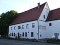
The Neuhaus, the oldest house in Königsbrunn

The Nepomuk Chapel

Ortisei
St. John


Nature and water
- Königsbrunner Heide , Lechtalheiden (in Augsburg city area)
- Ilsesee (in Augsburg city area)
- Gymnasium pond, house manager pond, Hermann pond, Hintersee, Kringweiher, Petri pond
- Lech , Mandicho Lake (no point of contact with Königsbrunn city area)
- Lochbach (at no point crosses Königsbrunn city area)
- Auensee in the Lechauwald near Unterbergen near Lochbachanstich (on Schmiechener municipality area)
- Various fish ponds in the south of the city, e.g. B. Römersee, Alemannensee (both in the municipality of Oberottmarshausen)
Architectural monuments
Churches
- catholic parish church St. Ulrich
- Catholic parish church of the Divine Providence , built 1966–1971 by Justus Dahinden
- Catholic parish church Maria unterm Kreuz
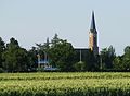
- Protestant Church of St. John
The three Catholic parishes have been run in a parish community since autumn 2004 .
Religions
About half of the residents of Königsbrunn are Roman Catholics , just under a quarter Protestant . Another quarter are members of another religion or are non-denominational . The Wat Phra Dhammakaya Bavaria , a center of the Buddhist Dhammakaya sect from Thailand, has been located in Königsbrunn since 2008 .
Sports
- DEC Tigers Königsbrunn (women's ice hockey, 1987-2006)
- EHC Königsbrunn (ice hockey, founded in 1951 as TSV Königsbrunn , since 1991 ESV Königsbrunn , since 2013 EHC Königsbrunn )
- Königsbrunn Ants (American football, founded 1983 as Augsburg Ants , since 1987 in Königsbrunn)
- Table tennis department of TSV Königsbrunn (founded 1953, currently (2018/2019) renowned TT Bayern league; license holder Sport Pro Gesundheit)
Puzzle days
On September 26, 2004, the city of Königsbrunn, in cooperation with the Ravensburger AG company, organized the 1st German Puzzle Day and achieved an entry in the Guinness Book of Records for the world record in laying the longest puzzle chain.
On September 17, 2006, Königsbrunn competed against the city of Buxtehude on the 2nd German Puzzle Day . Both cities were supposed to lay 5000 puzzles of various sizes in five hours. With 2.5 km of puzzles, Königsbrunn surpassed the city of Buxtehude by 600 m. Almost 1 million valid puzzle pieces were rated, over 90 percent of the 5000 puzzles were completed on time, which resulted in another entry in the Guinness Book of Records.
Economy and Infrastructure
education
- 3 primary schools
- 2 middle schools
- secondary school
- high school
- professional school
- Fritz Felsenstein School Support Center
- "Fountain School" support center
- Special educational support center "Christophorus School"
traffic
Königsbrunn is located on federal highway 17 south of Augsburg. In about 15 minutes you can reach the center of Augsburg, in 20 minutes the federal autobahn 8 Stuttgart-Munich or the federal autobahn 96 Lindau-Munich, in just under 30 minutes the airport Augsburg or the Ammersee , in 45 minutes the " Legoland " Günzburg and in about an hour from Munich and Munich Airport .
Königsbrunn is the largest Bavarian city without a connection to the rail network. The nearest train stations are in Augsburg , Mering , Bobingen and Oberottmarshausen . Local public transport in Königsbrunn is therefore limited to the AVV (Augsburg Tariff and Transport Association) buses . The 733 buses commute between Augsburg-Haunstetten Nord (final stop of tram line 2 ) and Königsbrunn. With additional buses on line 734, this section of the route runs every 15 minutes during rush hour. Line 735 connects Königsbrunn with Haunstetten-West (final stop of tram line 3). The only connection with the center of Augsburg without changing trains is with the express bus line 740 between Augsburg main station and Königsbrunn via B 17. There is also a bus connection between Königsbrunn and Mering station (line 100) and a connection to Bobingen station with line 735.
The planned extension of Augsburg tram line 3 from the current terminus at Haunstetten-West to the city center of Königsbrunn has been designed for more than 30 years, but has not yet been built. The planned tram route has been kept free in terms of urban planning and a larger bus transfer junction "Center" has already been built at the planned tram terminus at the Königstherme, which can later be used as a tram stop without major structural changes.
Authorities and organizations with security tasks ( BOS )
police
The responsible police station for Königsbrunn is the police station Bobingen .
Ambulance service
Ambulances from Bobingen, Augsburg-Haunstetten and Mering usually come to Königsbrunn . The former rescue station in Königsbrunn was dissolved due to the trend and structural analysis of the rescue service in Bavaria (TRUST report). After another expert opinion, it was determined that from October 1, 2020, an ambulance will again be available from 7:00 a.m. to 12:00 a.m. in the Königsbrunn city area. This is operated by the private rescue service company Bäuerle Ambulanz.
fire Department
The Königsbrunn volunteer fire brigade was founded in 1873.
At the fire station volunteer firefighters Königsbrunn are erasing and a Rüstzug stationed. The total of 10 vehicles of the Königsbrunn volunteer fire brigade are alerted , like the rescue service, via the integrated control center in Augsburg. The primary area of operation is the city of Königsbrunn. However, on request, the fire brigade will also move out to provide support to Bobingen, Oberottmarshausen or Mering, among others.
On average, the Königsbrunn fire brigade is alerted to 250 to 300 missions a year.
Personalities

- Eberhard Peiker (* 1943), actor
- Wolfgang Knabe (* 1950), cultural scientist and expedition leader
- Armin Strohmeyr (* 1966), writer, winner of the City of Königsbrunn Culture Prize (2005)
- Darius Kampa (* 1977), soccer goalkeeper, former licensed player, today coach
- Aleksander Polaczek (* 1980), national ice hockey team player, 2003–2018 DEL, most recently there as a striker with the Augsburg Panthers
- Markus Thorandt (* 1981), footballer, 2009–2015 Bundesliga player at FC St. Pauli
- Steffen Tölzer (* 1985), national ice hockey team player, defender for the Augsburg Panthers
- Markus Keller (* 1989), professional ice hockey player, goalkeeper for the Kassel Huskies
- Jerome Flaake (* 1990), ice hockey player, striker for the Düsseldorfer EG
Web links
- Literature by and about Königsbrunn in the catalog of the German National Library
- Entry on the Koenigsbrunn coat of arms in the database of the House of Bavarian History
- City of Königsbrunn
- Königsbrunn: Official statistics of the LfStat (PDF; 1.2 MB)
Individual evidence
- ↑ "Data 2" sheet, Statistical Report A1200C 202041 Population of the municipalities, districts and administrative districts 1st quarter 2020 (population based on the 2011 census) ( help ).
- ↑ Bavarian State Office for Statistics and Data Processing (Ed.): Official local directory for Bavaria, territorial status: May 25, 1987 . Issue 450 of the articles on Bavaria's statistics. Munich November 1991, DNB 94240937X , p. 391 ( digitized version ).
- ^ Official topographic map in the Bavaria Atlas
- ^ City history of Königsbrunn
- ↑ Bavarian State Office for Statistics and Data Processing (Hrsg.): The municipalities of Bavaria according to the territorial status May 25, 1987. The population of the municipalities of Bavaria and the changes in the acquisitions and territory from 1840 to 1987 (= contributions to Statistics Bavaria . Issue 451). Munich 1991, p. 122 , urn : nbn: de: bvb: 12-bsb00070717-7 ( digitized ).
- ↑ Augsburger Allgemeine: Why a restart of the Königstherme is unlikely . In: Augsburger Allgemeine . ( augsburger-allgemeine.de [accessed on February 20, 2017]).
- ↑ Willy Behrendt and Albert Teichner: Königsbrunn - the city on the Lechfeld , Königsbrunn, 1984, ISBN 978-3-924619-00-8 .
- ^ Mourning for Fritz Wohlfarth . Augsburger Allgemeine from December 8, 2010, accessed on September 18, 2018.
- ↑ Pictures from the former Königstherme on facebook
- ↑ former advertising film of the Königstherme
- ↑ Try to find comrades-in-arms to preserve the Königstherme with souvenir pictures
- ^ Catholic community .
- ↑ Evangelical Congregation .
- ^ Fritz Felsenstein School .
- ↑ Bäuerle & Co. Ambulanz OHG. Retrieved June 4, 2020 .
- ↑ Königsbrunn volunteer fire department .

Adelsried | Allmannshofen | Altenmünster | Aystetten | Biberbach | Bobingen | Bonstetten | Diedorf | Spelled shards | Ehingen | Ellgau | Emersacker | Fischach | Gablingen | Gersthofen | Gessertshausen | Dig | Großaitingen | Heretsried | Hiltenfingen | Horgau | Kleinaitingen | Klosterlechfeld | Koenigsbrunn | Kühlenthal | Kutzenhausen | Langenneufnach | Langerringen | Langweid am Lech | Meitingen | Mickhausen | Mittelneufnach | Neusäß | Nordendorf | Oberottmarshausen | Scherstetten | Schwabmünchen | Stadtbergen | Heads of animals | Untermeitingen | Ustersbach | Walkertshofen | Wehringen | Welden | Westendorf | Zusmarshausen
Unregulated areas: Schmellerforst