
High school pond
| High school pond | ||
|---|---|---|

|
||
| Geographical location | Koenigsbrunn , Bavaria | |
| Tributaries | Groundwater / precipitation | |
| Drain | Groundwater | |
| Places on the shore | Koenigsbrunn | |
| Data | ||
| Coordinates | 48 ° 16 '14 " N , 10 ° 52' 53" E | |
|
||
| length | approx. 100 m | |
| width | approx. 50 m | |
|
particularities |
||

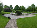
The high school pond is a quarry pond in Königsbrunn . It is located to the west of the grammar school, where it got its name from, in a former gravel pit that was renatured and left to its own devices for decades. The resulting biotope offers a habitat for many birds, insects, fish and amphibians.
The grammar school pond is the only body of water in the inner city of Königsbrunn. In the immediate vicinity there are various attractions for citizens created by the city of Königsbrunn:
- a skate park
- an arboretum
- a Kneipp facility
- a 240 m long, winding barefoot path , "Path of the Senses"
- a herb garden

The high school pond from the east bank
The Kneipp facility
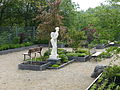
The herb garden with the Chinese flower girl


To the west of the pond is the “Sportpark West” and the viewing and tobogganing hill “ Ulrichshöhe ” (539.90 m above sea level and thus approx. 24 m high) and to the east is the Mercateum .
See also
Web links
- The high school pond in the BayernAtlas