
Mercateum

The Mercateum is the largest globe in the world based on historical cartography .
The Mercateum is an official memorial for the trade relations between Swabia and Franconia on the one hand and India on the other. The name Mercateum stands on the one hand for the topic of trade (from Latin Mercator = trader , merchant), on the other hand for the important cartographer Gerhard Mercator .
After an initial presentation in 2005 on Marstallplatz in Munich on the anniversary of 500 years of trade relations with India (1505-2005), the Mercateum in Königsbrunn in the Augsburg district has its final location in the center of the city on a specially created space between the Königstherme and the Found high school. It was officially opened to the public on May 30, 2008.
The globe

The globe bears a map of the world that the Spanish cosmographer Diego Ribero completed in February / March 1529. It was used by Emperor Charles V to solve the Moluccas question (whether the Indonesian archipelago, then known as the Spice Islands, was part of the Spanish or Portuguese part of the world). It was the first complete world trade map. According to its own description, it contains "everything that has been discovered by the world to date". The last discoveries made by the Spaniards in the Pacific are recorded here up to 1525. The number of landmarks named on the map is estimated at approximately 3,000.
The portolan card drawn on parchment , which originally measures 204.5 cm × 85 cm and is now in the Vatican archives, was converted into a spherical shape true to projection and enlarged by 260 times - a process that only few historical maps do is possible and was undertaken for the first time in this size. When converting a flat, two-dimensional map into a spherical shape, the map projection of the cartographer basically has to be reversed and the map “rectified” in this way.
The 10 meter high structure is a new type of membrane construction . The basic structure is a wooden node-and-bar construction built on a steel frame with a special composite anchor technology that supports the 452 square meter roof cladding. This consists of a two-layer membrane with an air-supported space, which gives a perfect spherical shape on the outside, without the need for an air lock to enter the ball.
The globe stands on a platform surrounded by a pool of water and can be entered through two doors. Inside, stairs connect five levels on which the museum's exhibits are presented. Outside, signs explain the individual hemispheres and special features of Ribero's map. The print on the outer skin of the globe was heavily faded, so that the map was sometimes difficult to read. The color print was therefore renewed in autumn 2016.
The museum

Inside the Mercateum is the main exhibition "From India and from the End of the World", which documents the beginnings and heyday of long-distance trade on the "Road to Italy", which took place in the 16th century from Viborg (Denmark) via Erfurt , Nuremberg , Augsburg and Landsberg led to the Brenner Pass . From there the main traffic ran to Venice , a junction led via Verona and Milan to Genoa and the pilgrimage route to Rome . Between Augsburg and Landsberg, the “road to Italy” that emerged from the Via Claudia Augusta and crossed the corridor of today's city of Königsbrunn was for centuries the most heavily frequented traffic artery in Central Europe. The Augsburg trading dynasties of the Fuggers and Welsers played a central role in this historical long-distance trade.
Other exhibits in the museum show the historical cartography : a copy of the Tabula Peutingeriana , the first road map of Europe by Erhard Etzlaub from 1501, and a replica of Martin Behaims Erdapfel , the oldest surviving terrestrial globe from 1490–1493.

In the Mercateum

The spice route in the 15th and 16th centuries
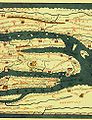
Section of the Tabula Peutingeriana

Map of Europe by Erhard Etzlaub (oriented to the south)

Behaim's potato

"Below deck" in the Mercateum


initiator
The initiator of the Mercateum is the Königsbrunn cultural scientist Wolfgang Knabe , who traced the historical trade routes of the Augsburg and Nuremberg trading houses on land and water on five land and three ship expeditions with his research vessel Mercator .
The construction of the Mercateum was financed by the Bavarian State Chancellery and the City of Königsbrunn.
Mercateum Prize
The Mercateum Prize, established in 2008, is awarded to people who have dedicated themselves in a special way to practice-oriented research on the traces of historical intercontinental trade, to the investigation of long-distance sea or land connections. The previous winners are:
- 2008: Dominique Görlitz , experimental archaeologist
- 2009: Dieter Noli , archaeologist working in the Namib Diamond Restricted Area
- 2012: Burghard Pieske , adventurer and circumnavigator
Web links
Individual evidence
- ↑ Knabe, Wolfgang, Die Alte Strasse and the River, Horb am Neckar 2007, 348 p. 31 illustrations / maps, ISBN 978-3-86595-181-6
- ↑ Hofmann, Till, Abenteuer Handel, Augsburger Allgemeine Zeitung, No. 123, p. 4 Bavaria, May 29, 2008
Coordinates: 48 ° 16 ′ 14.5 " N , 10 ° 53 ′ 8.1" E