
Tagmersheim
| coat of arms | Germany map | |
|---|---|---|

|
Coordinates: 48 ° 49 ' N , 10 ° 58' E |
|
| Basic data | ||
| State : | Bavaria | |
| Administrative region : | Swabia | |
| County : | Danube Ries | |
| Management Community : | Monheim | |
| Height : | 500 m above sea level NHN | |
| Area : | 15.95 km 2 | |
| Residents: | 1098 (Dec. 31, 2019) | |
| Population density : | 69 inhabitants per km 2 | |
| Postal code : | 86704 | |
| Area code : | 09094 | |
| License plate : | DON, Lower Austria | |
| Community key : | 09 7 79 217 | |
| LOCODE : | DE DAY | |
| Community structure: | 2 parts of the community | |
| Address of the municipal administration: |
Kirchplatz 1 86704 Tagmersheim |
|
| Website : | ||
| Mayoress : | Petra Riedelsheimer ( CSU ) | |
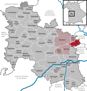
| Location of the municipality of Tagmersheim in the Donau-Ries district | ||
  |
||


.jpg)
Tagmersheim is a municipality in the Swabian district of Donau-Ries and a member of the administrative community of Monheim .
geography
Tagmersheim is located in the Augsburg planning region , approx. 19 km northeast of Donauwörth .
The municipality has two officially named parts of the municipality (the type of settlement is indicated in brackets ):
- Blossenau ( Kirchdorf )
- Tagmersheim ( parish village )
The two places also form the two demarcations that exist in the municipality.
history
Until the church is planted
The Tagmersheim moated castle owned by the von Otting family was destroyed by the Swabian Federation in 1523 and never rebuilt. The owners of the castle had created enemies as supporters of the robber baron Hans Thomas von Absberg , the Otting family died out in the male line in 1578. Tagmersheim was the official seat before 1800 and has belonged to the Counts of Pestalozza since 1672, who also had the high courts . The place was part of the Electorate of Bavaria and formed a closed Hofmark , whose seat was Tagmersheim. In the course of the administrative reforms in the Kingdom of Bavaria , today's municipality was created with the municipal edict of 1818 .
19th and 20th centuries
In 1848 the patrimonial court , which had existed since 1818, was repealed.
From 1965 to 1973 the land consolidation was carried out and at the end a St. James mosaic statue by the artist Peter Recker was erected.
Incorporations
On July 1, 1972, the formerly independent municipality of Blossenau was incorporated.
Population development
Between 1988 and 2018 the municipality grew from 1,069 to 1,088 by 19 inhabitants or by 1.8%.
- 1961: 978 inhabitants
- 1970: 960 inhabitants
- 1987: 1025 inhabitants
- 1991: 1106 inhabitants
- 1995: 1096 inhabitants
- 2000: 1084 inhabitants
- 2005: 1070 inhabitants
- 2010: 1042 inhabitants
- 2015: 1096 inhabitants
politics
Georg Schnell (FWG) has been mayor since May 1, 2008, replacing Mayor Centa Büttner ( CSU , 24 years in office). He was re-elected on March 16, 2014. Petra Riedelsheimer (CSU) was elected as the new mayor from May 1, 2020 in the local elections on March 15, 2020 ; she was the only applicant. In the municipal council with twelve members, all four parties or electoral group each have three seats in the 2020–2026 term of office: CSU, Tagmersheim Free Voting Group, Blossenau Citizens' Association and Tagmersheimer List.
Architectural monuments
Economy and Infrastructure
Economy including agriculture and forestry
In 2017 there were 187 jobs subject to social security contributions in the municipality. Of the resident population, 461 people were in employment subject to compulsory insurance. The number of out-commuters was 274 higher than that of in-commuters. 10 residents were unemployed. In 2016 there were 14 farms; In 2003 there were still 26. 689 hectares of the community area were used for agriculture. 513 hectares were arable land and 177 hectares of permanent grassland.
education
In 2018 there were the following institutions:
- a day-care center with 54 places and 46 children
- an elementary school with three teachers, three classes and 62 students
Personalities
- Herbert Lang (* 1936), pastor and historian, was born and raised in the village.
- Doris Schröder-Köpf (* 1963), German journalist and book author, grew up here.
Web links
- Official website
- Tagmersheim: Historical search for traces - The Young Palatinate in Bavaria (House of Bavarian History)
- Entry on the coat of arms of Tagmersheim in the database of the House of Bavarian History
Individual evidence
- ↑ "Data 2" sheet, Statistical Report A1200C 202041 Population of the municipalities, districts and administrative districts 1st quarter 2020 (population based on the 2011 census) ( help ).
- ^ Tagmersheim community in the local database of the Bavarian State Library Online . Bayerische Staatsbibliothek, accessed on September 1, 2019.
- ↑ Church newspaper for the diocese of Eichstätt from August 5, 1973, p. 6
- ^ Wilhelm Volkert (ed.): Handbook of Bavarian offices, communities and courts 1799–1980 . CH Beck, Munich 1983, ISBN 3-406-09669-7 , p. 450 .

Alerheim | Amerdingen | Asbach-Bäumenheim | Auhausen | Buchdorf | Daiting | Deiningen | Donauwörth | Ederheim | Ehingen am Ries | Forheim | Fremdingen | Fünfstetten | Genderkingen | Hainsfarth | Harburg (Swabia) | Hohenaltheim | Holzheim | Huisheim | Kaisheim | Maihingen | Marktoffingen | Marxheim | Megesheim | Mertingen | Mönchsdeggingen | Monheim | Möttingen | Munningen | Munster | Niederschönenfeld | Nordlingen | Oberndorf am Lech | Oettingen in Bavaria | Otting | Rain | Reimlingen | Rögling | Tagmersheim | Tapfheim | Wallerstein | Wechingen | Wemding | Wolferstadt
Unregulated areas: Dornstadt-Linkersbaindt | Ester wood