
Munningen
| coat of arms | Germany map | |
|---|---|---|

|
Coordinates: 48 ° 55 ' N , 10 ° 36' E |
|
| Basic data | ||
| State : | Bavaria | |
| Administrative region : | Swabia | |
| County : | Danube Ries | |
| Management Community : | Oettingen in Bavaria | |
| Height : | 415 m above sea level NHN | |
| Area : | 22.77 km 2 | |
| Residents: | 1745 (Dec. 31, 2019) | |
| Population density : | 77 inhabitants per km 2 | |
| Postal code : | 86754 | |
| Primaries : | 09082, 09092 | |
| License plate : | DON, Lower Austria | |
| Community key : | 09 7 79 188 | |
| Community structure: | 7 parts of the community | |
| Address of the municipal administration: |
Raiffeisenstrasse 3 86754 Munningen |
|
| Website : | ||
| Mayor : | Dietmar Höhenberger | |
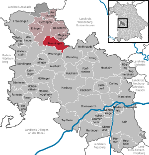
| Location of the municipality of Munningen in the Donau-Ries district | ||
  |
||

Munningen is a municipality in the Swabian district of Donau-Ries and a member of the Oettingen administrative community in Bavaria .
geography
location
Munningen is located on the Wörnitz , between Oettingen in Bavaria in the north and Wechingen in the south.
Landscapes and parts of the municipality
The municipality consists of three districts and has seven officially named municipality parts (the type of settlement is indicated in brackets ):
- District Munningen with Faulenmühle ( wasteland ), Munningen ( Kirchdorf ) and Ziegelmühle (wasteland)
- Landmark Laub with Eulenhof (wasteland) and Laub (parish village)
- District Schwörsheim with Haid ( village ) and Schwörsheim (Kirchdorf)
history
Until the church is planted
The village has, starting from the Roman fort Losodica , Roman origins. The place was first mentioned in documents in 1265. In the Middle Ages it was under the territorial rule of the Counts of Oettingen . In the course of the Reformation and the division into two lines of the House of Oettingen, the village was denominationally divided around 1550. With the Rhine Confederation Act 1806, the place came to the Kingdom of Bavaria . In the course of the administrative reforms in Bavaria, the municipality of Munningen was created with the municipal edict of 1818 .
Incorporations
On May 1, 1978, the former municipalities of Laub and Schwörsheim were incorporated as part of the regional reform .
Population development
Between 1988 and 2018 the municipality grew from 1,671 to 1,733 by 62 inhabitants or 3.7%.
- 1987: 1654
- 1995: 1762
- 2000: 1823
- 2005: 1796
- 2010: 1767
- 2015: 1797
politics
mayor
Dietmar Höhenberger has been the mayor of Munningen since May 2014. He won the election with 50.49% of the vote against Christoph Schmid, who scored 49.51%. Expressed in votes, Höhenberger had 12 more votes. In the local elections on March 15, 2020 , he was the only candidate to be re-elected with 91.9% of the valid votes.
Municipal council
The town council includes the mayor and twelve other members. In the 2020–2026 term of office, the Free Voting Community / United Voting Community Munningen, Laub Voting Community and Village Community / Free Voting Community Schwörsheim each provide four municipal councils.
Attractions

The crooked church tower is the landmark of Munningen. From the top to the bottom, the tower of the Catholic parish church of St. Peter and Paul stands approximately 1.47 m from the perpendicular. The Catholic Church was renovated in 2007. The relics , which could not be placed in the altars for decades, were solemnly reinstated.
Architectural monuments
traffic
Since December 2009 the state road St 2221 has passed Munningen in the west and connects Oettingen and Wechingen directly. Munningen is connected to federal highway 466 via the DON 17 district road , which cuts the new bypass in a roundabout . A local connecting road to the east leads to Megesheim .
The bus lines 740 and 750 of the Donau-Ries transport association connect Munningen with the surrounding villages and the Hoppingen , Möttingen and Nördlingen stations on the Donauwörth – Aalen railway line on weekdays .
Web links
- Homepage of Munningen
- Entry on the coat of arms of Munningen in the database of the House of Bavarian History
- Munningen: Official statistics of the LfStat
- Munningen in the location database of the Bayerische Landesbibliothek Online . Bavarian State Library
Individual evidence
- ↑ "Data 2" sheet, Statistical Report A1200C 202041 Population of the municipalities, districts and administrative districts 1st quarter 2020 (population based on the 2011 census) ( help ).
- ^ Munningen community in the local database of the Bavarian State Library Online . Bayerische Staatsbibliothek, accessed on September 1, 2019.
- ^ Federal Statistical Office (ed.): Historical municipality directory for the Federal Republic of Germany. Name, border and key number changes in municipalities, counties and administrative districts from May 27, 1970 to December 31, 1982 . W. Kohlhammer, Stuttgart / Mainz 1983, ISBN 3-17-003263-1 , p. 793 .

Alerheim | Amerdingen | Asbach-Bäumenheim | Auhausen | Buchdorf | Daiting | Deiningen | Donauwörth | Ederheim | Ehingen am Ries | Forheim | Fremdingen | Fünfstetten | Genderkingen | Hainsfarth | Harburg (Swabia) | Hohenaltheim | Holzheim | Huisheim | Kaisheim | Maihingen | Marktoffingen | Marxheim | Megesheim | Mertingen | Mönchsdeggingen | Monheim | Möttingen | Munningen | Munster | Niederschönenfeld | Nordlingen | Oberndorf am Lech | Oettingen in Bavaria | Otting | Rain | Reimlingen | Rögling | Tagmersheim | Tapfheim | Wallerstein | Wechingen | Wemding | Wolferstadt
Unregulated areas: Dornstadt-Linkersbaindt | Ester wood