Eberhardsreuth
|
Eberhardsreuth
Schönberg market
Coordinates: 48 ° 48 ′ 57 ″ N , 13 ° 21 ′ 31 ″ E
|
||
|---|---|---|
| Height : | 475 m | |
| Incorporation : | May 1, 1978 | |
| Postal code : | 94513 | |
| Area code : | 08554 | |
|
Location of Eberhardsreuth in Bavaria |
||
|
The branch church of St. Michael
|
||

Eberhardsreuth is a district of the market Schönberg in the Lower Bavarian district of Freyung-Grafenau . Until 1978 it formed an independent municipality.
location
The church village is located directly on the federal highway 85 between the towns of Schönberg and Tittling . The salt road Gulden Stras used to cross the town. One kilometer east of the village is the special airfield airfield Elsenthal-Grafenau .
history
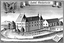
Already in 1263 the Passau bishop Otto von Lonsdorf transferred a Eberhartsdorf to Heinrich von Harchaim as a fief. 1349 "Ewerhartstorf" is mentioned, 1423 "Eberharzrewt", 1436 "Eberhartzrewt", 1488 "Eberhatzreit" and 1500 "Eberezreith". Eberhardsreuth Castle and Hofmark , located here, have seen numerous changes of ownership. In 1582 Eberhardsreuth consisted of a palace, courtyard tavern, brewery, administrative building and three subjects, each with a building tenancy.
In 1648, the last year of the Thirty Years War , the village was devastated by Swedish troops. In 1820 the patrimonial court Eberhardsreuth II class was formed, but in 1848 it was repealed. In 1854 Joseph Klämpfl counted 26 houses in "Eberhardsreut" in addition to the castle. In 1864 the Passau merchant Franz Xaver Rosenberger , known as a friend of Adalbert Stifter and owner of Stifter's summer residence Rosenbergergut, bought the castle from Karl Hueb. Even after that, the castle often changed hands. In 1883, the villagers founded the local volunteer fire department. On May 1, 1978, Eberhardtsreuth was incorporated into the Schönberg market as part of the regional reform in Bavaria .
Attractions
- The castle, which is now partially hidden behind trees, goes back to a medieval moated castle. It consists of four two-story wings that enclose a small, rectangular courtyard. The Maria Himmelfahrt castle chapel dates from the 18th century. It was expanded in 1820 and consecrated on July 27, 1841 by Passau Bishop Heinrich von Hofstätter . The castle serves as a residential building and is not open to the public.
- The Church of St. Michael , a branch church of the parish of Schönberg, was built in 1931.
societies
- Ladies gymnastics group Eberhardsreuth
- Eberhardsreuth volunteer fire department
- Schloßschützen Eberhardsreuth
- Eberhardsreuth soldiers and warriors' association
- BRK readiness Eberhardsreuth
literature
- Joseph Klämpfl: The former Schweinach and Quinzingau. A historical-topographical description , 1855, reprint 1993, Neue Presse Verlags-GmbH, Passau, ISBN 3-924484-73-2
- District of Freyung Grafenau: The district of Freyung-Grafenau , 1982, ISBN 3-87553-192-2
Individual evidence
- ^ Federal Statistical Office (ed.): Historical municipality directory for the Federal Republic of Germany. Name, border and key number changes in municipalities, counties and administrative districts from May 27, 1970 to December 31, 1982 . W. Kohlhammer GmbH, Stuttgart and Mainz 1983, ISBN 3-17-003263-1 , p. 628 .

