Herzogsreut
|
Herzogsreut
community Hinterschmiding
Coordinates: 48 ° 50 ′ 19 ″ N , 13 ° 38 ′ 36 ″ E
|
|
|---|---|
| Height : | 858 m |
| Incorporation : | January 1, 1978 |
| Postal code : | 94146 |
| Area code : | 08550 |
|
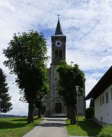
View of Herzogsreut
|
|
Herzogsreut is a district of the Hinterschmiding community in the Lower Bavarian district of Freyung-Grafenau . Until 1875 the spelling was Herzogsreuth .
location
Herzogsreut is located in the Bavarian Forest on an elevation about two and a half kilometers northeast of Hinterschmiding.
history
The Waldhufendorf was founded in 1618 by Archduke Leopold of Austria , the then Prince-Bishop of the Passau Monastery , on the middle branch of the Goldener Steiges . The reason for the establishment was the uprising of the Bohemian estates, against which the Goldene Steig and the border should be secured. Originally the village consisted of 18 settlers. In 1625, the new town almost died out again due to the plague.
It was not until 1644 that the village law letter was issued, which settled border disputes with other villages, determined the locality and established the rights, burdens and duties of the settlers down to the smallest detail. Life in the heroic houses , as the place was popularly known, was arduous for a long time and relied on the meager income from local agriculture.
Herzogsreut had been a separate municipality since the 19th century. The villages Schlichtenberg, Schwarzkopf, Gstöcket, Heldengut and Rotbachau also belonged to it. From an ecclesiastical point of view, originally a branch of the pastoral care district of Freyung , Herzogsreut became a school branch in 1832 . From 1841 to 1843 the modern Romanesque parish church of St. Oswald was built . Herzogsreut has been an independent parish since 1894 . The Philippsreut branch emerged from it in 1928 . Today Herzogsreut is looked after in the parish association with Grainet and Hinterschmiding, pastor has been Dr. Dr. Michael Gnan.
The Herzogsreut volunteer fire brigade was founded in 1880. The first larger school building was built in 1885, the school building was expanded to include two classrooms in 1928/29, and the local brass band was founded in 1908. The painter Hans Turek was born in Herzogsreut in 1921. In 1966 the SC Herzogsreut was founded. In 1969 the elementary school was closed.
The number of overnight stays in the municipality increased from 1,351 in 1960 to 4,205 in 1970. In 1971 a branch of the Raiffeisenbank was opened. On January 1, 1978, Herzogsreut was incorporated into Hinterschmiding as part of the regional reform in Bavaria .
Attractions
→ List of architectural monuments in Hinterschmiding
In addition to the parish church of St. Oswald, which was built between 1841 and 1843, Herzogsreut also has a number of other registered monuments. A former small farm can be found in Hauptstrasse 4. It is a single-storey block building with a half-hipped roof from the first half of the 19th century. In Hauptstrasse 26, a shingled flat saddle roof building from around 1825/40 was a listed building. Not far away are the Wastlhof (Hauptstrasse 37), dating from 1887, and the Gasthof Zur alten Post in Hauptstrasse 43 , whose existence is documented as early as the 17th century. Furthermore, a Waldlerhaus from the first half of the 19th century was under monument protection in Hauptstrasse 69 .
Soil monuments
literature
- The district of Freyung-Grafenau , Verlag Landkreis Freyung-Grafenau, 1982, ISBN 3-87553-192-2 .
Web links
Individual evidence
- ↑ Bavarian State Statistical Office (Hrsg.): Historical municipality register: The population of the municipalities of Bavaria in the period from 1840 to 1952 (= contributions to Statistics Bavaria . Issue 192). Munich 1954, DNB 451478568 , p. 74–75 , urn : nbn: de: bvb: 12-bsb00066439-3 ( digitized version - Wolfstein district, footnote 6).
- ^ Federal Statistical Office (ed.): Historical municipality directory for the Federal Republic of Germany. Name, border and key number changes in municipalities, counties and administrative districts from May 27, 1970 to December 31, 1982 . W. Kohlhammer GmbH, Stuttgart and Mainz 1983, ISBN 3-17-003263-1 , p. 628 .
- ↑ The inn "Zur Alten Post" in the Regiowiki Niederbayern-Altötting, accessed on August 3, 2016


