Plattenhausen bolt
| Plattenhausen bolt | ||
|---|---|---|
|
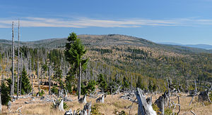
View from Big Rachel |
||
| height | 1372 m above sea level NHN | |
| location |
Freyung-Grafenau district , Bavaria , Germany Modrava , Czech Republic |
|
| Mountains | Bavarian Forest , Bohemian Forest | |
| Coordinates | 48 ° 57 '51 " N , 13 ° 26' 57" E | |
|
|
||
| rock | Gneiss , granite | |
The border between the Freyung-Grafenau district in Bavaria and the Czech Republic runs over the Plattenhausenriegel ( Blatný vrch in Czech ) in the Bavarian Forest , it is located between the Großer Rachel (1453 m) in the west-northwest and the Lusen ( 1373 m ) in the southeast and is according to the current one Topographic map of Bavaria 1372 m above sea level. NHN high; however, most maps show an altitude of 1376 m for the mountain .
The one on the map of Philipp Apian from 1568 as Plattenhausen m. The Plattenhausenriegel drawn in is an elongated ridge across the state border, its inconspicuous summit consists of an approximately 5 m high rock formation. The mountain is located in the core zone of the Bavarian Forest National Park , it can only be reached via the unmarked Grenzsteig from July 15 to November 15 of each year (National Park Ordinance).
On June 20, 1963, two Czechoslovak MiG-15 jet fighters crashed on German territory west of the Plattenhausen bar.
Web links
- Detailed map of Plattenhausenriegel and the surrounding area on: BayernAtlas of the Bavarian State Government ( information )
Individual evidence
- ↑ Height according to: BayernAtlas of the Bavarian State Government ( information ) - Labeling like query (with right click) uniformly provide a value of 1372 m.
- ↑ Plattenhausenriegel and Spitzberg - Forbidden Land. Retrieved May 5, 2017 .
- ↑ Plane crash on Plattenhausenriegel - RegioWiki Niederbayern. Retrieved May 5, 2017 .

