
List of architectural monuments in Gerolzhofen

The monuments of the Lower Franconian town of Gerolzhofen are compiled on this page . This table is a partial list of the list of architectural monuments in Bavaria . The basis is the Bavarian Monument List , which was first drawn up on the basis of the Bavarian Monument Protection Act of October 1, 1973 and has since been managed by the Bavarian State Office for Monument Preservation . The following information does not replace the legally binding information from the monument protection authority. This list reflects the update status from May 1, 2020 and contains 149 monuments.
Ensembles
Old town Gerolzhofen

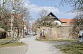
The town of Gerolzhofen ( Lage ) spreads out on the western edge of the Steigerwald in the transition zone to the Gäu landscape, north of the Volkach on slightly undulating terrain. Gerolzhofen was mentioned for the first time between 750 and 779 as a village (villa) in Volkgau, where the Fulda monastery was wealthy. After another mention of 906, documents from the 13th-14th centuries follow. Century. So in 1310 a pastor is called and in 1327 it is called an “oppidum”, and at about the same time as the seat of an archdeaconate. The city seals of 1357 and 1359 indicate the time when Emperor Ludwig the Bavarian raised numerous villages and markets to cities at the request of the sovereign , the Bishop of Würzburg . In 1397 King Wenzel put the city on an equal footing with the imperial cities within the Franconian League of Cities. The center of the town's settlement lies in the area of the former Oberamtshaus or former district administration office, where a fortified manor of the von Fuchs was located and where the prince-bishop's bailiff had sat since 1492 . The village, which was built under the protection of the castle, was expanded into a planned overall complex and, before 1397, received an approximately rectangular fortification with two city gates. The outer city was included in the city fortifications under Bishop Rudolf von Scherenberg. With its double walling, Gerolzhofen is the rarely good example of a concentrically developed complex. The town's layout is based on the grid system with side streets running parallel to the town fortifications in an east-west and north-south direction. This system is penetrated by a diagonal, the main street of the city, which does not lead in a straight line, but with many bends from the southeast to the northwest, extends in the center to the irregularly square market square and at the kinks and acute-angled side streets to smaller special marketplaces . It is particularly striking in the core facility, where it coincides with the north-south and west-east roads leading via Gerolzhofen. But it is also gaining ground in the extended urban area. The important west-east orientation - in the context of an old street from the main stage town of Würzburg, which led via Stegaurach and Bamberg to Hallstadt - becomes clearer after the expansion. The diagonal crossing the city is not only in the course of the west-east-oriented Altstrasse, but also in the course of a connecting route which, older than the city, led from the Franconian settlement group around Herlheim to Schallfeld and Düttingsfeld in the Oberschwarzach region . Furthermore, the old Schweinfurt - Prichsenstadt road should be pointed out, which also cut through the city, but now passes by as an expressway to the east. The diagonal thus combines traffic routes and old roads that are oriented both east-west and north-south. It is represented in the entire walled city area as a sequence of streets and squares. The core area, called the “capital”, which encompasses only a few alleys, has an east-west axis that is marked by the visual relationships between the monumental buildings. All the main buildings of the city are located on or near this axis: The Owl Tower (formerly also Vogteigefranken); the former bailiwick building, the "new bailiwick", built in 1495 as the residence of the prince-bishop's town bailiff and rebuilt between 1600 and 1614; the city parish church, new building of a three-aisled hall church from 1436 with double east tower, extended by two axes to the west by Josef Schmitz from 1899; the town hall, 15th and 16th centuries; the White Tower, 14./16. Century (formerly also the centre's prison) and further away the former Oberamtshaus from 1580, with a former new prison (mid-19th century). These elevated buildings determine the city silhouette, which was disrupted by the demolition of the Zehntstadel (1955) at the Vogteiamt, despite the adaptation of the new building to the original height and mass development. In the core area is also the hospital, founded in 1402 by a couple from Schweinfurt, which was re-established in 1616 under Prince-Bishop Julius Echter ; the existing hospital church was not built until 1710. The fact that three-storey town houses can only be found on the market square underscores the difference in importance between the center and the suburbs, which also corresponds to the topographical gradient. The completely different character of the suburbs has remained particularly clear on Rügshofer Straße. A quarter of the arable bourgeois character has been preserved here. Relatively stately residential buildings line the market-like street space, behind it are the stables and a parallel row of barns, corresponding to the course of the outer city wall, up to which the house gardens extend. Behind the properties facing Salzstrasse, the arrangement is similar; between two rows of rear buildings, a strip of garden culture is kept free in the area of the former trench. Steingrabenstrasse is also characterized by arable bourgeoisie, but more modest, although there was a monastery courtyard here (a Renaissance double portal at Steingrabenstrasse 47 has still been preserved). The southern Spitalvorstadt is characterized by its relationship to the Oberamtshaus, the former Ökonomiehof and the associated Vorwerke of the von Fuchs were located here. The bath house and the communal brewery from 1603 (in the ditch at the southeast corner of the inner fortifications) were located here. The expansion of the Spitalvorstadt also shows that the Mühlbach and its mill were specifically included in the city wall. In the south of Grabenstrasse, as with Rügshofer Strasse, a row of barns has been preserved, which is assigned to the arable bourgeois houses parallel to the street or wall. In the outer city area, new street axes break up the floor plan system, which means that the city has received new gate and entrance situations to the historic ones. The continuation of the central axis of Bürgermeister-Weigand-Strasse / Marktplatz / Weisse-Turm-Strasse to the east and west is modern, and a wall breach has also been made in the south for a road that has not been built. The diagonal, the urban development characteristic of which is the staggering, was disturbed by a smooth, rounded development on the corner of Schallfelderstrasse and Bleichstrasse. The structure and extent of the Gerolzhofen ensemble is thus determined by the city map and the fortifications of the 14th and 15th centuries. On the one hand, the empty areas describe the preserved inner ditch areas, on the other hand they are an expression of the arable town , in whose generously dimensioned walling courtyard and garden areas should be included. Due to the heavy losses that Gerolzhofen suffered in 1525 in the Peasants' War and in 1552 in the Second Margrave War, the architecture of the city is essentially post-medieval. With the monumental buildings, which were largely given their design in the time of Prince-Bishop Julius Echter von Mespelbrunn , the city silhouette of Gerolzhofen still represents itself today as the Prince-Bishop 's official and country town. File number: E-6-78-134-1.
City fortifications
Inner city fortifications
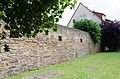
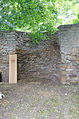
Before 1397, the city was given a roughly rectangular fortification with two city gates: in the SE corner the Spitaltor or Inner Schallfelder Tor, last repaired in 1579 (coat of arms stone preserved in the arcades of the Botanical Garden), and the central gate in the NW corner, last renewed in 1600 (Wappenstein at Marktstrasse 16) (both removed in 1871/77). On all four sides, not only parts of the trench, accessible and visible on Grabenstrasse, but also inaccessible between Rügshofer Strasse and Salzstrasse, have been preserved, but also remains of walls and towers. The walls are partially built into houses. Two stately wall towers have been preserved, the Owl Tower in the west and the White Tower in the east. They served to strengthen the western and eastern fronts. File number: D-6-78-134-2. Pictures .
| location | object | description | File no. | image |
|---|---|---|---|---|
| Bürgermeister-Weigand-Strasse 4 ( location ) |
Owl Tower, former bailiff's prison | Square tower of the inner fortifications, 14th century | D-6-78-134-2 |
 more pictures |
| White Tower Street ( location ) |
White Tower | Round tower of the inner city fortifications, 14. – 16. century | D-6-78-134-2 |
 more pictures |
| Grabenstrasse 2 ( location ) |
Tower stump of the inner city fortifications | Two-storey hipped roof building with half-timbered upper storey, the core of the 16th century | D-6-78-134-2 |
 more pictures |
| location | object | description | File no. | image |
|---|---|---|---|---|
| Grabenstrasse ( location ) |
Trench area | From the corner of Spitalstraße to Schulgasse, with remains of the wall
From Schulgasse to Breslauer Straße, with remains of the wall |
D-6-78-134-42 |
 more pictures |
Outer city fortifications around Zehnt- and Spitalvorstadt
The outer city with the tenth and hospital suburbs was included in the city fortifications under Bishop Rudolf von Scherenberg and renewed as a four-gate complex with the Frankenwinheimer Tor in the west (new building in 1568) and the Rügshofer Tor in the northeast corner (1625 under Prince-Bishop Philipp Adolf von Ehrenberg ), the Dingolshausen gate in the east (coat of arms stone from 1548 preserved in the Braugäßchen) and the outer Schallfelder gate in the south (end of the 15th century under Prince-Bishop Rudolf von Scherenberg). The gates have come off, but long-drawn lines of walls in the north, east and south, and little in the west, with numerous wall towers or tower stumps have been preserved. In addition to openings at the lost gate, numerous openings for streets have been created. File number: D-6-78-134-3. Starting in the south on Schallfelder Straße, the outer city fortifications consist of the following parts. In the section from the abandoned Outer Schallfelder Tor on Schallfelder Straße to Breslauer Straße are preserved:
- Schallfelder Straße 20, 22, Auf der Weth 5, 7, 11 ( location ): the outer city wall
- On the Weth 13 ( location ): wall tower
- On Weth 13, 15, 17 ( location ): the outer city wall was moved

Wall move along the Volkach

Wall tower on the Volkach

The wall at the Weth


In the section from the breakthrough on Breslauer Strasse to Bürgermeister-Weigand-Strasse have been preserved:
- Am Schießwasen: the outer city wall was moved
- Am Schießwasen 9 ( location ): tower stump of the outer city wall, converted into a residential building
- Am Schießwasen ( location ): the outer city wall with the wall gate, marked "1740"
- Bürgermeister-Weigand-Straße 13 ( location ): The outer city wall was moved
- Bürgermeister-Weigand-Straße 13 ( location ): Bibra Tower, round tower of the outer city fortifications with coat of arms and inscriptions, inscribed "1496"
Wall move at Schießwasen

Tower stump Am Schießwasen 9

Gate at Schießwasen 9

Wall move between Am Schießwasen and Bürgermeister-Weigand-Straße 13

Bibra tower

Wall move north of Bürgermeister-Weigand-Straße 13


In the section from the breakthrough on Bürgermeister-Weigand-Strasse to Bahnhofstrasse, the following are preserved:
- Bürgermeister-Weigand-Straße 14 ( location ): tower stump of the outer wall ring, second half of the 15th century, converted into a modern residential building
- Bürgermeister-Weigand-Straße 14 ( location ): a short section of the outer city wall expanded

Tower stump at Bürgermeister-Weigand-Strasse 14

Wall move at Bürgermeister-Weigand-Strasse 14


In the section from the lost Winheimer Tor from Bahnhofstrasse to Entengasse, the following are preserved:
- Bahnhofstrasse 18 ( location ): remainder of the outer city wall
- Dreimühlenstraße, along the street between Bahnhofstraße and Entengasse: remains of the city wall of the outer fortifications
- Entengasse 13 ( location ): Round defense tower on the northwest corner of the outer city fortifications, marked "1489"
- Dreimühlenstraße, along the street between Bahnhofstraße and Entengasse: remains of the city wall of the outer fortifications
Wall of the outer city wall at Bahnhofstrasse 18

Wall tower Entengasse 13

Wall move on Dreimühlnstrasse


In the section from the breakthrough on Entengasse to Rügshöfer Straße:
- Entengasse 8 ( location ): wall tower of the outer city fortifications, second half of the 15th century
- Nördliche Allee, along Nördliche Allee: the wall of the outer city fortifications
- Nördliche Allee, along the south side of the street: the walls of the outer city fortifications, second half of the 15th century
- Nördliche Allee, Entengasse 4: Remnants of the tower of the outer city fortifications, second half of the 15th century
- Nördliche Allee, along the south side of the street: the walls of the outer city fortifications, second half of the 15th century
- Nördliche Allee, Rügshöfer Straße 3: Remnants of the tower of the outer city fortifications, second half of the 15th century
- Nördliche Allee, along the south side of the street: the walls of the outer city fortifications, second half of the 15th century
- Nördliche Allee, Rügshöfer Straße 17: Remnants of the tower of the outer city fortifications, second half of the 15th century
- Nördliche Allee, along the south side of the street: the walls of the outer city fortifications, second half of the 15th century
- Nördliche Allee, Rügshöfer Straße 37: Remnants of the tower of the outer city fortifications, second half of the 15th century
- Nördliche Allee, along the south side of the street: the walls of the outer city fortifications, second half of the 15th century

Wall tower

Wall move to Nördliche Allee
Wall move to Nördliche Allee


The city wall has come down from the abandoned Rügshöfer Tor on Rügshöfer Strasse and Östliche Allee 10. In the section from Steingrabenstraße 29 to Jahnstraße are preserved:
- Ostliche Allee 10 ( location ): Scherenberg tower, round tower of the outer city fortifications, second half of the 15th century
- Ostliche Allee ( location ): Wall of the outer city fortifications, second half of the 15th century

Scherenberg Tower

Wall of the outer city fortifications, Ostliche Allee


In the section from Jahnstraße to Dingolshäuser Straße are preserved:
- Ostliche Allee ( location ): Wall of the outer city fortifications, second half of the 15th century

Wall of the outer city fortifications, Ostliche Allee

In the section from the defunct Dingolshäuser Tor on Dingolshäuser Straße to Bleichstraße are preserved:
- Bleichstrasse 27 ( location ): Wall of the outer city fortifications, second half of the 15th century
In the section from the breakthrough on Bleichstrasse to Schallfelder Strasse have been preserved:
- Bleichstraße 20 ( location ): Wall of the outer city fortifications, second half of the 15th century
- Bleichstrasse 20, in the southeast corner of the outer city fortifications ( location ): wall tower
- Bleichstrasse 20, 18, 16 ( location ): Wall of the outer city fortifications, second half of the 15th century
- Bleichstraße 14 ( location ): wall tower
- Bleichstraße 10, 8, 6, Schallfelder Straße 11: the outer city wall was moved

Wall of the outer city fortifications at Bleichstrasse 20

South-eastern wall tower

Wall of the outer city fortifications at Bleichstrasse 16, 18


Architectural monuments according to districts
Gerolzhofen
| location | object | description | File no. | image |
|---|---|---|---|---|
| Am Schießwasen 2; Corner of Kolpingstrasse ( location ) |
Memorial stone in memory of a murdered woman | Inscribed "1925" | D-6-78-134-4 | |
| Au, on Weisse-Marter-Weg ( location ) |
Wayside shrine | Table base with column and two-sided top, crucifixion with assistant figures, on the reverse the Holy Family, side figures of Saint Michael and Saint Andrew, neo-baroque, inscribed "1907" | D-6-78-134-140 | |
| Au, on the SW 37 to Brünnstadt ( location ) |
Floor cross | Sandstone crucifix, inscribed "1923" | D-6-78-134-252 | |
| On the Weth 1 ( location ) |
Residential stable house | Ground floor gable roof building with plastered half-timbered gable, 18th century | D-6-78-134-7 |
 more pictures |
| On the Weth 1 ( location ) |
Gate | Inscribed "1763" with a relief of the fourteen helpers in need | D-6-78-134-7 |
 more pictures |
| Bahnhofstrasse 1 ( location ) |
Residential and commercial building | Two-storey eaves saddle roof building with ornamental framework, 17th / 18th centuries century | D-6-78-134-8 |
 more pictures |
| Bahnhofstrasse 1, 3 ( location ) |
Left corner post with Julius Echter coat of arms | Inscribed "1583" | D-6-78-134-9 | |
| Bahnhofstrasse 16 ( location ) |
Residential and commercial building | Two-storey eaves gable roof building with stepped gable on one side, arched gate entrance and ornamental half-timbered upper storey, 17th / 18th century | D-6-78-134-10 |
 more pictures |
| Bahnhofstrasse 18 ( location ) |
Kreuzstein, so-called Wetterstein | Sandstone, cross with quatrefoil and coat of arms, 14th century | D-6-78-134-177 | |
| Bahnhofstrasse 19 ( location ) |
Residential building | Two-storey eaves side building with a hipped roof on one side and late Baroque facade structure, round arched gate passage, 18th century | D-6-78-134-12 |
 more pictures |
| Bahnhofstrasse 21 ( location ) |
Residential building | Two-storey mansard half-hipped roof building with a historicist facade, around 1910/15 | D-6-78-134-14 |
 more pictures |
| Bahnhofstrasse 22 ( location ) |
Residential building | Two-storey mansard roof building with gable and corner bay window, neo-renaissance, inscribed "1901" | D-6-78-134-15 |
 more pictures |
| Bahnhofstrasse 23 ( location ) |
Residential and commercial building | Two-storey mansard roof building, historicist, inscribed "1904" | D-6-78-134-16 |
 more pictures |
| Bahnhofstrasse 23 ( location ) |
Rear building | D-6-78-134-16 |
 more pictures |
|
| Bahnhofstrasse 24 ( location ) |
Residential building | Two-storey mansard hipped roof building with a dwelling, neo-renaissance, inscribed "1898" | D-6-78-134-17 |
 more pictures |
| Bahnhofstrasse 27 ( location ) |
Residential house, former Gasthof Zur Eisenbahn | Two-storey hipped mansard roof with corner emphasis, 1904/05 | D-6-78-134-18 |
 more pictures |
| Berliner Strasse 108 a; Street to Schallfeld, in front of the Leopold furniture hall ( location ) |
Wayside shrine | Pointed-arched tower with crabs, relief of the fourteen saints, neo-Gothic, 19th century | D-6-78-134-134 | |
| On the southern, outer city wall, between Schallfelder and Breslauer Straße ( ) |
Wayside shrine | Inscribed "1789";
not re-qualified, not mapped in the Bavarian Monument Atlas |
D-6-78-134-137 | |
| Bleichstrasse 6 ( location ) |
Residential stable house | Ground floor gable roof building with half-timbered gable, 1700 | D-6-78-134-19 | |
| Bleichstrasse 11 ( location ) |
Former mill | Two-storey half-hipped roof building with protruding half-timbered upper storeys and hipped roof extension connected at right angles, 16th century, ground floor marked "1797" | D-6-78-134-20 |
 more pictures |
| Bleichstrasse 11 ( location ) |
Former mill, outbuilding | 18./19. century | D-6-78-134-20 | |
| Brunnengasse 1 ( location ) |
Former courtyard, so-called White Courtyard | Two-storey, gable-independent half-hipped roof building with half-timbered upper storey, in the core 15th century, inscribed "1784"; to Weisse-Turm-Straße half-timbered gable front and gate entrance covered with arcade | D-6-78-134-22 |
 more pictures |
| Brunnengasse 5 ( location ) |
Former Kalterhaus | Two-story hipped roof building, 1738 | D-6-78-134-24 |
 more pictures |
| Brunnengasse 5 ( location ) |
Former Oberamtshaus | Three-storey gable roof building with volute gables, 1580 | D-6-78-134-23 |
 more pictures |
| Brunnengasse 5; in front of the Oberamtshaus ( location ) |
Well with well house | Inscribed "1586" | D-6-78-134-25 |
 more pictures |
| Bürgermeister-Weigand-Strasse 2 ( location ) |
Community center | Two-storey saddle roof building with half-timbered gable from the 17th / 18th centuries Century, marked "1840" | D-6-78-134-26 |
 more pictures |
| Bürgermeister-Weigand-Strasse 3 ( location ) |
Small house | Ground floor gable-independent half-hipped roof building with half-timbered gable, around 1800 | D-6-78-134-27 |
 more pictures |
| Bürgermeister-Weigand-Strasse 5 ( location ) |
Former bailiwick, later forestry office, now age-appropriate living | Three-storey saddle roof building with tail gables and a polygonal stair tower, around 1600 | D-6-78-134-28 |
 more pictures |
| Bürgermeister-Weigand-Strasse 5 ( location ) |
Inscription plaque on the former bailiwick | Inscribed with the real coat of arms "1614" | D-6-78-134-28 |
 more pictures |
| Dingolshauser Street; Corner An den Torweinbergen ( location ) |
Column shrine | With relief of the crucifixion, side figures of Saint Michael and Saint Sebastian, neo-Gothic, 19th century | D-6-78-134-33 | |
| Near Dreimühlenstrasse; in front of the city wall ( location ) |
Wayside shrine | Column with top, depicting the crucifixion and Christ carrying the cross, inscribed "1722" | D-6-78-134-138 |
 more pictures |
| Dreimühlenstraße 2 ( location ) |
Evangelical Lutheran Parish Church of the Redeemer | Sandstone block construction with polygonal choir closure and roof turrets, in the core construction from 1922 | D-6-78-134-35 |
 more pictures |
| Frankenwinheimer Straße 15 ( location ) |
Former pavement customs house | Single-storey saddle roof building, 1912 | D-6-78-134-163 | |
| Near Grabenstrasse; in the botanical garden ( location ) |
Memorial to the women's uprising of 1945 | Monolith with an abstract relief of the church, 1955 by Erich Leuner | D-6-78-134-159 | |
| Near Grabenstrasse; Arcades "Botanical Garden" ( location ) |
Coat of arms of the former hospital gate | 1597 | D-6-78-134-40 | |
| Grabenstrasse ( location ) |
Fountain of Neptune | Marked "1821", figure renewed | D-6-78-134-118 |
 more pictures |
| Grabenstrasse ( location ) |
Nepomuk figure | Sandstone, mid-18th century | D-6-78-134-158 |
 more pictures |
| Grabenstrasse 5 ( location ) |
Former bath house | Two-storey hipped roof building with half-timbered upper storey, the core of the 16th century | D-6-78-134-1 |
 more pictures |
| Grabenstrasse 45 ( location ) |
Agricultural bourgeoisie | Tailcoat house with high basement, half-timbered, inscribed "1799" | D-6-78-134-41 |
 more pictures |
| Grabenstrasse 45 ( location ) |
Outbuilding, in front of it a wooden cross | Inscribed "1863" | D-6-78-134-41 | |
| Grabenstrasse 45, in front of the adjoining building ( location ) |
Wooden cross | Inscribed "1863" | D-6-78-134-41 | |
| Häfnergasse 3 ( location ) |
Residential building | Two-storey gable-independent steep saddle roof building with half-timbered upper storey, 17th / 18th centuries century | D-6-78-134-43 |
 more pictures |
| Häfnergasse 7 ( location ) |
Residential building | Elongated eaves side house with gate entrance and half-timbered upper floor, dendrochronologically dated 1574 | D-6-78-134-44 |
 more pictures |
| Häfnergasse 7 ( location ) |
Side wing to the house | At the back, with a half-timbered upper floor, dendrochronologically dated 1620 | D-6-78-134-44 | |
| Hunters; south of the road to Frankenwinheim ( location ) |
Wayside chapel | Antoniuskapelle, small solid building with pyramid roof, 19th century | D-6-78-134-135 | |
| Hunters; Extension of Nikolaus-Fey-Strasse, south of Volkachbrücke ( location ) |
Altarpiece base | With cartouche and inscription, inscribed "1753" | D-6-78-134-139 | |
| Hörnau ( location ) |
Wayside shrine | Column with garland capital, top with relief of the crucifix, narrow sides with St. Gertrude and St. Nikolaus (patron saint of the founder), inscription on the reverse, crowned by a trefoil cross, inscribed, 1619; Socket 1975 | D-6-78-134-175 | |
| Kapellenberg, above the Jewish cemetery ( location ) |
Catholic Chapel of St. Gertraud | Small hipped roof building with polygonal choir closure, inscribed "1718"; with equipment | D-6-78-134-131 | |
| Kapellenberg ( location ) |
Jewish Cemetery | Walled complex with Taharahaus , called "1832", renewed in 1924 and grave stones of 19-20. Century | D-6-78-134-132 |
 more pictures |
| Kapellenberg; Lindenbrunnenäcker; near the northwest corner of the Jewish cemetery ( location ) |
Wayside shrine | Low table pedestal with chamfered square shaft and top with the crucifixion of Christ, inscribed "1621" | D-6-78-134-133 | |
| Kirchgasse 2 ( location ) |
Former rectory, now a residential building | Two-storey mansard half-hipped roof building on the eaves, inscribed "1908"; on the site of a previous building from 1604 | D-6-78-134-45 |
 more pictures |
| Kirchgasse 2 ( location ) |
Portal from the old rectory | Inscribed 1604 | D-6-78-134-45 |
 more pictures |
| Kirchgasse 4 ( location ) |
Former St. Johann Baptist cemetery chapel | (Karner), two-storey building with buttresses, 1497; with equipment | D-6-78-134-46 |
 more pictures |
| Kirchgasse 6 ( location ) |
Old sacristan's house | Two-storey hipped roof building, in the core 16./17. century | D-6-78-134-47 |
 more pictures |
| District road SW 37 ( location ) |
Sandstone crucifix | Body, second half of the 19th century (base and cross 1975) | D-6-78-134-176 | |
| Ludwig-Derleth-Straße 2 ( location ) |
Community center | Hipped roof building with mezzanine floor, classicistic, around 1845 | D-6-78-134-48 |
 more pictures |
| Ludwig-Derleth-Straße 4 ( location ) |
Birthplace of Ludwig Derleth | Two-storey gable-independent half-hipped roof house with baroque window frames, inscribed "1752" | D-6-78-134-49 |
 more pictures |
| Ludwig-Derleth-Straße 4 ( location ) |
barn | With a mansard roof, mid-18th century | D-6-78-134-49 | |
| Lülsfelder Weg ( location ) |
Wayside shrine | Strong square shaft with an ogival top, relief of the crucifixion of Christ, 16th century | D-6-78-134-109 |
 more pictures |
| Marketplace; on the southern facade of the parish church ( location ) |
Statue of Maria Immaculata | around 1750 | D-6-78-134-51 |

|
| Marketplace 1 ( location ) |
Church of St. Maria de Rosario and St. Regiswindis | Three-aisled, late Gothic hall church with a pair of east towers, first half of the 15th century (pillar inscription 1436), completed in 1479, restoration and leveling of the towers 1588–1612, western extension 1899–1902 by Josef Schmitz; with equipment | D-6-78-134-50 |
 more pictures |
| Marketplace 1; on the south aisle of the parish church ( location ) |
Wayside shrine-like tomb | Showing the risen Christ in the picture, crowned by a medallion with God the Father in it, inscribed "1662" | D-6-78-134-53 |
 more pictures |
| Marketplace 1; on the south aisle of the parish church ( location ) |
Wayside shrine | With a tabernacle-like essay, 1623 | D-6-78-134-54 | |
| Marketplace 1; on the south aisle of the parish church ( location ) |
Mount of Olives | Around 1500 | D-6-78-134-52 |
 more pictures |
| Marketplace 1; on the south aisle of the parish church ( location ) |
Wayside shrine | Crucifixion in a laurel wreath, inscribed "1701" | D-6-78-134-55 |
 more pictures |
| Marketplace 4 ( location ) |
Community center | Two-storey eaves gable roof construction with protruding half-timbered upper storeys, 15th / 16th centuries century | D-6-78-134-56 |
 more pictures |
| Marketplace 5 ( location ) |
Community center | Two-storey mansard roof building with drilled window frames, upper storey in the core half-timbered, 18th century | D-6-78-134-57 |
 more pictures |
| Marktplatz 8 ( location ) |
Community center | Two-storey mansard roof building with baroque structures, in a corner position, around 1720/30 | D-6-78-134-58 |
 more pictures |
| Marktplatz 9 ( location ) |
Community center | Two-storey, gable-independent half-hipped roof building, plastered framework, 1616 (dendrochronologically dated), core 1490 (dendrochronologically dated) | D-6-78-134-59 |
 more pictures |
| Marktplatz 11 ( location ) |
Community center | Three-story saddle roof house, 18th century; Connected to No. 9 by a 17th century courtyard gate | D-6-78-134-60 |
 more pictures |
| Marktplatz 13 ( location ) |
Residential and commercial building | Pharmacy, three-storey mansard roof building with drilled window frames, 18th century | D-6-78-134-61 |
 more pictures |
| Marktplatz 14 ( location ) |
Community center | Two-storey gable-independent gable roof building with ornamental framework, marked "1747" | D-6-78-134-62 |
 more pictures |
| Marktplatz 18 ( location ) |
Corner house | With a long side front facing Spitalstrasse, plastered half-timbering, 18th century, in the middle of the 14th century, with renovation in 1513 | D-6-78-134-63 |
 more pictures |
| Marktplatz 20 ( location ) |
Former town hall, now museum of local history | Three-storey saddle roof building with stepped gables, late Gothic, 1475 ( dendrochronologically dated ) | D-6-78-134-64 |
 more pictures |
| Marktplatz 20 ( location ) |
Former town hall | Rear kitchen wing with half-timbered upper floor, 1585 | D-6-78-134-64 |
 more pictures |
| Marktstrasse 1 ( location ) |
Petty bourgeoisie | Two-storey gable-independent saddle roof building with plastered half-timbered upper storey, 18th century; Shop fitting, early 20th century | D-6-78-134-65 | |
| Marktstrasse 6 ( location ) |
Community center | Two-story mansard saddle roof building with plastered half-timbered gable, in corner position, 1778 | D-6-78-134-66 |
 more pictures |
| Marktstrasse 7 ( location ) |
Door framing | Drilled, a pretzel in the keystone, inscribed "1743" | D-6-78-134-67 | |
| Marktstrasse 9 ( location ) |
Community center | Two-storey saddle roof building with half-timbered upper storey and drilled frames, marked "1731" | D-6-78-134-68 |
 more pictures |
| Marktstrasse 9 ( location ) |
House figure | Maria Immaculata as Patrona Franconiae, 18th century | D-6-78-134-68 |
 more pictures |
| Marktstrasse 13 ( location ) |
Petty bourgeoisie | Two-story mansard roof building with drilled window frames on the upper floor, 18th century | D-6-78-134-69 |
 more pictures |
| Marktstrasse 15 ( location ) |
Residential and commercial building | Half-timbered gabled house, 18th century | D-6-78-134-71 |
 more pictures |
| Marktstrasse 16 ( location ) |
Coat of arms stone | Sandstone, marked "1600", from the former center gate | D-6-78-134-72 |
 more pictures |
| Marktstrasse 20 ( location ) |
Residential and commercial building | Two-story hipped roof building with drilled window frames on the upper floor, in a corner position, 18th century | D-6-78-134-73 |
 more pictures |
| Marktstrasse 21 ( location ) |
Community center | Two-storey hipped roof building, upper floor plastered half-timbering, 18th century | D-6-78-134-74 |
 more pictures |
| Marktstrasse 21 ( location ) |
House figure | Our Lady, 18th century | D-6-78-134-74 | |
| Marktstrasse 25 ( location ) |
Community center | Two-storey eaves gable roof construction with one-sided half-hipped, arched doorway marked "1706" | D-6-78-134-75 |
 more pictures |
| Nikolaus-Fey-Strasse 10 ( location ) |
Statue | Essay depicting the Holy Trinity in a round arch niche, inscribed "1888" | D-6-78-134-76 | |
| Close to Northern Avenue; in the promenade, in front of the city wall ( location ) |
Pillar shrine | With a four-sided attachment and crowning cross, inscribed "1602" | D-6-78-134-79 |
 more pictures |
| Near Nördliche Allee ( location ) |
Marble figure of Germania | Part of a former war memorial for 1870/71 on the market square, today in front of the city wall | D-6-78-134-80 |
 more pictures |
| Next to Nördliche Allee 1 ( ) |
Column shrine | 17th century; "not re-qualified, not mapped in the Bavarian Monument Atlas" | D-6-78-134-77 | |
| Eastern avenue ( location ) |
Altarpiece | Niche with crucifixion, top with the coronation of Mary, inscribed "1778", renewed | D-6-78-134-32 |
 more pictures |
| Ostliche Allee 19 ( location ) |
villa | Two-storey saddle roof building on a high base, 1926 | D-6-78-134-160 | |
| Rügshöfer Straße 1 ( location ) |
Gasthaus Schwane | Two-storey eaves gable roof construction, round arched gate passage from the construction period bricked up and provided with windows, 17th to 19th century; two inscription panels, one of them marked "1605" | D-6-78-134-84 |
 more pictures |
| Rügshöfer Straße 3 ( location ) |
Residential building | Two-storey mansard roof building with corner pilasters, marked "1818" | D-6-78-134-85 |
 more pictures |
| Rügshöfer Strasse 12; Rügshöfer Straße 14 ( location ) |
Residential building | Two-storey, gable-independent mansard half-hipped roof, archway and outbuilding, late 18th century | D-6-78-134-86 | |
| Rügshöfer Straße 13 ( location ) |
Residential building | Two-storey, gable-independent gable roof building with later added knee floor, late baroque facade design, inscribed "1793" | D-6-78-134-87 |
 more pictures |
| Rügshöfer Straße 15 ( location ) |
Residential building | Two-storey, gable-independent mansard half-hipped roof building with courtyard gate, around 1800 | D-6-78-134-89 |
 more pictures |
| Rügshöfer Straße 16 ( location ) |
Residential building | Two-storey, gable-independent half-hipped roof building with corner pillars, upper storey plastered half-timbering, late 18th century | D-6-78-134-90 |
 more pictures |
| Rügshöfer Straße 18 ( location ) |
Residential and guest house, former brewery inn | Two-storey mansard roof building on the eaves with corner pilasters and drilled window frames, late 18th century | D-6-78-134-91 |
 more pictures |
| Rügshöfer Straße 19 ( location ) |
Agricultural bourgeoisie | Two-storey, gable-independent half-hipped roof building with drilled frames on the ground floor, round-arched courtyard gate, late 18th century | D-6-78-134-92 |
 more pictures |
| Rügshöfer Straße 25 ( location ) |
Residential building | Two-storey gable-independent saddle roof building with half-timbered gable, 17th / 18th centuries century | D-6-78-134-93 |
 more pictures |
| Rügshöfer Straße 30 ( location ) |
Catholic cemetery chapel St. Michael | Saddle roof construction with polygonal choir closure and roof turret, 1736–37; with equipment; walled cemetery with gate from the 17th century | D-6-78-134-94 |
 more pictures |
| Rügshöfer Straße 39 ( location ) |
Coat of arms stone | Originally inscribed "1625" on the former Rügshöfer Tor, the northern gate of the outer city wall | D-6-78-134-95 | |
| Rügshöfer Strasse; Between Rügshöfer Straße u. Bahnhofstrasse ( location ) |
Florian Fountain | Octagonal fountain basin with stele and sandstone figure of St. Florian, figure 18th century (copy) | D-6-78-134-83 |
 more pictures |
| Salzstrasse 2 ( location ) |
Residential and commercial building | Three-storey building with a corner bay window and onion dome, in a corner position, historicistic, around 1900 | D-6-78-134-97 |
 more pictures |
| Salzstraße 3, in the gateway ( location ) |
Old stone cross and Scherenberg coat of arms stone from the former Zenttor | Late medieval | D-6-78-134-98 | |
| Salzstrasse 8 ( location ) |
Old school house | Two-storey, gable-independent half-hipped roof building with half-timbered upper storey, inscription from 1816 | D-6-78-134-99 |
 more pictures |
| Salzstrasse 9 ( location ) |
archway | 17th century | D-6-78-134-100 |
 more pictures |
| Salzstrasse 11 ( location ) |
Catholic rectory | Elongated two-storey eaves gable roof construction with corner pilasters and arched gateway, 1708 | D-6-78-134-101 |
 more pictures |
| Salzstrasse 17 ( location ) |
Residential building | Two-storey, gable-independent saddle roof building with plastered protruding half-timbered upper storey, 16./17. Century; Gate construction made of sandstone ashlar masonry, 19th century | D-6-78-134-102 |
 more pictures |
| Salzstrasse 18 ( location ) |
House figure | Maria Immaculata, 18th century | D-6-78-134-103 | |
| Salzstrasse 21 ( location ) |
Residential building | Two-storey half-hipped roof building with drilled window frames, inscription from 1800 | D-6-78-134-104 |

|
| Salzstrasse 25 ( location ) |
archway | 17./18. century | D-6-78-134-105 |

|
| Schallfelder Straße 1 ( location ) |
Residential building | One and a half storey half-hipped roof building with half-timbering, 17th / 18th centuries century | D-6-78-134-106 |
 more pictures |
| Schallfelder Straße 2 ( location ) |
Community center | Two-storey gable-independent saddle roof building with half-timbered gable, 17th / 18th centuries century | D-6-78-134-38 |
 more pictures |
| Schallfelder Straße 4 ( location ) |
Residential building | Two-storey eaves saddle roof building with half-timbered upper storey, labeled "1822" | D-6-78-134-107 |

|
| Schallfelder Straße 8 ( location ) |
Residential building | Two-storey saddle roof building with half-timbered upper storey, labeled "1586", shop fitting on the ground floor in 1935 | D-6-78-134-108 |

|
| Schuhstrasse 3 ( location ) |
Community center | Two-storey mansard roof building on the eaves, 18th / 19th centuries century | D-6-78-134-110 |

|
| Schuhstrasse 5 ( location ) |
Community center | Two-storey mansard roof building with eaves, marked "1762" | D-6-78-134-111 |

|
| Schuhstrasse 23 ( location ) |
Coat of arms stone | Fall of a renaissance portal, marked "1577"
Crucifixion relief, 17th century |
D-6-78-134-112 | |
| Spitalstrasse 3 ( location ) |
Community center | Two-storey saddle roof building with richly decorated volute gable, columned portal, eaves side timber framing, Renaissance, around 1600 | D-6-78-134-113 |
 more pictures |
| Spitalstrasse 8 ( location ) |
Catholic hospital church St. Vitus | Hall building with hipped roof on the site of a previous building, 1693–1710; with equipment | D-6-78-134-114 |
 more pictures |
| Spitalstrasse 9 ( location ) |
Former brewery and Gasthof zur Traube | Widely supported two-storey half-hipped roof house, marked "1790" | D-6-78-134-115 |
 more pictures |
| Spitalstrasse 9 ( location ) |
Public house sign | Late 18th century | D-6-78-134-115 |

|
| Spitalstrasse 10 ( location ) |
Former hospital, now the city library | Building wing attached to the hospital church, carved half-timbered stands from the Julius Echter period exposed, 15. – 17. century | D-6-78-134-116 |
 more pictures |
| Spitalstrasse 14 ( location ) |
Community center | Three-storey hipped roof building with baroque window frames, the core of the 18th century; House statue of Our Lady, 18./19. century | D-6-78-134-117 |
 more pictures |
| Spitalstrasse 16 ( location ) |
Relief plaque or coat of arms stone | Crucifixion with assistant figures on pedestals, including two coats of arms, probably 1555; kept in the “Lapidarium” at the Botanical Garden | D-6-78-134-136 | |
| Steingrabenstrasse 1 ( location ) |
Former brewery | Two-storey saddle roof building with two-step gable and corner bay window, historicist-neo-Gothic, based on plans by Öchsner, 1927 | D-6-78-134-119 | |
| Steingrabenstraße 11 ( location ) |
Residential building | Two-storey, gable-independent mansard half-hipped roof building with plastered half-timbered upper storey, around 1800 | D-6-78-134-119 |
 more pictures |
| Steingrabenstraße 22 ( location ) |
Former poor house | Elongated three-storey hipped roof building, late Classicist, inscribed "1859", later heightened | D-6-78-134-120 |
 more pictures |
| Steingrabenstraße 37 ( location ) |
Crowning a gate post | 1785 | D-6-78-134-121 | |
| Steingrabenstraße 47 ( location ) |
Double gate of a former monastery courtyard | Bosswork, around 1600 | D-6-78-134-122 |
 more pictures |
| Steingrabenstraße 53 ( location ) |
Relief panel | With depiction of a sunk female figure and the crowned Mother of God, inscription, inscribed "1705" | D-6-78-134-123 |

|
| Steingrabenstrasse 54; at the former brewery ( location ) |
Two coat of arms stones | Sandstone, marked "1548" and "1602" | D-6-78-134-21 |
 more pictures |
| Weisse-Turm-Strasse 1 ( location ) |
Residential and commercial building | Two-storey, gable-roof construction, plastered half-timbering, 18th century | D-6-78-134-124 |
 more pictures |
| Weisse-Turm-Strasse 1 ( location ) |
archway | 17th century | D-6-78-134-124 |

|
| Weisse-Turm-Strasse 8 ( location ) |
Agricultural bourgeoisie | Two-storey eaves half-hipped roof building with plastered half-timbered upper storey, 18th century | D-6-78-134-125 |
 more pictures |
| Weisse-Turm-Strasse 10 ( location ) |
Residential building | Two-storey, gable-independent saddle roof building with classicist decor, eaves-mounted gate, essentially half-timbered construction, inscribed "1626" | D-6-78-134-126 |
 more pictures |
| Weisse-Turm-Strasse 14 ( location ) |
Former New Prison | Three-storey hipped roof building, mid-19th century | D-6-78-134-127 |
 more pictures |
| Weisse-Turm-Strasse 16 ( location ) |
Former collegiate court | Two-story eaves side house with half-timbered upper floor and stepped gables, rear stair tower with dome roof, 1603 | D-6-78-134-128 |
 more pictures |
| Weisse-Turm-Strasse 18 ( location ) |
Half-timbered house | Two-storey saddle roof building with polygonal bay window, in corner position, inscribed "1566" | D-6-78-134-129 |
 more pictures |
Klesenmühle
| location | object | description | File no. | image |
|---|---|---|---|---|
| At the Klesenmühle 6 ( location ) |
Klesenmühle | Ground floor saddle roof building, marked “1787”, over the older core; with overshot water drive and grinder | D-6-78-134-144 |
Lindelachshof
| location | object | description | File no. | image |
|---|---|---|---|---|
| High ditch; north, near the road to Dingolshausen ( location ) |
Wayside shrine | Column shrine with relief of the Holy Trinity, inscribed "1853", renewed after land consolidation | D-6-78-134-147 | |
| Lindelachshof 1 ( location ) |
grange | Two-storey half-hipped mansard roof with corner pilasters and drilled frames, second half of the 18th century | D-6-78-134-145 | |
| Lindelachshof 1 ( location ) |
grange | Outbuildings | D-6-78-134-145 | |
| Lindenbrunnenäcker; at the manor ( location ) |
Processional altar | On a broad, arched base, an altar-like structure with a niche containing the crucifixion, 18th century | D-6-78-134-146 | |
| Grinding wood; Corner of the Lindelach Forest Department ( location ) |
Wayside shrine | Square shaft with coat of arms, top with the crucifixion of Christ and side figures, inscribed "1606" | D-6-78-134-143 |
Rügshofen
| location | object | description | File no. | image |
|---|---|---|---|---|
| Bischwinder Weg 2; Bischwinder Weg 2 a ( location ) |
Wayside shrine | Chamfered square shaft with ogival top, crucifixion, side figures, inscription on the back, inscribed "1602" | D-6-78-134-162 | |
| Dam sticks; on Bischwinder Weg, in "Dammholz" ( location ) |
Stone cross | Sandstone, late 19th century | D-6-78-134-157 | |
| Village fields; Bischwinder Weg; northern edge of the village ( location ) |
Wayside shrine | High column on a low base, top with a relief of Pietà and St. Martin, sandstone cube of the base with inscription, 1606 | D-6-78-134-152 | |
| Hauptstrasse 13 ( location ) |
Pedestrian gate | 18th century | D-6-78-134-148 | |
| Hauptstrasse 22 ( location ) |
Former town hall | Two-storey saddle roof building with half-timbered upper storey and roof turrets, 1828 with an older core | D-6-78-134-164 | |
| Hauptstrasse 22 ( location ) |
War memorial | Pavilion-like, with slated hood, 1929, sandstone enclosure | D-6-78-134-164 | |
| Laurenzistrasse; southern outskirts ( location ) |
Wayside shrine | Renewed with Saint Lawrence and the Crucifixion, 18th century, 1890 | D-6-78-134-154 | |
| Rügshöfer Straße 25 ( location ) |
Residential building | Two-storey gable-independent saddle roof building with half-timbered gable, 17th / 18th centuries century | D-6-78-134-93 |
 more pictures |
| Schönbühl 1 ( location ) |
Courtyard gate with pedestrian gate | 1781 | D-6-78-134-149 | |
| Schönbühl 3 ( location ) |
Courtyard gate with pedestrian gate | 1730 | D-6-78-134-150 | |
| Schönbühl 3; at the outbuilding ( location ) |
Crucifixion relief | D-6-78-134-150 | ||
| Schönbühl 3, next to the building ( location ) |
Crucifixion relief | D-6-78-134-150 | ||
| Schönbühl 7 ( location ) |
Wayside shrine | Table base with cartridge, column, top with crucifixion relief, 1752 | D-6-78-134-151 | |
| Schönbühl; Gerolzhofener Weg; southern outskirts ( location ) |
Wayside shrine | Table base with relief of St. George, top with relief of Pietà and crucifixion, side figures, 1892 | D-6-78-134-153 | |
| Schönbühl; Main road; western edge of the village ( location ) |
Wayside shrine | Four-sided attachment with ogival relief fields, around 1600 | D-6-78-134-155 | |
| Wasen length; See am Silberbach ( location ) |
Wayside shrine | Table base with column, top with high relief of the Pietà and John the Evangelist, neo-baroque, inscribed "1903" | D-6-78-134-156 |
See also
Remarks
- ↑ This list may not correspond to the current status of the official list of monuments. The latter can be viewed on the Internet as a PDF using the link given under web links and is also mapped in the Bavarian Monument Atlas . Even these representations, although they are updated daily by the Bavarian State Office for Monument Preservation , do not always and everywhere reflect the current status. Therefore, the presence or absence of an object in this list or in the Bavarian Monument Atlas does not guarantee that it is currently a registered monument or not. The Bavarian List of Monuments is also an information directory. The property of a monument - and thus the legal protection - is defined in Art. 1 of the Bavarian Monument Protection Act (BayDSchG) and does not depend on the mapping in the Monument Atlas and the entry in the Bavarian Monument List. Objects that are not listed in the Bavarian Monument List can also be monuments if they meet the criteria according to Art. 1 BayDSchG. Early involvement of the Bavarian State Office for Monument Preservation according to Art. 6 BayDSchG is therefore necessary in all projects.
literature
- Denis André Chevalley: Lower Franconia . Ed .: Michael Petzet , Bavarian State Office for the Preservation of Monuments (= Monuments in Bavaria . Volume VI ). Oldenbourg, Munich 1985, ISBN 3-486-52397-X .
Web links
- List of monuments for Gerolzhofen (PDF) at the Bavarian State Office for Monument Preservation (PDF; 159 kB)
- Bavarian Monument Atlas (cartographic representation of the Bavarian architectural and ground monuments by the BLfD , requires JavaScript)

Bergrheinfeld | Dingolshausen | Dittelbrunn | Donnersdorf | Euerbach | Frankenwinheim | Geldersheim | Gerolzhofen | Gochsheim | Grafenrheinfeld | Grettstadt | Kolitzheim | Lülsfeld | Michelau im Steigerwald | Niederwerrn | Oberschwarzach | Poppenhausen | Röthlein | Sparing | Swan field | Schwebheim | Sennfeld | Stadtlauringen | Sulzheim | Üchtelhausen | Waigolshausen | Waterless | Werneck | Wipfeld