Abtsdorfer See
| Abtsdorfer See | ||
|---|---|---|

|
||
| Abtsdorfer See with Burgstall Island | ||
| Geographical location | while running | |
| Tributaries | Weidmoosgraben / Gaberlbach (north) Roßgraben (west) Badhäuslgraben (south) |
|
| Drain | Schinderbach (northeast) | |
| Islands | Burgstall | |
| Places on the shore | Abtsdorf ( village ) Seebichl ( wasteland ) Abtsee ( hamlet ) Fisching ( hamlet ) Seethal ( wasteland ) Fischer Badhäusl Seemair Lauterbrunn |
|
| Data | ||
| Coordinates | 47 ° 54 '38 " N , 12 ° 54' 28" E | |
|
|
||
| Altitude above sea level | 426.2 m above sea level NN | |
| surface | 84 ha | |
| length | 1.568 km | |
| width | 968 m | |
| volume | 9.42 million m³ | |
| scope | 4.2 km | |
| Maximum depth | 20.0 m | |
| Middle deep | 11.25 m | |
| Catchment area | 21.1 km² | |

|
||
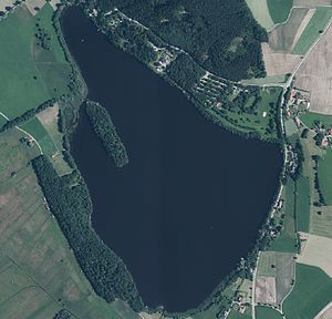
| Orthophoto of the Abtsdorfer See | ||
The Abtsdorfer See , also known as Haarsee , is a swimming lake in the municipality of Saaldorf-Surheim near Laufen , Upper Bavaria .
description
The lake that was created in a mining pit of the glacier after the Salzach Glacier melted at the end of the Würm glacial period is one of the warmest lakes in Bavaria . In 2011 the water temperature fluctuated between 17 ° in May and over 26 ° in July and August. Its dark color does not come from the moor water, but from the humic acidic tributaries from the nearby hair moss. The Haarmoos itself was originally a shallow lake and was called Hui or Haarsee, from which the second completely uncommon name for the Abtsdorfer See probably comes from. The Haarsee was drained from 1772–1774 in order to gain arable land. For this purpose, the lake's only outflow, the Schinderbach, was deepened by two fathoms (approx. 1.75 m in Bavaria) by order of Archbishop Hieronymus Graf Colloredo . Around 1900, consideration was given to lowering the Abtsee again by 80 to 100 cm, but the citizens of Laufen refused.

In the lake lies the elongated, densely forested island of Burgstall . At one point the island is only a few meters from the lake shore. There was a castle there in the Middle Ages , of which nothing can be seen above ground today. The lords of the castle, the lords of Kuchl , were a respected family of knights from Salzburg and in the 14th century also had larger estates in nearby Leobendorf . During the dispute between the Archbishopric of Salzburg and the Duchy of Bavaria, attempts were made to flood the castle, which was built in 1355. For this purpose, some dams were built, which led to the enlargement of the lake and were only reopened in 1558. On Philipp Apian's land panel 19 from 1568, the Abbtsee is drawn with an island on which a church stands and to which a bridge or a footbridge leads from the northwest.
The lake is one of the richest in fish in Bavaria. A local specialty are the so-called bog carp, up to 50 cm long, whose stocks are fished ("harvested") every year on the first weekend in November in the southern part of the lake by lowering the water level and auctioned off at a popular autumn festival with a lot of folk customs.
The lake and the island of Burgstall belong to the municipality of Saaldorf-Surheim in the Berchtesgadener Land district . The northern bank forms the border with the city of Laufen in the Berchtesgadener Land district. The lake is only briefly referred to by residents in the area as Abtsee , after the district of the same name in the city of Laufen on the northern bank.
The lake is located in the Protected Landscape Area of the Abtsdorfer See and the surrounding landscape (LSG-00303.01).
There is a campsite, a clinic and a leisure area by the lake. A hiking trail leads around the lake.
Hydrology
- Catchment area: 21.10 km²
- Tributaries:
- Weidmoosgraben (Gaberlbach) (in the north, across from Burgstall Island)
- Roßgraben (in the west) - main tributary with a length of 4.34 km
- Badhäuslgraben (in the south)
Part of the main tributary, the Roßgraben, as well as the outflow is already called Schinderbach.
Picture gallery
See also
literature
- Heinz Dopsch and Hans Roth (eds.): Laufen and Oberndorf: 1250 years of history, economy and culture on both banks of the Salzach. Laufen / Oberndorf 1998, ISBN 3-00-003359-9 . (Abtsee on p. 21)
- Krauss, H. (2014): The Abtsdorfer See and its water catchment area - academy combines research work with school project seminars. - ANLiegen Natur 36 (1): 125–126, running. PDF 0.2 MB
Individual evidence
- ↑ a b c d e f g h Documentation of the condition and development of the most important lakes in Germany: Part 11 Bavaria (PDF; 1.7 MB)
- ↑ Abtsdorfer See: Results of the 2011 bathing season. (PDF object; 246 kB) Upper Bavaria administrative district / Berchtesgadener Land district office, accessed on November 15, 2011 .
- ↑ Heinz Dopsch and Hans Roth (eds.): Laufen and Oberndorf - 1250 years of history, economy and culture on both banks of the Salzach . Self-published by the city of Laufen and the market town of Oberndorf, Laufen and Oberndorf 1998, ISBN 3-00-003359-9 , p. 385 .
- ^ Walter Brugger, Die Kuchler, in: Das Salzfass NF 2 (1968), p. 44 f


