Burgstall (Abtsdorfer See)
| Burgstall | ||
|---|---|---|
| Abtsdorfer See with Burgstall Island | ||
| Waters | Abtsdorfer See | |
| Geographical location | 47 ° 54 '41 " N , 12 ° 54' 12" E | |
|
|
||
| length | 335 m | |
| width | 90 m | |
| surface | 2.51 ha | |
| Highest elevation | 433 m | |
| Residents | uninhabited | |
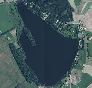
| Orthophoto of the Abtsdorfer See, with the elongated and wooded island of Burgstall in the northwestern part | ||
Burgstall is the name of the only island in the Abtsdorfer See in the municipality of Saaldorf-Surheim in the Berchtesgadener Land district .
geography
The island of Burgstall is located in the northwest of the Abtsdorfer See only twelve meters from the lakeshore, near the Einödhof Seebichl and the Weidmoosgraben tributary on the western bank.
The elongated and densely forested island with spruce measures 335 meters from northwest to southeast and is up to 90 meters wide. The area covers 2.51 hectares . At a height of 433 meters, the island towers over the lake level by six meters.
administration
Like the entire lake, the island belongs to the municipality of Saaldorf-Surheim . It forms the parcel No. 1359 of the Saaldorf district .
history
In the Middle Ages there was a castle on the island , known as Burg Kuchl or castrum Aptsee , of which nothing can be seen today. The founders of the fortification are named in 1355, the Lords of Kuchl , who had received permission from the Salzburg Archbishop Ortolph to build a fortress in the middle of the Abtsee. This castle was conquered during the armed conflict between the Bavarian dukes and the archbishopric of Salzburg , which was on the side of the Habsburgs . This was the reason that the Kuchler left their rule to the victors of the time in return for a payment of 120 pounds Viennese pfennigs .
The castle was destroyed again by troops of the Swabian Federation in 1388 and then remained in ruins. In 1803 considerable remains are said to have existed, which were gradually removed by the residents of the surrounding area for their own purposes.
Piles that can still be seen under water are evidence of a former bridge to the west bank .
On the historical map of the 19th century, the former castle is still indicated in its outline, which has a length of almost 100 meters and a width of around 34 to 38 meters. The foundations can still be clearly seen on the digital terrain model in the BayernAtlas. The course of the former bridge to the west bank at this point 140 meters away at Einödhof Seebichl is also indicated.
literature
- Werner Meyer : Castles in Upper Bavaria - A manual . Verlag Weidlich, Würzburg 1986, ISBN 3-8035-1279-4 , p. 60 .
Individual evidence
- ↑ Measurement with the Bayernviewer .
- ^ Architectural monuments Saaldorf-Surheim
- ^ BayernAtlas. Retrieved November 3, 2019 .
- ↑ Historical land map


