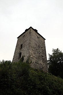
Schellenberger Tower

The Schellenberger Turm ( also called: Passturm or Schellenberger Passturm or Passturm Schellenberg ) served from 1193/94 in what is now Marktschellenberg at the transition to Salzburg as a defensive tower to fortify the border of the increasingly independent Berchtesgadener Land and, after the secularization (1803) until 1823, the stationing of a royal Bavarian border occupation.
Description and location
The Schellenberger Tower has a so-called "Watch Tower" a square floor plan and has four floors in the high Romanesque style and the first floor above a Romanesque arch portal . The construction is completed by a high tent roof .
It is located on the B 305 between the center of Marktschellenberg and the German-Austrian border crossing Hangendenstein am Hangenden Stein , which at this point is 471 m above sea level. NHN allows the lowest and most convenient access to the Berchtesgadener Land or the southern part of the Berchtesgadener Land district in Upper Bavaria .
history
The Schellenberg Tower was built around the same time as the fortifications in Hallthurm in 1193/94 to secure the heartland of the Berchtesgaden monastery, but was only mentioned in a document after a new building in 1252 in 1258. The reason for its establishment were u. a. the attacks of the noble von Guethrat as ministerials of the Salzburg archbishops and their interest in the salt deliveries from Schellenberg. In 1677, when the monastery monastery was elevated to the status of the prince provost of Berchtesgaden and had ruled the Berchtesgadener Land independently for over 100 years , the fortifications were expanded and a gate building used as a toll house was added.
After secularization (1803) and briefly several changes of rule, the Berchtesgadener Land was incorporated into the Kingdom of Bavaria in 1810 . A royal Bavarian border crew was stationed in the tower until 1823. The tower was then abandoned and the border garrison moved to the customs office that was newly built not far from it . The old toll house disrupted the increasing wagon traffic and was demolished in 1841 and three years later the previously difficult to access pass was removed and the road was lowered. In 1937 the German customs moved into a new building (see illustration above with "former customs house"). After the Second World War , the newly established Schellenberg island customs office was opened a little closer to the border in 1953.
At the suggestion of the former district administrator E. Aigner, the pass tower became part of the coat of arms of the municipality of Landschellenberg , which was independent until 1969 and which is now a district or a district of Marktschellenberg .
opening hours
The Schellenberger Tower is open to the public on occasions such as the Open Monument Day and once a month on Sundays from 11 a.m. to 3 p.m.
Starting point for hikes
The starting point for mountain hikes on the Untersberg to the Toni Lenz Hut and the Schellenberger Ice Cave is at the Schellenberger Tower .
Web links
Individual evidence
- ↑ a b c d e f g History of the Schellenberger Tower ( Memento from March 7, 2019 in the Internet Archive ), online at marktschellenberg.de
- ↑ a b c d e Entry on Schellenberg in the private database "Alle Burgen". Retrieved August 10, 2016.
- ↑ Heinrich Bauregger: Berchtesgaden - The most beautiful valley and mountain walks. 51 tours ( memento of August 8, 2016 in the Internet Archive ). Bergverlag Rother , Oberhaching (13th, updated edition) 2013. ISBN 3-7633-4226-5 . P. 49
- ^ Paul Werner, Iris Kürschner: Via ferrata atlas Alps: all via ferratas in the Alps between the Vienna Woods ... , online at books.google.de
- ↑ Official map of the BayernAtlas showing the height of the border crossing, online at geoportal.bayern.de/bayernatlas/
Coordinates: 47 ° 42 ′ 11.6 ″ N , 13 ° 2 ′ 18 ″ E

