
Hanging stone (Hangenden stone pass)

The hanging stone in front of the Kienbergkopf ( Untersberg massif ), which extends to the east but is not connected to it, was a rocky promontory, the location of which near the Berchtesgadener Ache had created a natural bottleneck or a valley pass . It gave its name to the Hangendenstein pass that passed it , which was secured by a fortified border crossing between different ruled areas as early as the 12th century and has served as the Hangendenstein border crossing between Germany and Austria since the end of World War II . Only a small visible remnant of the former rock itself still exists today.
location
From the German side, the federal highway 305 leads to the rest of the Hangenden Stein , which before that last crosses the municipality of Marktschellenberg or the Schellenberger Forest , from the Austrian side the only 3 km long Berchtesgadener Straße (B 106), the one in front from the Salzburg Süd junction the Tauern Autobahn (A 10) from the Hangendenstein district of Grödig and ends at the Hangenden Stein itself. Coming from the Schellenberger Forst in the direction of Grödig, the boulder with the Europe sign in front of it is located on the right hand side right next to the road.
geology
In 1939 broken ledge of the hanging brick was by Lower Cretaceous marly sandstones and calcareous stones marl with chert retention of the Lower Roßfeld formation been established. Structurally , the rock does not belong to the Untersberg massif, but rather - separated from the Untersberg massif by tectonic disturbances running east of the rock in a north-south direction - to the rock formations that make up the Roßfeld in the border of the Berchtesgaden ceiling . The clastic rocks were deposited in a tectonically influenced sedimentation basin during the Lower Cretaceous. The type locality of the Lower Roßfeld Formation is exposed on the Roßfeldhöhenringstrasse and is designated as a geotope there .
Railway tunnel and rock demolition in 1939
Between 1907 and 1938 there was also a train station at the Hangendenstein border crossing for the local railways Berchtesgaden – Hangender Stein and Salzburg – Hangender Stein , which were operated electrically from 1908 onwards , for which a tunnel had been created through the hanging stone . The tunnel was completely demolished in 1939 for a planned double-track expansion. However, during the Second World War, the track expansion was abandoned; instead, the area freed up was used for the construction of today's road route. From the hanging wall stone since only one remained boulder next to the Republic of Austria indicative Europe plate and on the road towards a broader escarpment of the rock.
Picture gallery
Johann Faistenauer (1577 / 78–1643): Das Landt und Fürstliche Stifft Berchtolsgaden (1626)
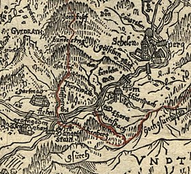
Map excerpt: Red line = border between the prince-provost of Berchtesgaden and the prince-archbishopric of Salzburg , left. u. the "Hanget Stain", center right of the " thurn "
Hermann Reindel (1807–1888): Hanging stone, right. behind the kk toll station (watercolor before 1851)
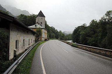
Schellenberger Tower with a former customs house (1937–1953) on the B 305 towards Salzburg. Right Berchtesgaden Ache
_.jpg&filetimestamp=20200727214851&)

.jpg&filetimestamp=20200729162705&)

Individual evidence
- ↑ Digital geological map of Bavaria; Sheet 8244 Berchtesagden-Ost. In: Umweltaltlas Bayern. Bavarian State Office for the Environment, accessed on August 5, 2020 .
- ↑ Type locality of the Roßfeld formation on Roßfeldstrasse. In: Umweltaltlas Bayern. Bavarian State Office for the Environment, August 1, 2019, accessed on August 5, 2020 .
- ↑ Ewald Langenscheidt: Geology of the Berchtesgaden Mountains: an introduction to stratigraphy, facies and tectonics . 2nd Edition. Berchtesgadener Anzeiger, Berchtesgaden 2001, ISBN 3-925647-27-9 , p. 62; 74 ff .
- ^ Stephan Kastner: The railway, Berchtesgaden and the developments at the train station , online at berchtesgadeninfo.de
Coordinates: 47 ° 42 ′ 50.1 ″ N , 13 ° 2 ′ 35.1 ″ E