
Almkanal
The Almkanal is an artificial works channel in the south of the city of Salzburg to the left of the Königsseeache and the Salzach. The Stiftsarm tunnel leading through the Mönchsberg is the oldest medieval water tunnel in Central Europe. It served to supply the city with utility , drinking and extinguishing water as well as the mill operation . Today the Almkanal is primarily important as a recreational area and a cultural monument, but it is also used to generate energy.
From the Königsseeache , once also called “Alm” or “Albe”, the water of the Almkanal is diverted to the left through a weir system next to the Hangendensteinpass - about 100 m after the state border . The 12 km long Almhauptkanal leads in a northerly direction through St. Leonhard , Grödig , Gneis into the Riedenburg . Before and after the Stiftsarm tunnel through the Mönchsberg in the old town it forks in a fan shape into seven arms, all of which - from the left - flow into the Salzach. The difference in altitude from the Königsseeache to the Salzach near Mülln is a good 46 m. As a rule, the Almkanal carries around 5.5 m³ of water per second.
history
The oldest part of the Almkanal network (today's Müllner Arm) was probably built in the 8th century.
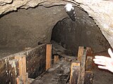
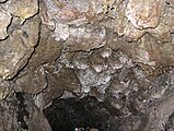
In the years 1137 to 1143, the Salzburg Cathedral Chapter and St. Peter's Abbey dug a tunnel through the Mönchsberg. From then until the end of the archbishopric, the cathedral chapter and the monastery as “Almherren” jointly looked after the Almkanal, until in 1566 the archbishop joined as the third Almherr. The canal is 370 meters long, on average about 0.8 to 1.2 m wide and, depending on the type of vault, 1.50 to 2.20 m high. Initially, it was only supposed to channel the water of the Riedenburgerbach on the edge of the Riedenburger Moor into the city. This amount of water turned out to be too little. An extension to the Rosittenbach therefore seemed necessary.
In 1160 the channel on the edge of the Leopoldskroner Moor, not far from Berchtesgadener Strasse, was completed. The water of the Rosittenbach partly flowed through the Mönchsberg into the city, and partly over the Riedenburgbach to Mülln. The excess water of the extensive Leopoldskron moor also brought additional water, as the moor level was higher than the Almkanal.
In 1286 Kuno von Guetrat ( see also: Gutrat Castle Ruins ) allowed the construction of a five-kilometer-long piercing canal from the Rosittenbach to the Königsseeache at the Hangendensteinpass .
In 1335 Archbishop Friedrich III. the citizens of the city have the right to freely draw water. As a result, the municipal arm with a second tunnel was built through the mountain. This new arm branches off from the Müllner Arm and crosses the inner Riedenburg from south to north. In addition to the citizens' hospital, he mainly supplied mills, grinding shops , milling , forging and sawing.

In 1548 the municipal well house was built on the municipal Almkanal arm, which pumps up the Salzach groundwater with the help of the power of the alpine water. As a result, numerous lines for wells, wash houses, baths, horse ponds and fish chillers were built. The Stiftsarm runs through the city center to the left of the Salzach in four partial arms. It also served as a rubbish channel.
In 1664 the Nonntalarm was built with the Archbishop's Nonntaler Brunnhaus . It served to supply water to the Residenzbrunnen as well as to houses on Nonnberg and in the Kaiviertel .
In the second half of the 19th century, the alpine water drove up to 120 mill wheels, at that time there were over 400 water rights .
The Salzburg Fortress Railway was operated with ballast water from the opening in 1892 to 1959 (after which it was switched to electric motor drive on the rope) and therefore did not operate during the winter. Alm canal water was pumped into an intermediate container in the mountain station in the fortress, up there the water tank of one car was filled for the descent, while the tank of the other one that arrived in the valley was emptied at the same time. The amount of ballast water was based on the rolling resistance plus the weight difference between people traveling uphill and downhill. The nickname Tröpferlbahn comes from the audible water transfer processes.
In the 19th and early 20th centuries, the Almkanal was divided into five Bachmannslehen, which were looked after by the Bachmanns. Since 1937, all users have been united in a water cooperative by the “Almkanalgesetz” (Alm Canal Act). Since then, the operation of the Almhauptkanal has been managed by an “Almmeister”.
present
The tunnel through the Mönchsberg , which was dug between 1137 and 1143, is still in operation today.
.jpg)
Today the Almkanal supplies 14 turbines, including the oldest power station in the province of Salzburg, the Eichetmühle (listed, preserved unchanged in its condition from 1908) and the municipal emergency power generator , as well as ponds, cooling and air conditioning systems (such as those in the festival hall ) with water.
Every year in September the Almabkehr takes place for three weeks , during which all watercourses are fished, drained and repair work is carried out.
Pollard willows on the Almkanal
The polluted willows on the Almkanal in the municipal area of the city of Salzburg are a cultural relic that goes back to the Middle Ages. The now more than 500 pollarded willows along the historic factory canal have been protected as a protected landscape area since 1995 with their rare wood-dwelling insects and since 2015 as a Natura 2000 reserve . The polluted willow stock serves to protect rare wood-dwelling beetle species ("jungle fauna") and to network habitats rich in dead wood in the south of the city.
Recreation, tourism and sports
Recreational routes
The walking and cycling path along the Almkanales forms one of the most important recreational axes in the city of Salzburg, it leads variedly from the city limits in the south through the green spaces of Morzg, the Leopoldskroner Moos and the Riedenburg. Small parts of this overarching recreational path were further supplemented or improved between 2015 and 2018.
The Almkanal in the old town
The waters of the arms of the Almkanal can be seen in several places in the historic old town - apart from the mouths into the Salzach:
- In July 1992 Boris Podrecca designed an artistic fountain on the university square with the Almkanalwasser (Gamperarm), which leaves some irritation, as the meaning of the hole in the ground remains hidden to some. But it is a large horizontal sundial. The pole rod with a spherical knob ( gnomon and nodos [ lat. Network knot ]) is striking . In the pavement there is a noon line and a partially damaged number ring; there are still the brass numbers for the numbers VIII, IX, XI and I.
- If you enter the Petersfriedhof from Kapitelplatz , you will notice the arm of the pen emerging from the mountain. A wooden mill wheel was reinstalled here in 2006, true to the original, which makes the image of the St. Peter's Abbey Mill and the attached Pfisterei (monastery bakery, by far the oldest bakery in the city of Salzburg) visible from the outside.
- In the valley station of the fortress railway , the Almkanal was exposed, artistically designed and provided with explanations.
Bathing operation
For decades the water of the Almkanal - also very cool in summer - has also been used for swimming. Since the turn of the millennium, bathing along the Almkanal has increased significantly on warm summer days. The Almkanal became a meeting place for young people in some places, which also led to disagreements with the local population. A young bull that was up to its neck was crawled out by the Grödig fire brigade in 2016.
Almwelle
With the turning away from the Alm, the construction of the Almwelle (project costs 90,000 euros), also known as Almkanalwelle, for river surfing through the city of Salzburg began at the beginning of September 2010 . This artificially created surf wave based on the model in the Eisbach in Munich is located in Gneiss-Süd between the Eichethofsiedlung and the Birkensiedlung at the site of the former Suchmannschleuse. The (short :) Almwelle - flooded for the first time on September 24, 2010 - is 4.5 m wide and 0.5 m high and is created by a natural gradient, a smooth ramp and two adjustable boards on the bottom. A 15 m long, 8 m wide stilling basin afterwards lets the water speed and the eddies subside again and serves as a safe exit to the left bank. In 2009 the Graz Building Waves team delivered the concept for this surf wave with their 4th project.
Pen arm


Reopened piece of the Gamperarm, one of the mouth arms of the pin arm system of the Almkanal, on Universitätsplatz


Urban arm (Neutorarm)

Urban arm between Reichenhaller Strasse and the mouth of the Mönchsberg tunnel

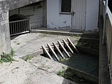
Mouth of the municipal arm (bluish water) into the Salzach


literature
- Heinz Dopsch : The Almkanal - a pioneering achievement in European construction technology. In: Heinz Dopsch (Hrsg.): The oldest monastery in the German-speaking area. Saint Peter in Salzburg. Treasures of European art and culture ( special show of the Cathedral Museum in Salzburg. 7, ZDB -ID 2294851-X ). 3rd State Exhibition from May 15 - October 26, 1982. Office of the Salzburg State Government - Cultural Department, Salzburg 1982, pp. 117–121.
- Heinz Klackl: The Almkanal. Its use then and now. Self-published, Salzburg 2002.
- Romana Ebner, Herbert Weigl: The Salzburg water. History of the water supply of the city of Salzburg (= series of publications of the archive of the city of Salzburg. Volume 39). City Archives and Statistics of the City of Salzburg, Salzburg 2014, ISBN 978-3-900213-22-0 .
Web links
Individual evidence
- ↑ Festungsbahn celebrates its 125th birthday orf.at August 1, 2017, accessed on August 1, 2017.
- ^ Wolfhart Fally: Public time displays in Salzburg. In: Bastei - The magazine of the Salzburg City Association. 68th year, 2019, pp. 4–10.
- ↑ Young bull rescued from channel orf.at, August 11, 2016, accessed August 12, 2016.
- ↑ Dramatic animal rescue in Grödig FMT-Pictures, August 11, 2016, accessed on August 12, 2016.
- ↑ Salzburger Nachrichten, September 7, 2010, Facebook entry from September 19, 2010 https://www.facebook.com/115149295208165/photos/a.115672351822526.11624.115149295208165/115674055155689/?type=1
- ↑ krone.at: Violent argument about surfing in Salzburg's Almkanal ( memento from June 19, 2015 in the Internet Archive )
- ↑ http://www.almkanal.at/surfen_almkanal_welle.html Surfwelle am Almkanal, website of the waterworks cooperative Almhauptkanal, 2011, accessed on April 27, 2015.
- ↑ https://www.facebook.com/pages/Die-Almkanal-Welle/115149295208165 Almkanal Welle - Facebook page, from September 17, 2010, accessed on April 27, 2015
- ↑ https://www.facebook.com/StroemerWaveEngineering/info?tab=milestone About Graz Building Waves> Milestones, 2009, accessed on April 27, 2015
Coordinates: 47 ° 46 ′ 56 ″ N , 13 ° 2 ′ 32 ″ E