
Hangendensteinpass
| Hangendensteinpass ( valley pass ) |
|||
|---|---|---|---|
| Compass direction | North | south | |
| height | 462 m above sea level NHN | ||
| region | Salzburg , Austria | Bavaria , Germany | |
| Waters | Berchtesgadener Ache | ||
| Valley locations | St. Leonhard | Schellenberger Forest | |
| expansion | B 160 | B 305 | |
| Mountains | Hanging stone (in front of the Kienbergkopf , but made up of sediments from the Lower Roßfeld Formation , Berchtesgaden Alps ), rock remains to the left and right of the road | ||
| map | |||
|
|||
| Coordinates | 47 ° 42 '50 " N , 13 ° 2' 34" E | ||

The Hangendensteinpass is a valley pass between the foothills of the Kienbergkopf as part of the Untersbergstock and the Göllmassiv , through which the Berchtesgadener Ache or, on the Austrian side, the Königsseeache flows. The name of the pass is given by the hanging stone as a branch on the side of the Kienbergkopf. Since the 12th century it has been a border crossing between different ruled areas, since the end of the Second World War as a border crossing Hangendenstein between Germany and Austria .
traffic
Road link
From the German side the federal highway 305 leads to the Hangendensteinpass , which last crosses the municipality of Marktschellenberg or the Schellenberger Forst , from the Austrian side the Berchtesgadener Straße (B 106), which leads through the district Hangendenstein of the municipality of Grödig and after a total of 3 km in the junction Salzburg Süd of the Tauern Autobahn (A 10) joins.
Former railway connection
Between 1907 and 1938 there was also a train station at the Hangendenstein border crossing for local railways, first operated by steam, and electrically operated from 1908 on the Berchtesgaden – Hangender Stein and Salzburg – Hangender Stein lines , for which a tunnel had been created through the rocky promontory of the Hangenden Stein . This tunnel, together with the remains of the rock, was demolished in 1939 for a planned double-track expansion, which was abandoned during the Second World War. Instead, the area that was freed up was used for the construction of today's road route.

Railway tunnel through the hanging stone towards Salzburg before electrification of the route (approx. 1907), right. of which the original course of the road and a weir of the Alm Canal
.jpg&filetimestamp=20200729162705&)
History as a border crossing
The Hangendensteinpass has been a border crossing since the Middle Ages - from 1193/94 the Schellenberg Tower , which was expanded over the centuries (built around the same time as the fortifications in Hallthurm ), served as a pass tower to secure the heartland ( Berchtesgadener Land ) of the Berchtesgaden monastery or abbey 1559 the prince provost of Berchtesgaden and its salt deliveries from Schellenberg After the secularization (1803) and briefly several changes of rulership, the Berchtesgadener Land was incorporated into the Kingdom of Bavaria in 1810 and from 1816 to 1823 a royal Bavarian border garrison was stationed in the tower, later in a newly built customs office . After the old toll house was demolished in 1841, the road was lowered three years later. During the time of National Socialism , German customs moved into a new building in 1937. After the Second World War , the newly established Schellenberg island customs office was opened in 1953 .
On June 1, 1816, the “kk Mauthstation Hangendenstein” began its service on the Austrian side. Its former Austrian customs house is still 120 meters northeast of the border crossing at Wehrstraße 2. After the Second World War, a new customs building was built for the Hangendenstein customs office on Berchtesgadener Straße (B 160). The weir road forms a remnant of the original road course before the removal of the railway tunnel, which was driven through the ledge of the hanging stone .
With the Schengen Agreement , border controls at this border crossing were suspended from December 1, 1997.
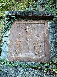
Former border board at the Hangendenstein pass. Crucifixion group, Berchtesgaden monastery coat of arms (left), coat of arms of Provost Gregor Rainer (right). Inscription: "Pax intrantibus et inhabitantibus 1517" (Peace to those who enter and to the residents 1517)

Johann Faistenauer (1577 / 78–1643): Das Landt und Fürstliche Stifft Berchtolsgaden (1626)
Map excerpt: Red line = border between the prince-provost of Berchtesgaden and the prince-archbishopric of Salzburg , left. u. the " Hanget Stain "
Hermann Reindel (1807-1888): hanging stone , right behind the kk toll station (watercolor before 1851)
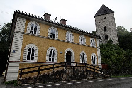
Former Customs house (1937–1953) and Schellenberger Tower , 1.3 km south of the border crossing

Former Austrian customs office or border post on the Hangendenstein pass in the Hangendenstein district of Grödig on the Berchtesgadener Straße (B 106) in the direction of Berchtesgadener Land ; to the left of it is part of the red back of the older kk toll station

_.jpg&filetimestamp=20200727214851&)


Individual evidence
- ^ Stephan Kastner: The railway, Berchtesgaden and the developments at the train station , online at berchtesgadeninfo.de
- ^ Entry on Schellenberg in the private database "Alle Burgen". Retrieved August 10, 2016.
- ↑ a b c History of the Schellenberger Tower ( memento from March 7, 2019 in the Internet Archive ), online at marktschellenberg.de