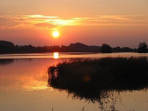
Seehamer See
| Seehamer See | ||
|---|---|---|

|
||
| Sunset at the Seehamer See | ||
| Geographical location | Alpine foothills | |
| Tributaries |
natural: Seebach artificial: Mangfall , Schlierach , Leitzach |
|
| Drain |
of course: Moosbach artificial: to the Leitzachwerke |
|
| Islands | Burgstallinsel, 4 more | |
| Places on the shore | Großseeham , Kleinseeham , Brandlberg | |
| Data | ||
| Coordinates | 47 ° 51 '0 " N , 11 ° 51' 22" E | |
|
|
||
| Altitude above sea level | 653 m above sea level NN | |
| surface | 1.47 km² | |
| length | 2 km | |
| width | 800 m | |
| volume | 5,586,000 m³ | |
| scope | 5.7 km | |
| Maximum depth | 12 m | |
| Middle deep | 3.8 m | |
| Catchment area | 9.3 km² | |
|
particularities |
||
The Seehamer See is located around 40 km southeast of Munich . It belongs to the municipality of Weyarn (district Holzolling), but with its south bank it also borders on the municipality of Irschenberg (district Reichersdorf). It lies above the Leitzach valley between the two main moraine walls of the Inn glacier . In prehistoric times, the several small lakes that were located at this point were called "Easter lakes" (after the fertility goddess Ostara ). The small lakes were formed from dead ice holes and were owned by Weyarn Monastery from 1631 until the secularization of 1803 . In the Staufer period , the largest of the five islands in the lake, the Burgstallinsel, was the Seeham Castle of the Counts of Falkenstein (Großseeham-Falkenstein), the foundations of which were visible until the Leitzachwerke were built. The Seehamer See lies in the landscape protection area Seehamer See with Wattersdorfer Moor .
location
The lake is located directly on the Federal Motorway 8 between Weyarn and Irschenberg and is heavily developed for tourism. You can exit directly from the two motorway car parks “Seehamer See Ost” and “Seehamer See West”. There are two campsites right on the lakeshore, and the lake can be completely hiked on a well-developed hiking trail. The southern shore of the lake is heavily forested. In a wooded area along the south bank there is a spring called Deife ria di (High German devil, stir up ), which also carries fine sand to the surface with the water.
Data
The Seehamer See is on average 3.8 m and a maximum of 12 m deep. With an area of 1.47 km², this results in a volume of 5.586 million m³.
Leitzachwerke
For the operation of the Leitzachwerke , a pumped storage power plant , the lake was dammed in the years 1911 to 1913 and has since formed a single lake. It is now used, fed by supply lines from the Leitzach , Mangfall and Schlierach , as the upper water basin of the power plant to generate energy. Due to the damming it has an average water volume of 6,000,000 m³, whereby around 2,000,000 m³ can be extracted for energy generation.
In 1929 an aqueduct was opened that carries water from the Schlierach and Mangfall into the Seehamer See. The aqueduct is 7.8 kilometers long, including a 2.5 kilometer long tunnel from the Mangfall to the Schlierach and a 3.3 kilometer long tunnel from the Schlierach to the Seehamer See. The maximum transfer volume is limited to 14 cubic meters per second by the capacity of the connecting pipe and channel.
Islands
In the lake there are five small islands with sizes between around 300 and 1600 m² (a total of 4400 m²). The largest is the Burgstallinsel. The islands were all shown as bog and wetlands in the zoning plan of the municipality of Weyarn.
The two largest islands form the parcels 890 and 891 of the Holzolling district . The remaining islands are subsumed under parcel number 899 for the lake (including undeveloped shore areas) and are not recorded separately for surveying purposes.
See also
Web links
Individual evidence
- ↑ Manfred Hiebl. World of castles: Großseeham moated castle (PDF; 300 kB)
- ↑ Berchtesgaden National Park: The Königssee. A limnological project study. 1982. Berchtesgaden National Park Administration, accessed on May 13, 2016 (PDF, 15.6 MB).
- ↑ J. Koppmair: The current state of geodesy . May 7, 1930, p. 89 ( digital copy [PDF]).
- ↑ RMD Consult: Feldolling flood retention basin, explanatory report on the design planning. Wasserwirtschaftsamt Rosenheim, p. 71 , accessed on May 18, 2017 .
- ↑ Weyarn municipality, Miesbach district: 1. Change to the land use plan with incorporation of the landscape plan, 2004-2006 ( memento of the original from October 20, 2007 in the Internet Archive ) Info: The archive link was inserted automatically and has not yet been checked. Please check the original and archive link according to the instructions and then remove this notice. (PDF; 418 kB)


