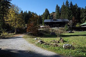
Buchsteinhütte
| Buchsteinhütte leased refuge |
||
|---|---|---|
|
Buchsteinhütte |
||
| location | Municipality Kreuth ; Upper Bavaria ; Valley location: Kreuth community | |
| Mountain range | Bavarian Prealps | |
| Regions | Miesbach | |
| Geographical location: | 47 ° 38 '23.2 " N , 11 ° 40' 46.4" E | |
| Altitude | 1271 m above sea level NHN | |
|
|
||
| owner | Hüttenvereins Buchstein e. V. | |
| Built | 1932-1935 | |
| Construction type | Refuge ; Wood | |
| Development | Forest path | |
| Usual opening times | all year round | |
| accommodation | 25 beds, 15 camps | |
| Web link | Website of the hut association | |
The Buchsteinhütte is a pre-Alpine leased accommodation house with an inn owned by the Hüttenverein Buchstein e. V. in the Mangfall Mountains in the Bavarian Prealps .
location
The hut is located in the area of the mountaineering village Kreuth at an altitude of 1271 m above sea level. NHN or 1260 m, on the way to Tegernseer Hütte and Roßstein and Buchstein and about 80 meters from the western border with the neighboring community of Lenggries . The hut is a base for hiking tours and ski mountaineering in winter. The Hinterer Humpelgraben, a tributary of the Schwarzenbach, flows in the immediate vicinity of the hut .
From a parking lot, about 5 km behind the village of Kreuth, following the B 307 in a southerly direction, you climb up to the Buchsteinhütte for about 2 hours (driving ban). The path leads along the Schwarzenbach, then branches off in a westerly direction and is signposted.
In winter the Buchsteinhütte is also the starting point of a nearly 6 km long toboggan run that leads from the Buchsteinhütte to the Schwarzenbach and then on to the Achenpass road. In the vicinity is next to the Tegernseer Hütte, another refuge that is closed in winter, the Roßsteinalm, the Schwarzentennalm and the Sonnbergalm.
history
The house was built between 1932 and 1935, as was the neighboring hut, which is only open to members of the hut association (at that time the "hut association of the pioneers of the 7th (Bavarian) Pioneer Battalion Munich"). A third lodging house no longer exists. In the early years, the huts were also rented to the Wehrmacht . After the Second World War , the hut was temporarily left to The Falcons .
It was not until the end of 1957 that the Hüttenverein was able to take over the huts again. The supply was ensured from 1961 through the construction of a material ropeway. This was followed by the construction of its own power plant and, in 1988, the construction of its own small sewage treatment plant .
overnight stay
It is possible to spend the night in the mountain hut. There are 25 beds in rooms and 15 in camps. The hut is open all year round and is therefore used in the months when other huts, such as the Tegernseer Hütte, are closed, as a place to stop and stay overnight for ski tours .
Neighboring huts and crossings
- Tegernseer Hütte approx. 1¼ hours
literature
- Alpine club map BY13 Mangfall Mountains West, Tegernsee, Hirschberg 1: 25,000. ISBN 9783937530642
Web links
- Website of the hut association
- Buchsteinhütte planetoutdoor.de
- Buchsteinhütte at outdooractive.com
- Buchsteinhütte at hoehenrausch.de
Individual evidence
- ↑ a b Buchsteinhütte outdooractive.com
- ↑ Although the Buchsteinhütte was going great: Munich association fires long-time hosts merkur.de
- ↑ Buchsteinhütte 1271 m, Mangfall Mountains German Alpine Association alpenverein-muenchen-oberland.de
- ↑ Eugen E. Hüsler: Isarwinkel , Bergverlag Rother , ISBN 978-3-7633-4006-4 , p. 42, limited preview in the Google book search
- ↑ Buchsteinhütte on hoehenrausch.de
- ↑ Buchsteinhütte on Tegernsee
- ↑ Buchsteinhütte mein-tegernsee.de
- ^ Markus Stadler : Base Bavarian Prealps
- ^ Georg and Rosemarie Loth: Tobogganing Upper Bavaria & Tyrol ; ISBN 978-3-7633-3009-6 , Bergverlag Rother , pp. 62–65 limited preview in the Google book search
- ^ A b Hüttenverein Buchstein eV: About us. Retrieved December 9, 2018 .
- ↑ Buchsteinhütte tegernsee.com
- ↑ Buchsteinhütte at bergsteigerdoerfer.org

