
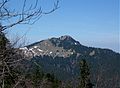
Fockenstein
| Fockenstein | ||
|---|---|---|
 Fockenstein from the south |
||
| height | 1564 m | |
| location | Bavaria , Germany | |
| Mountains | Bavarian Prealps ( Mangfall Mountains ) | |
| Dominance | 2.23 km → Ochsenkamp | |
| Notch height | 337 m ↓ Hirschtalsattel | |
| Coordinates | 47 ° 41 '5 " N , 11 ° 39' 9" E | |
|
||

The Fockenstein is a 1,564 m high mountain in the Bavarian Prealps west of the Tegernsee . Its panorama is comprehensive on all sides, especially large parts of the Mangfall Mountains can be seen.
Location and climbing possibilities
The summit is on the border between the municipalities of Gaißach and Bad Wiessee and can be reached on an easy mountain hike from the valley town of Bad Wiessee via the Aueralm, which is cultivated all year round at an altitude of 1,270 meters, or through the Söllbachtal and the Stinkergraben to the Hirschtalsattel, from Lenggries via the Geierstein or Can also be reached via the Hirschbachtal to the Hirschtalsattel. The Fockenstein is also often climbed in winter, especially as part of a rather simple ski tour. While the way to the Aueralm can usually be mastered without any problems, the steep summit slopes must be carefully assessed with regard to their avalanche danger . The Maximiliansweg from Füssen to Königssee also leads over the Fockenstein. In summer, the ascent from Bad Wiessee takes two hours and the descent 1.5 hours. From Lenggries (from Hohenburg Castle ) over the Hirschtalsattel you have to allow 2.5 hours for the ascent and 2 hours for the descent.
map
- Alpine Club Card Bavarian Alps BY13 Mangfall Mountains West (1: 25000)

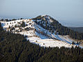
Picture gallery
Fockenstein, Neuhüttenalm , seen from the Hirschberg

Summit cross with Tegernsee in the background
Southern climb


Web links
Individual evidence
- ↑ Bernd Riffler / Rudolf Steiger: Winter mountain tours without skis between Berchtesgaden and Allgäu, Verlag Bruckmann, Munich, 1987, ISBN 3-7654-2139-1 , p. 83f.
- ↑ Tour description on the Fockenstein, accessed on September 3, 2010