
Geierstein
| Geierstein | ||
|---|---|---|
 Geierstein in the background Brauneck and Benediktenwandgruppe |
||
| height | 1491 m | |
| location | Bavaria | |
| Mountains | Bavarian Prealps | |
| Dominance | 2.17 km → Fockenstein | |
| Notch height | 230 m | |
| Coordinates | 47 ° 40 '47 " N , 11 ° 37' 9" E | |
|
||
 Geierstein summit |
||

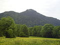
The Geierstein or Geigerstein is a 1,491 m high mountain in the western Mangfall Mountains , part of the Bavarian Prealps , and is located near Lenggries in the Isarwinkel .
nature
The Geierstein is part of a mountain range that runs in a west-east direction and drops steeply to the north and south. Coming from Lenggries, the Geierstein is the first prominent peak. To the east, the ridge is interrupted by the Sommersbachgraben (or shifted to the south towards Schlagkopf); the ridge path requires a descent to 1261 m. Further to the east follows the highest peak of the ridge, the Fockenstein (1564 m); then the ridge holds a height of over 1100 m (popular panorama path) until shortly before Bad Wiessee with the breakthrough of the Tegernsee . From Lenggries to the west, Brauneck and Benediktenwand continue the Fockenstein-Geierstein-Kamm.
The Geierstein is almost completely forested; Only in the immediate vicinity of the peaks does bare limestone emerge from the forest floor.
The summit allows a splendid view of the entire Isarwinkel, the Munich gravel plain (with a foehn view as far as Munich), the Tegernsee mountains, the Wetterstein and Karwendel.
Surname
Which name of the mountain is the "right" one is controversial. The Alpine Club card writes "Geierstein" and under it in small letters and in brackets "Geigerstein".
A legend tells of a hermit playing the violin, whose eye an eagle scratched out - and thus proves that both name forms have existed side by side for a long time.
ways
Due to its ridge location, the Geierstein is only accessible on hiking trails from the west and east. The crossing is part of the Maximiliansweg and thus the European long-distance hiking trail E4 .
The ascent from the west begins at the castle pond, which lies in the middle of the forest just above Lenggries in a hollow between the vineyard and Halsleiten . It can be accessed from the north in 10 minutes from Lenggries train station, from the west via Kalvarienberg , or from the south from the parking lot behind Hohenburg Castle in the Lenggries district of Anger. The path, hardly more than a footprint, runs consistently through steep forest on the south side of the ridge. The marking is currently (as of 2012) patchy and faded. Independent orientation is required in the ascent; the path is easier to see on the descent. Thanks to the forest, the path is easy to walk even on hot days. The Markeck is reached at 1,050 m . Safe footwear and surefootedness are required, especially from the second half , as the ascent on the narrow path becomes increasingly rocky and the path becomes more rooted. Since the ascent is considered quite strenuous and demanding, the Geierstein has remained a calm mountain; it is committed much less often than the neighboring Fockenstein . The ascent time is indicated as two hours on signs in the village.
The access from the west is a little more difficult as it requires a little climbing work and leads over two narrow ridges with steep mountain slopes on the left and right. The summit path begins on a saddle (1320 m), on which an ascent from Lenggries (path 610) and the ridge path towards Fockenstein (1.5 h from Geierstein) meet. This means that various circular routes and crossings are possible; Those arriving by public transport can cross the entire Geierstein-Fockenstein-Kamm and return from Bad Wiessee (bus to the train stations in Tegernsee and Gmund; in summer also a ship to Tegernsee).
proof
- ↑ Alpine Club Map Bavarian Alps. BY13: Mangfall Mountains West. 1: 25000. 1st edition 2009.
- ↑ Sagen aus dem Isarwinkel, Willibald Schmidt, Bad Tölz, 1936, 1979; quoted from http://www.sagen.at/texte/sagen/deutschland/bayern/isarwinkel/geigerstein.html
literature
- Kompass Wanderbuch - Tölzer Land, Isarwinkel (Christian Schneeweiß, 2002) ISBN 3-85491-929-8
- Rother hiking guide - Isarwinkel (Eugen E. Hüsler, 2004) ISBN 3-7633-4006-8
- Topographic map Bad Tölz - Lenggries ISBN 3-86038-485-6
- Alpine Club Map Bavarian Alps. BY13: Mangfall Mountains West. 1: 25000. 1st edition 2009.
- Evamaria Wecker / Luis Stitzinger: Mountain tours by bus & train, Bavarian Alps, Geobuch Verlag, Munich, 2002 ISBN 3-925308-09-1
gallery
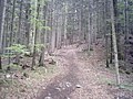
Beginning of the ascent to Geierstein at the castle pond
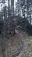
Nameless pre-summit below the Markeck

The Geierstein from Lenggries
North side of the mountain

Northern flank of the summit

South side with striking rock towers Ramlsschnaken (1310 m)


