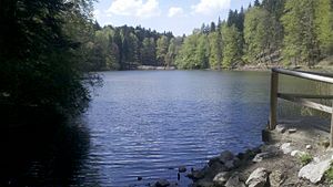
Castle pond (Lenggries)
| Castle pond | ||
|---|---|---|

|
||
| Castle pond from the east | ||
| Geographical location | Bavaria , Germany | |
| Tributaries | (without) | |
| Drain |
to the southeast: → Hohenburger Weiher → Hirschbach → Isar → Danube → Black Sea to the west: → Dorfbach → Isar → ... |
|
| Location close to the shore | Lenggries | |
| Data | ||
| Coordinates | 47 ° 40 ′ 31.5 " N , 11 ° 35 ′ 25.6" E | |
|
|
||
| Altitude above sea level | 720 m above sea level NHN | |
| surface | 2 ha | |
| length | approx. 300 m | |
| width | approx. 100 m | |
|
particularities |
two drains |
|
The castle pond is a body of water near Hohenburg Castle near Lenggries .
It is embedded in a hollow between the mountain ridge from Geierstein in the north, which soon ends to the west, and the vineyard in the south. The pond is wooded all around and has no notable tributaries. The runoff takes place to the southeast to the Hohenburger Weiher as well as to the west to the Dorfbach .
From the 1930s, the western Schlossweiher flow along with two other streams fed the then newly established Lenggries outdoor pool for a while.
Individual evidence
- ↑ The natural pool is “the finest cream” , Lenggrieser Nachrichten 04/2011 ( page no longer available , search in web archives ) Info: The link was automatically marked as defective. Please check the link according to the instructions and then remove this notice. (PDF, 10.5 MB)
Web links
Commons : Schlossweiher - Collection of images
