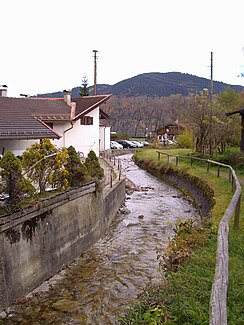
Zeiselbach
| Zeiselbach | ||
|
The Zeiselbach in the center of Bad Wiessee |
||
| Data | ||
| location | Miesbach district | |
| River system | Danube | |
| Drain over | Tegernsee → Mangfall → Inn → Danube → Black Sea | |
| source | below the Aueralm 47 ° 41 ′ 24 ″ N , 11 ° 40 ′ 28 ″ E |
|
| Source height | 1240 m above sea level NN | |
| muzzle | in Bad Wiessee in the Tegernsee Coordinates: 47 ° 42 '43 " N , 11 ° 43' 48" E 47 ° 42 '43 " N , 11 ° 43' 48" E |
|
| Mouth height | 726 m above sea level NN | |
| Height difference | 514 m | |
| Bottom slope | approx. 93 ‰ | |
| length | approx. 5.5 km | |
| Left tributaries | Grundneralmgraben , Markgraben , Hölzlgraben | |
| Right tributaries | Zwergelgraben | |
| Communities | Bad Wiessee | |
The Zeiselbach is an Upper Bavarian mountain stream that flows into the Tegernsee . During its entire course, the stream runs through the municipality of Bad Wiessee . The sources of the Zeiselbach are located below the Aueralm at about 1240 meters above sea level. NN
From the inflow of the Grundneralmgraben, a forest road runs next to the Zeiselbach , which follows the course of the stream over almost its entire length. In the lower part of the creek, the Zeiselbach, like all larger creeks around the Tegernsee, is built from flood protection measures . Shortly before it flows into the Tegernsee, the brook flows directly through the center of Bad Wiessee.
