
Langwassersee
| Langwassersee | ||
|---|---|---|

|
||
| The "Langwassersee", 2020 | ||
| Geographical location | Middle Franconia | |
| Tributaries | Long water | |
| Drain | Langwasser → Fischbach | |
| Islands | 1 approx. 210 m², wooded | |
| Places on the shore | Nuremberg | |
| Data | ||
| Coordinates | 49 ° 25 '1.1 " N , 11 ° 7' 52.3" E | |
|
||
| Altitude above sea level | 323 m above sea level NN | |
| surface | 0.55 ha | |
| length | 200 m | |
| width | 53 m | |

The Langwassersee is an artificially created still water in the Nuremberg district of Langwasser in the Bavarian administrative district of Middle Franconia .
geography
The approximately 0.5 hectare lake is located in the north of the Langwasser district of Nuremberg at an altitude of 323 m . It extends from north-west to south-east within a six-hectare mixed forest, which is surrounded by residential buildings. It draws its water from precipitation and, if required, from the long water that flows past to the north and which can possibly absorb excess water. In the southeast area he has a forested island of about 210 m². Two barrier-free pedestrian bridges lead across the water in a north-south direction. There is no road access.
history
In the area that was originally called " Bey der düren Stange ", there had been a barren coniferous forest that belonged to the Lorenzer Reichswald since the 14th century . During the First World War , paths through the forest were planned there and a " combat firing range " was set up. In the time of National Socialism , the March field was to be built there. During the Nazi party rallies, the armed forces were supposed to perform foam maneuvers. 24 “defense towers” and grandstands for 150,000 spectators were planned. At the beginning of the Second World War only eleven towers and parts of the 14 m high grandstands were completed when construction work came to a standstill. After the end of the war, the area was initially left largely unchanged and used by the US Army as a military training area or camp. Until 1950 a branch track of the rubble railway in Nuremberg ran from Silberbuck to Fischbach through the area.
The towers were blown up in 1966/67 and the area was then left to its own devices. In the 1970s, residential developments were built in the vicinity, the area, which has now been reforested, was visibly littered and also swamped by the floods of the Langwasser. In the late 1980s, the site was redeveloped and the Langwassersee and its small island were laid out as planned. The grandstand fragments or their granite blocks that were already on site were partially used for the bank reinforcements . Since 1987, the sculpture “ Couple ” by the sculptor Klaus Schultze has been located next to the island in the lake . However, the lake has only been recorded in maps since 1994.
today
Today the lake is used intensively as a local recreation area, especially by the residents of the old people's home adjoining to the south and the surrounding residential areas. All parts of the bank are freely accessible via paths all year round, but swimming and fishing is prohibited. In winter the lake is used for ice skating and curling . In addition to some water-loving breeding birds, a beaver has also settled.
Incidents
- On June 5, 2019, a pensioner drowned in the result of a technical defect in his electric wheelchair in Langwassersee.
Picture gallery

Inflow of the long water into the lake
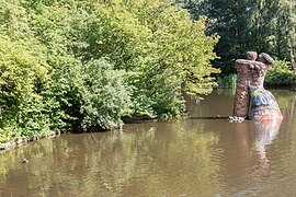
The "couple" from Klaus Schultze

Former bridge in Märzenfeld over the Langwasser


Web links
Individual evidence
- ↑ Location of the Langwassersee on the Bavaria Atlas
- ↑ Bey der düren stange on Bayern Atlas Klassik approx. 1810
- ↑ Combat firing range on the Bavaria Atlas Time Travel 1914
- ↑ a b c d Building equipment for the Langwassersee
- ↑ SculpTour to Klaus Schultze
- ↑ Langwassersee on Bavaria Atlas Time Travel 1994
- ^ Press report Nordbayern.de from June 6, 2019
- ↑ press report web.de