
Administrative community Steinfeld
| coat of arms | Germany map | |
|---|---|---|
 Help on coat of arms |
Coordinates: 50 ° 0 ' N , 11 ° 12' E |
|
| Basic data | ||
| Existing period: | 1978– | |
| State : | Bavaria | |
| Administrative region : | Upper Franconia | |
| County : | Bamberg | |
| Area : | 106.19 km 2 | |
| Residents: | 3151 (Dec. 31, 2019) | |
| Population density : | 30 inhabitants per km 2 | |
| License plate : | BA | |
| Association key : | 09 4 71 5403 | |
| Association structure: | 3 municipalities | |
| Association administration address : |
Steinfeld 86 96 187 Stadelhofen |
|
| Website : | ||
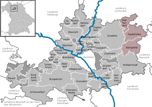
| Location of the Steinfeld administrative community in the Bamberg district | ||
  |
||

The administrative community Steinfeld is located in the district of Bamberg and consists of the following three communities from north to south:
- Königsfeld , 1267 inhabitants, 42.84 km²
- Stadelhofen , 1245 inhabitants, 41.11 km²
- Wattendorf , 639 inhabitants, 22.24 km²
The administrative seat is in Steinfeld in the municipality of Stadelhofen.

In the course of the territorial reform , in addition to Stadelhofen and Steinfeld, eight further districts were merged to form the Steinfeld administrative community, to which the communities of Königsfeld and Wattendorf joined. With around 30 inhabitants per km², the administrative community is comparatively sparsely populated.
Individual evidence
- ↑ "Data 2" sheet, Statistical Report A1200C 202041 Population of the municipalities, districts and administrative districts 1st quarter 2020 (population based on the 2011 census) ( help ).
Administrative communities in the Bamberg district
Baunach | Burgebrach | Ebrach | Lisberg | Steinfeld
Dissolved: Bischberg | Breitengüßbach | Buttenheim | Frensdorf | Memmelsdorf | Stegaurach