
Burgebrach administrative community
| coat of arms | Germany map | |
|---|---|---|
 Help on coat of arms |
Coordinates: 49 ° 50 ' N , 10 ° 45' E |
|
| Basic data | ||
| Existing period: | 1978– | |
| State : | Bavaria | |
| Administrative region : | Upper Franconia | |
| County : | Bamberg | |
| Area : | 112.55 km 2 | |
| Residents: | 8788 (Dec. 31, 2019) | |
| Population density : | 78 inhabitants per km 2 | |
| License plate : | BA | |
| Association key : | 09 4 71 5408 | |
| Association structure: | 2 municipalities | |
| Association administration address : |
Hauptstrasse 3 96138 Burgebrach |
|
| Website : | ||
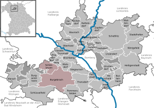
| Location of the Burgebrach administrative community in the Bamberg district | ||
  |
||

The administrative community Burgebrach is located in the district of Bamberg and consists of the following communities:
- Burgebrach , market , 6934 inhabitants, 87.86 km²
- Schönbrunn i.Steigerwald , population 1854, 24.69 km²
The administrative association founded in 1978 is based in Burgebrach.
Individual evidence
- ↑ "Data 2" sheet, Statistical Report A1200C 202041 Population of the municipalities, districts and administrative districts 1st quarter 2020 (population based on the 2011 census) ( help ).
Administrative communities in the Bamberg district
Baunach | Burgebrach | Ebrach | Lisberg | Steinfeld
Dissolved: Bischberg | Breitengüßbach | Buttenheim | Frensdorf | Memmelsdorf | Stegaurach