Stempfermühlquelle
| Stempfermühlquelle | |||
|---|---|---|---|
 The spring basin of the Stempfermühlquelle (in the background the Stempfermühle) |
|||
| location | |||
| Country or region | Forchheim district , Upper Franconia ( Bavaria ) | ||
| Coordinates | 49 ° 46 ′ 15 " N , 11 ° 19 ′ 51" E | ||
|
|||
| geology | |||
| Mountains | Franconian Alb | ||
| Source type | Karst springs | ||
| Exit type | Sources of falls | ||
| Hydrology | |||
| River system | Rhine | ||
| Receiving waters | Wiesent → Regnitz → Main → Rhine → North Sea | ||
| Bulk | 570 l / s | ||
Coordinates: 49 ° 46 ′ 15 ″ N , 11 ° 19 ′ 51 ″ E
The Stempfermühlquelle is a strong karst spring near Gößweinstein in the Forchheim district in Bavaria .
location
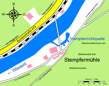
The Stempfermühlquelle is located in the Wiesent valley between Behringersmühle and Muggendorf at the Stempfermühle in Franconian Switzerland . The spring basin is located directly on the left bank of the Wiesent. The federal road 470 and the Wiesenttalbahn run on the opposite side of the river .
Data
The karst spring pours around 500–600 liters of water per second , making it the strongest spring in Franconian Switzerland. There is a digital water meter on the source pot, which shows the daily volume in cubic meters . The water from two enormous cascading springs flows out of the rock and collects in a spring pot. In this there is also a pot source. The water flows over a drain to the stamping mill, which used to be operated with it. Further sources can be seen on the banks of the Wiesent . Even during periods of severe drought, there are no fluctuations in the flow of the spring. It is therefore assumed that their catchment area is very large and even extends into the Veldenstein Forest . Contrast water studies have shown that there is a direct connection between the Stempfermühlquelle and the Fellner sinkhole at a distance of 1.6 kilometers.
history
The Stempfermühle was operated with the spring water until 1924. The spring was redesigned and connected to the Gößweinstein water supply. Despite the excellent quality of the spring water, the water supply could not be maintained due to a non-identifiable water protection area and was dismantled in 1992.
Viktor von Scheffel, who was
resting at the spring, wrote the following verses about it: “The rock gushes strong and cool.
Three sources united close
and carry
their waves at the Stempfermühl ' To Wisunt ...
Where Wiesent once and Elch and Ur
Vreislich trotted to water Thank
God it was only there once -
That water relieved us! "
Geotope
The source is identified by the Bavarian State Office for the Environment as geotope 474Q002. See also the list of geotopes in the Forchheim district .
See also
Web links
Individual evidence
- ↑ a b Information board on site (Die Stempfermühlquelle)
- ↑ Geotope: Stempfermühlquelle near Gössweinstein (accessed on March 22, 2020)


