
Treunitz
|
Treunitz
Municipality Königsfeld
Coordinates: 49 ° 58 ′ 0 ″ N , 11 ° 11 ′ 55 ″ E
|
|
|---|---|
| Height : | 416 m |
| Residents : | 130 |
| Incorporation : | April 1, 1971 |
| Postal code : | 96167 |
| Area code : | 09207 |
 Location of the municipality of Königsfeld in the Bamberg district
|
|
 Town view with St. Sebastian
|
|
Treunitz is a village in Franconian Switzerland with about 150 inhabitants.
It belongs to the municipality of Königsfeld in Upper Franconia in the Bamberg district . Treunitz is located on the Wiesent and at the entrance to the Paradiestal . The Treunitzer Wall is well known among climbers. The name of the place indicates a Slavic background (see the place name Scheßlitz ).
On April 1, 1971, Treunitz was incorporated into Königsfeld.
traffic
Treunitz is on the federal road 22 , which leads from Rottendorf near Würzburg to Cham in the Upper Palatinate , the former Reichsstraße Rottendorf-Weiden.

Village church
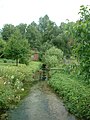
Wiesent in Treunitz

Wiesent in Treunitz

Paradiestal near Treunitz


Individual evidence
- ^ Wilhelm Volkert (ed.): Handbook of Bavarian offices, communities and courts 1799–1980 . CH Beck, Munich 1983, ISBN 3-406-09669-7 , p. 452 .
Web links
Huppendorf | Koenigsfeld | Kotzendorf | Laibarose | Poxdorf | Treunitz | Voitmannsdorf