
Administrative community Gosberg
| coat of arms | Germany map | |
|---|---|---|
 Help on coat of arms |
Coordinates: 49 ° 42 ' N , 11 ° 6' E |
|
| Basic data | ||
| State : | Bavaria | |
| Administrative region : | Upper Franconia | |
| County : | Forchheim | |
| Area : | 29.52 km 2 | |
| Residents: | 5006 (Dec. 31, 2019) | |
| Population density : | 170 inhabitants per km 2 | |
| License plate : | FO, EBS , PEG | |
| Association key : | 09 4 74 5422 | |
| Association structure: | 3 municipalities | |
| Association administration address : |
Reuther Str. 1 91361 Pinzberg |
|
| Website : | ||
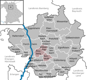
| Location of the Gosberg administrative community in the Forchheim district | ||
  |
||

In the administrative community of Gosberg in the Upper Franconian district of Forchheim , the following communities have come together to handle their administrative business:
- Kunreuth , 1429 inhabitants, 9.79 km²
- Pinzberg , 1970 inhabitants, 13.32 km²
- Wiesenthau , 1607 inhabitants, 6.41 km²
The seat of the administrative community is the municipality of Pinzberg.
Individual evidence
- ↑ "Data 2" sheet, Statistical Report A1200C 202041 Population of the municipalities, districts and administrative districts 1st quarter 2020 (population based on the 2011 census) ( help ).
Administrative communities in the Forchheim district
Dormitz | Ebermannstadt | Effeltrich | Gosberg | Graefenberg | Kirchehrenbach
Dissolved: Egloffstein | Heroldsbach | Langensendelbach | Neunkirchen am Brand