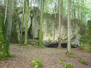
Esper cave
| Esper cave
|
||
|---|---|---|
|
Entrance area Esperhöhle |
||
| Location: | Leutzdorf , Franconian Switzerland , Forchheim district , Bavaria ( Germany ) | |
| Height : | 440 m above sea level NN | |
|
Geographic location: |
49 ° 46 '14.9 " N , 11 ° 17' 47" E | |
|
|
||
| Cadastral number: | D 105 | |
| Geology: | dolomite | |
| Type: | Stalactite cave | |
The Esperhöhle is a natural karst cave ruin near Leutzdorf , a district of the Upper Franconian community Gößweinstein in the Forchheim district in Bavaria .
The cave ruins are located in Franconian Switzerland , part of the Franconian Alb, and were first explored in the 18th century. The cave is designated as a natural monument and registered in the Franconian Alb cave cadastre (HFA) as D 105 and geotope number: 474H004.
Geographical location
The Esperhöhle is located in the Franconian Switzerland-Veldenstein Forest Nature Park, almost 900 meters northwest of the Gößweinstein district of Leutzdorf in the rugged north flank of an altitude of 469.3 m. NN high and wooded mountain. Your input is south above the Wiesent tals to around 440 m above sea level. NN . In front of the cave there is a large sinkhole that was created when the cave roof collapsed.
History and description
The cave was first explored to its end in the 18th century by the pastor Johann Friedrich Esper , after whom it is named.
In the cave, today classified as a ground monument, one could find a multitude of human bones and artifacts from the late Hallstatt and early La Tène periods , which is why a burial site or sacrificial site is assumed there; the finds are in the Natural History Museum in Nuremberg .
The cave ruin consists of grottos , burglaries and ancillary rooms. The most interesting part of the cave is a shaft about 22 meters deep , which can only be accessed using a single rope technique . At the bottom of the so-called Klingloch there are several water basins with continuous stalactites ( stalagmites ) in the cave wall. There are small side chambers in which you can climb and from which you can come out in the Klingloch, two meters higher.
The cave was used by local residents for a long time to store ice . The front parts of the cave are relatively easy to access and lie deep. In the cool cave, a layer of cold air formed due to the storage on the floor, which preserved the ice until August.
literature
- Björn-Uwe Abels : Guide to archaeological monuments in Bavaria: Franconia, Volume 2: Archaeological Guide Upper Franconia . Konrad Theiss Verlag, Stuttgart 1986, ISBN 3-8062-0373-3 , p. 136.
- Brigitte Kaulich, Hermann Schaaf: Small guide to caves around Muggendorf . Natural History Society - Department for Cave and Karst Research, Nuremberg 1980, ISBN 3-922877-00-1 , p. 104 ff.
- Wilhelm von Gümbel: Johann Friedrich Esper . In: Allgemeine Deutsche Biographie (ADB). Volume 6, Duncker & Humblot, Leipzig 1877, p. 376 f.
Individual evidence
- ↑ a b Map services of the Federal Agency for Nature Conservation ( information )
- ↑ Natural monuments in the Forchheim district , accessed on August 25, 2016, at lra-fo.de (PDF; 33.5 MB)
- ↑ Geotop: Esperhöhle , (accessed on March 22, 2020).
Web links
- Esperhöhle , accessed on September 22, 2015, from lfu.bayern.de (PDF; 2.13 MB)
- Esper Cave , on caveseekers.com
- Esper Cave , on showcaves.com


