Engelhardsberg
|
Engelhardsberg
Wiesenttal market
Coordinates: 49 ° 47 ′ 50 " N , 11 ° 17 ′ 38" E
|
|
|---|---|
| Height : | 469 m above sea level NN |
| Incorporation : | January 1, 1972 |
| Postal code : | 91346 |
| Area code : | 09196 |
|
View from the south
|
|
Engelhardsberg is a district of Wiesenttal , a market in the Upper Franconian district of Forchheim in the center of Franconian Switzerland .
On January 1, 1972, Engelhardsberg was incorporated into Wiesenttal.
Geography and transport links
Engelhardsberg is located in the southeastern area of the Wiesenttal market on the district road FO 39 . The state road St 2291 runs far east. The B 470 runs not far to the west .
history
In Engelhardsberg the gentlemen von Streitberg had been wealthy since the Middle Ages. They claimed that the village was protected from the parish fair, which was derived from the nearby Heiliger Bühl chapel.
Attractions
In the list of architectural monuments in Wiesenttal , two architectural monuments are listed for Engelhardsberg :
- a farmhouse (Engelhardsberg 26) from the first half of the 19th century: a ground floor saddle roof building , massive with a half-timbered gable
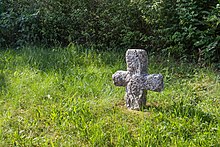
- a stone cross made of dolomite from the 17th / 18th centuries Century (on the county road opposite the village square)
- The Riesenburg hill ruins
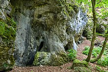
- The natural monument and geotope Dolomite rock group church grottos near Engelhardsberg
Web links
Commons : Engelhardsberg - Collection of images, videos and audio files
Individual evidence
- ^ Wilhelm Volkert (ed.): Handbook of Bavarian offices, communities and courts 1799–1980 . CH Beck, Munich 1983, ISBN 3-406-09669-7 , p. 451 .
- ↑ Dieter Zöberlein: Die von Streitberg, History of a Franconian noble family , self-published, Burggrub 2018, Part 2, pp. 198–199 and Part 3, pp. 76–78.


